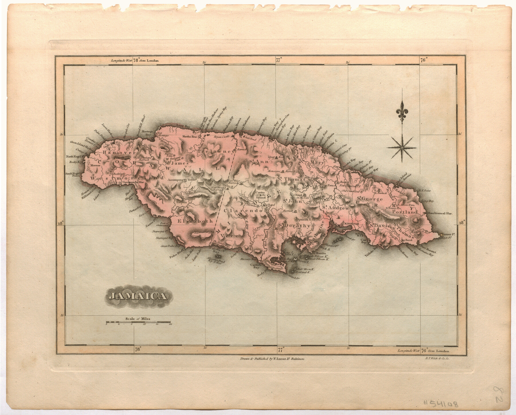
Jamaica
- 
                          Map/Doc95911
- 
                            CollectionNon-GLO Digital Images
- 
                            Object Dates[1823] (Creation Date)
- 
                            People and OrganizationsF. Lucas, Jr. (Publisher)B.T. Welch & Co. (Printer)F. Lucas, Jr. (Draftsman)
- 
                            Height x Width12.4 x 15.5 inches31.5 x 39.4 cm
- 
                            Mediumpaper, etching/engraving/lithograph
- 
                            CommentsImage provided by James Harkins. Map appeared in the "General Atlas" and "A New General Atlas of the West India Islands" by Fielding Lucas, Jr.
Part of: Non-GLO Digital Images
            Velasco, Brazoria County, Texas


                                            Print $40.00                    
                                    
                Velasco, Brazoria County, Texas
1891
Size 67.2 x 50.5 inches
                                Map/Doc 77055
            
            Bird's Eye View of Cuero, De Witt County, Texas


                                            Print $20.00                    
                                    
                Bird's Eye View of Cuero, De Witt County, Texas
1881
Size 18.4 x 25.5 inches
                                Map/Doc 89079
            
            [Movements & Objectives of the 143rd & 144th Infantry on October 13, 1918, Appendix L]
            
                                    ![94124, [Movements & Objectives of the 143rd & 144th Infantry on October 13, 1918, Appendix L], Non-GLO Digital Images](https://historictexasmaps.com/wmedia_w700/maps/94124-1.tif.jpg) 


    ![94124, [Movements & Objectives of the 143rd & 144th Infantry on October 13, 1918, Appendix L], Non-GLO Digital Images](https://historictexasmaps.com/wmedia_w700/maps/94124-1.tif.jpg) 
                                
            
                                            Print $20.00                    
                                    
                [Movements & Objectives of the 143rd & 144th Infantry on October 13, 1918, Appendix L]
1918
Size 16.1 x 16.8 inches
                                Map/Doc 94124
            
            Carta Particular de las Costas Setentrionales del Seno Mexicano que comprehende las de la Florída Ocidental las Márgenes de la Luisiana y toda la rivera que sigue por la Bahía de S. Bernardo y el Rio Bravo del Norte hasta la Laguna Madre


            Carta Particular de las Costas Setentrionales del Seno Mexicano que comprehende las de la Florída Ocidental las Márgenes de la Luisiana y toda la rivera que sigue por la Bahía de S. Bernardo y el Rio Bravo del Norte hasta la Laguna Madre
1807
Size 27.3 x 40.3 inches
                                Map/Doc 94565
            
            Bird's Eye View of the City of Houston, Texas


                                            Print $20.00                    
                                    
                Bird's Eye View of the City of Houston, Texas
1873
Size 24.0 x 30.9 inches
                                Map/Doc 89093
            
            Amérique Septentrionale


                                            Print $20.00                    
                                    
                Amérique Septentrionale
1845
Size 13.8 x 20.3 inches
                                Map/Doc 94571
            
            [Movements & Objectives of the 143rd & 144th Infantry and many other divisions and regiments, 1918]
            
                                    ![94138, [Movements & Objectives of the 143rd & 144th Infantry and many other divisions and regiments, 1918], Non-GLO Digital Images](https://historictexasmaps.com/wmedia_w700/maps/94138-1.tif.jpg) 


    ![94138, [Movements & Objectives of the 143rd & 144th Infantry and many other divisions and regiments, 1918], Non-GLO Digital Images](https://historictexasmaps.com/wmedia_w700/maps/94138-1.tif.jpg) 
                                
            
                                            Print $40.00                    
                                    
                [Movements & Objectives of the 143rd & 144th Infantry and many other divisions and regiments, 1918]
1918
Size 64.2 x 37.5 inches
                                Map/Doc 94138
            
            Houston, Texas (Looking South)


                                            Print $20.00                    
                                    
                Houston, Texas (Looking South)
1891
Size 25.3 x 41.1 inches
                                Map/Doc 89094
            
            Greenville, Tex., County Seat of Hunt County


                                            Print $20.00                    
                                    
                Greenville, Tex., County Seat of Hunt County
1886
Size 17.3 x 24.9 inches
                                Map/Doc 89089
            
            [Movements & Objectives of the 143rd & 144th Infantry on October 9-11, 1918, Appendix E, Nos.2 and 3]
            
                                    ![94131, [Movements & Objectives of the 143rd & 144th Infantry on October 9-11, 1918, Appendix E, Nos.2 and 3], Non-GLO Digital Images](https://historictexasmaps.com/wmedia_w700/maps/94131-1.tif.jpg) 


    ![94131, [Movements & Objectives of the 143rd & 144th Infantry on October 9-11, 1918, Appendix E, Nos.2 and 3], Non-GLO Digital Images](https://historictexasmaps.com/wmedia_w700/maps/94131-1.tif.jpg) 
                                
            
                                            Print $20.00                    
                                    
                [Movements & Objectives of the 143rd & 144th Infantry on October 9-11, 1918, Appendix E, Nos.2 and 3]
1918
Size 41.6 x 19.9 inches
                                Map/Doc 94131
            
            [WWI Topographic Planning Map of the Ardennes department] - Verso
            
                                    ![94130, [WWI Topographic Planning Map of the Ardennes department] - Verso, Non-GLO Digital Images](https://historictexasmaps.com/wmedia_w700/maps/94130-1.tif.jpg) 


    ![94130, [WWI Topographic Planning Map of the Ardennes department] - Verso, Non-GLO Digital Images](https://historictexasmaps.com/wmedia_w700/maps/94130-1.tif.jpg) 
                                
            
                                            Print $20.00                    
                                    
                [WWI Topographic Planning Map of the Ardennes department] - Verso
1918
Size 35.9 x 20.4 inches
                                Map/Doc 94130
            You may also like
            Crosby County


                                            Print $20.00                    
                                             -                         Digital $50.00                                    
                Crosby County
1927
Size 36.1 x 32.4 inches
                                Map/Doc 77255
            
            Glasscock County Rolled Sketch 3


                                            Print $20.00                    
                                             -                         Digital $50.00                                    
                Glasscock County Rolled Sketch 3
1906
Size 19.0 x 13.7 inches
                                Map/Doc 6014
            
            Flight Mission No. CLL-1N, Frame 8, Willacy County


                                            Print $20.00                    
                                             -                         Digital $50.00                                    
                Flight Mission No. CLL-1N, Frame 8, Willacy County
1954
Size 18.3 x 22.1 inches
                                Map/Doc 86995
            
            Crane County Sketch File 11


                                            Print $40.00                    
                                             -                         Digital $50.00                                    
                Crane County Sketch File 11
Size 18.5 x 8.9 inches
                                Map/Doc 19569
            
            Runnels County Sketch File 28


                                            Print $6.00                    
                                    
                Runnels County Sketch File 28
1949
Size 11.3 x 8.8 inches
                                Map/Doc 35493
            
            Edwards County Working Sketch 120


                                            Print $40.00                    
                                             -                         Digital $50.00                                    
                Edwards County Working Sketch 120
1975
Size 25.0 x 48.9 inches
                                Map/Doc 68996
            
            Hidalgo County Working Sketch 4


                                            Print $20.00                    
                                             -                         Digital $50.00                                    
                Hidalgo County Working Sketch 4
1938
Size 43.1 x 39.6 inches
                                Map/Doc 66181
            
            Reagan County Sketch File 27


                                            Print $8.00                    
                                             -                         Digital $50.00                                    
                Reagan County Sketch File 27
1949
Size 11.4 x 8.7 inches
                                Map/Doc 35021
            
            Hood County Rolled Sketch 4


                                            Print $20.00                    
                                             -                         Digital $50.00                                    
                Hood County Rolled Sketch 4
Size 33.4 x 43.1 inches
                                Map/Doc 6220
            
            Chambers County Aerial Photograph Index Sheet 4


                                            Print $20.00                    
                                             -                         Digital $50.00                                    
                Chambers County Aerial Photograph Index Sheet 4
1956
Size 19.7 x 15.6 inches
                                Map/Doc 83685
            
            Brooks County Boundary File 1c


                                            Print $40.00                    
                                             -                         Digital $50.00                                    
                Brooks County Boundary File 1c
Size 63.4 x 6.7 inches
                                Map/Doc 50838
            
            Wharton County Rolled Sketch 13


                                            Print $20.00                    
                                             -                         Digital $50.00                                    
                Wharton County Rolled Sketch 13
1990
Size 22.4 x 28.1 inches
                                Map/Doc 8238
             
                        