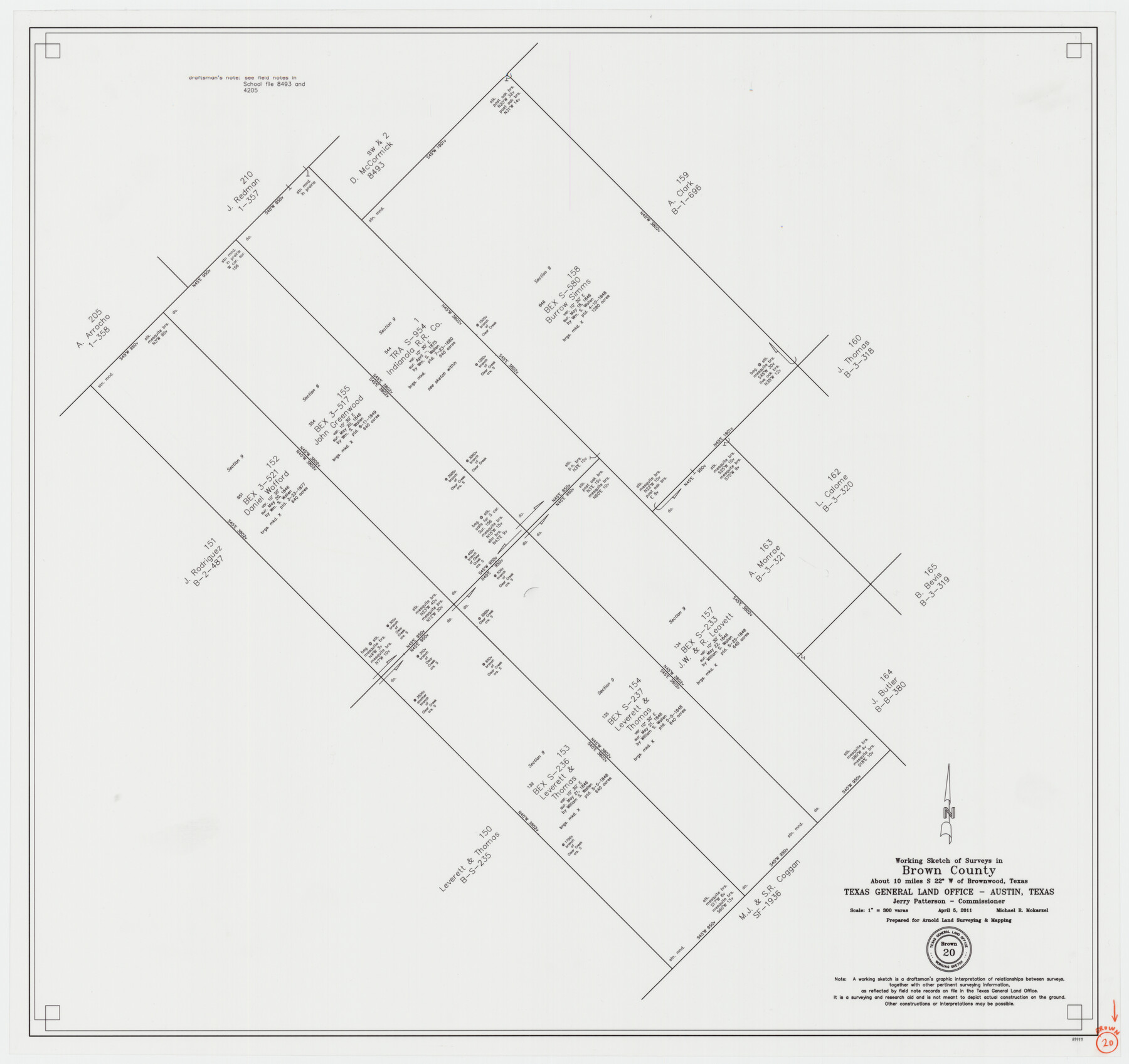
Brown County Working Sketch 20
-
Map/Doc
89999
-
Collection
General Map Collection
-
Object Dates
4/5/2011 (Creation Date)
-
People and Organizations
Michael R. Mokarzel (Draftsman)
-
Counties
Brown
-
Subjects
Surveying Working Sketch
-
Height x Width
32.8 x 34.8 inches
83.3 x 88.4 cm
-
Scale
1" = 300 varas
Part of: General Map Collection
Sutton County Sketch File 45

Print $4.00
- Digital $50.00
Sutton County Sketch File 45
1939
Size 11.2 x 8.6 inches
Map/Doc 37515
Medina County

Print $40.00
- Digital $50.00
Medina County
1915
Size 53.2 x 44.8 inches
Map/Doc 10790
Map of San Augustine County

Print $40.00
- Digital $50.00
Map of San Augustine County
1901
Size 48.8 x 29.3 inches
Map/Doc 16807
Jeff Davis County Working Sketch 16

Print $20.00
- Digital $50.00
Jeff Davis County Working Sketch 16
1954
Size 19.4 x 17.3 inches
Map/Doc 66511
Mills County Sketch File 17

Print $10.00
- Digital $50.00
Mills County Sketch File 17
1912
Size 14.4 x 8.8 inches
Map/Doc 31665
Houston County Sketch File 22

Print $8.00
- Digital $50.00
Houston County Sketch File 22
1852
Size 12.6 x 8.2 inches
Map/Doc 26789
Comal County Sketch File 1

Print $6.00
- Digital $50.00
Comal County Sketch File 1
1846
Size 16.4 x 10.5 inches
Map/Doc 18995
Nacogdoches County Sketch File 11

Print $2.00
- Digital $50.00
Nacogdoches County Sketch File 11
Size 8.0 x 8.8 inches
Map/Doc 32255
Texas Intracoastal Waterway, Aransas Bay to Aransas Pass

Print $20.00
- Digital $50.00
Texas Intracoastal Waterway, Aransas Bay to Aransas Pass
1962
Size 38.7 x 26.8 inches
Map/Doc 73439
San Jacinto County Rolled Sketch 11

Print $20.00
- Digital $50.00
San Jacinto County Rolled Sketch 11
Size 22.7 x 33.6 inches
Map/Doc 7560
Nueces River, Corpus Christi Sheet No. 6

Print $6.00
- Digital $50.00
Nueces River, Corpus Christi Sheet No. 6
1938
Size 31.3 x 31.0 inches
Map/Doc 65095
Trinity River, OwenCrossing Sheet/Elm Fork of Trinity River

Print $20.00
- Digital $50.00
Trinity River, OwenCrossing Sheet/Elm Fork of Trinity River
1914
Size 29.2 x 29.4 inches
Map/Doc 78340
You may also like
Flight Mission No. CUG-3P, Frame 81, Kleberg County

Print $20.00
- Digital $50.00
Flight Mission No. CUG-3P, Frame 81, Kleberg County
1956
Size 18.3 x 22.1 inches
Map/Doc 86256
Montgomery County Sketch File 18

Print $20.00
- Digital $50.00
Montgomery County Sketch File 18
1899
Size 22.1 x 19.6 inches
Map/Doc 42122
Cherokee County Sketch File 27

Print $4.00
- Digital $50.00
Cherokee County Sketch File 27
1852
Size 8.3 x 8.2 inches
Map/Doc 18171
Childress County Sketch File 2

Print $24.00
- Digital $50.00
Childress County Sketch File 2
Size 6.5 x 16.1 inches
Map/Doc 18244
Cochran County

Print $20.00
- Digital $50.00
Cochran County
1913
Size 29.1 x 20.0 inches
Map/Doc 4743
Hutchinson County Working Sketch 7

Print $20.00
- Digital $50.00
Hutchinson County Working Sketch 7
1917
Size 16.5 x 11.9 inches
Map/Doc 66365
Jefferson County Rolled Sketch 61D

Print $20.00
- Digital $50.00
Jefferson County Rolled Sketch 61D
Size 27.2 x 40.5 inches
Map/Doc 6413
Harrison County Working Sketch 29

Print $20.00
- Digital $50.00
Harrison County Working Sketch 29
Size 33.7 x 37.0 inches
Map/Doc 66049
Galveston County NRC Article 33.136 Sketch 93

Digital $50.00
Galveston County NRC Article 33.136 Sketch 93
2020
Map/Doc 97257
Reagan County Sketch File 12

Print $20.00
- Digital $50.00
Reagan County Sketch File 12
1928
Size 23.2 x 18.3 inches
Map/Doc 12218
Burnet County Working Sketch 9

Print $20.00
- Digital $50.00
Burnet County Working Sketch 9
1975
Size 39.7 x 25.2 inches
Map/Doc 67852
