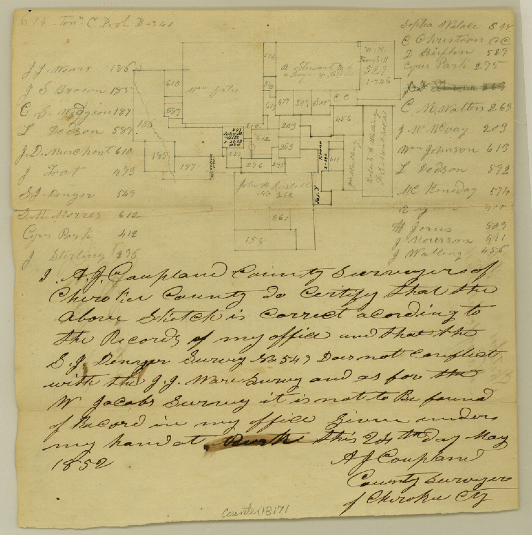
Cherokee County Sketch File 27
[Sketch of area around the John M. Russell survey north of Rusk]
-
Map/Doc
18171
-
Collection
General Map Collection
-
Object Dates
1852/5/24 (Creation Date)
-
People and Organizations
A.J. Coupland (Surveyor/Engineer)
-
Counties
Cherokee
-
Subjects
Surveying Sketch File
-
Height x Width
8.3 x 8.2 inches
21.1 x 20.8 cm
-
Medium
paper, manuscript
Part of: General Map Collection
Liberty County Working Sketch 29

Print $20.00
- Digital $50.00
Liberty County Working Sketch 29
1943
Size 27.3 x 17.0 inches
Map/Doc 70488
Schleicher County Sketch File 4

Print $20.00
- Digital $50.00
Schleicher County Sketch File 4
Size 18.8 x 16.1 inches
Map/Doc 12296
Johnson County Working Sketch 26

Print $20.00
- Digital $50.00
Johnson County Working Sketch 26
2005
Size 22.3 x 41.8 inches
Map/Doc 83574
Flight Mission No. DIX-10P, Frame 147, Aransas County

Print $20.00
- Digital $50.00
Flight Mission No. DIX-10P, Frame 147, Aransas County
1956
Size 18.7 x 22.4 inches
Map/Doc 83949
Midland County Sketch File 19

Print $74.00
- Digital $50.00
Midland County Sketch File 19
1952
Size 11.1 x 8.7 inches
Map/Doc 31587
Travis County Rolled Sketch 58

Print $20.00
- Digital $50.00
Travis County Rolled Sketch 58
Size 37.4 x 25.5 inches
Map/Doc 8049
Glasscock County Working Sketch Graphic Index

Print $20.00
- Digital $50.00
Glasscock County Working Sketch Graphic Index
1933
Size 43.7 x 37.0 inches
Map/Doc 76554
Val Verde County Rolled Sketch 28

Print $20.00
- Digital $50.00
Val Verde County Rolled Sketch 28
Size 28.5 x 36.1 inches
Map/Doc 8110
Flight Mission No. CGI-3N, Frame 66, Cameron County

Print $20.00
- Digital $50.00
Flight Mission No. CGI-3N, Frame 66, Cameron County
1954
Size 18.6 x 22.1 inches
Map/Doc 84560
Newton County Sketch File 23

Print $4.00
- Digital $50.00
Newton County Sketch File 23
1855
Size 10.1 x 8.0 inches
Map/Doc 32403
Maps of Gulf Intracoastal Waterway, Texas - Sabine River to the Rio Grande and connecting waterways including ship channels

Print $20.00
- Digital $50.00
Maps of Gulf Intracoastal Waterway, Texas - Sabine River to the Rio Grande and connecting waterways including ship channels
1966
Size 14.5 x 22.3 inches
Map/Doc 61933
Aransas Pass to Baffin Bay

Print $20.00
- Digital $50.00
Aransas Pass to Baffin Bay
1922
Size 18.6 x 27.8 inches
Map/Doc 73409
You may also like
Rio Grande Rectification Project, El Paso and Juarez Valley

Print $20.00
- Digital $50.00
Rio Grande Rectification Project, El Paso and Juarez Valley
1935
Size 10.7 x 29.6 inches
Map/Doc 60865

Outer Continental Shelf Leasing Maps (Texas Offshore Operations)

Print $20.00
- Digital $50.00
Outer Continental Shelf Leasing Maps (Texas Offshore Operations)
Size 17.6 x 13.8 inches
Map/Doc 75844
Kimble County Sketch File 40

Print $14.00
- Digital $50.00
Kimble County Sketch File 40
1888
Size 10.8 x 8.6 inches
Map/Doc 29003
Crockett County Rolled Sketch 3

Print $20.00
- Digital $50.00
Crockett County Rolled Sketch 3
1886
Size 18.1 x 22.9 inches
Map/Doc 5579
[Block C-41, Section 37, Dawson County, Texas]
![92629, [Block C-41, Section 37, Dawson County, Texas], Twichell Survey Records](https://historictexasmaps.com/wmedia_w700/maps/92629-1.tif.jpg)
Print $20.00
- Digital $50.00
[Block C-41, Section 37, Dawson County, Texas]
1950
Size 14.3 x 12.6 inches
Map/Doc 92629
Grayson County Boundary File 2

Print $14.00
- Digital $50.00
Grayson County Boundary File 2
Size 12.7 x 7.9 inches
Map/Doc 53931
Zavala County Sketch File 15a

Print $6.00
- Digital $50.00
Zavala County Sketch File 15a
1886
Size 14.4 x 9.0 inches
Map/Doc 41321
Map Showing the Relative Positions of the Various Surveys Delineated Thereon

Print $20.00
- Digital $50.00
Map Showing the Relative Positions of the Various Surveys Delineated Thereon
Size 23.0 x 18.6 inches
Map/Doc 91500
Galveston County Rolled Sketch 10

Print $20.00
- Digital $50.00
Galveston County Rolled Sketch 10
1916
Size 21.0 x 38.0 inches
Map/Doc 5952
Flight Mission No. DQN-3K, Frame 6, Calhoun County

Print $20.00
- Digital $50.00
Flight Mission No. DQN-3K, Frame 6, Calhoun County
1953
Size 18.4 x 22.2 inches
Map/Doc 84338
Map of the Straits of Florida and Gulf of Mexico

Print $20.00
- Digital $50.00
Map of the Straits of Florida and Gulf of Mexico
1851
Size 18.3 x 27.5 inches
Map/Doc 72676