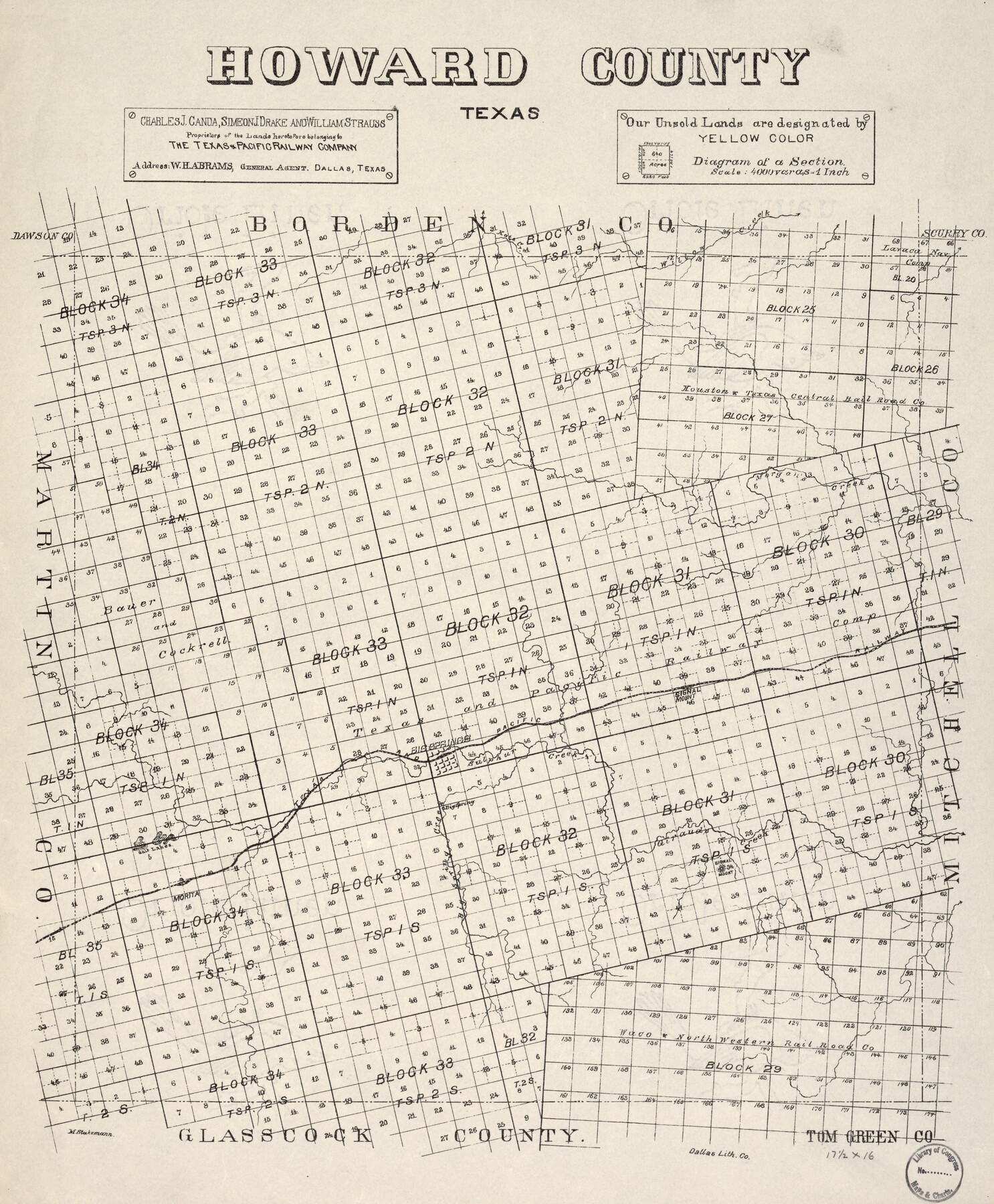
Howard County, Texas
-
Map/Doc
93589
-
Collection
Library of Congress
-
Object Dates
1890 (Creation Date)
-
People and Organizations
Texas & Pacific Railway Co. (Publisher)
M. Stakeman (Author)
-
Subjects
County
-
Height x Width
16.5 x 16.5 inches
41.9 x 41.9 cm
-
Comments
For more information see here. Prints available from the GLO courtesy of Library of Congress, Geography and Map Division.
Part of: Library of Congress
Gray's railroad map of Texas.

Print $20.00
Gray's railroad map of Texas.
1878
Size 26.4 x 16.1 inches
Map/Doc 93597


Panorama of the seat of war - Birds eye view of Texas and part of Mexico

Print $20.00
Panorama of the seat of war - Birds eye view of Texas and part of Mexico
1861
Size 21.6 x 28.9 inches
Map/Doc 93360
Map of Stephens County, Texas

Print $20.00
Map of Stephens County, Texas
1870
Size 24.0 x 19.3 inches
Map/Doc 93588
Fort Worth, Tex. "The Queen of the Prairies", County Seat of Tarrant County

Print $20.00
Fort Worth, Tex. "The Queen of the Prairies", County Seat of Tarrant County
1886
Size 28.8 x 38.6 inches
Map/Doc 93470
Map of the route of B'vt. Maj. A. Moore's scout, April 11th to June 12th 1869

Print $20.00
Map of the route of B'vt. Maj. A. Moore's scout, April 11th to June 12th 1869
1872
Size 23.6 x 40.9 inches
Map/Doc 93566
Greenville, Tex., County Seat of Hunt County, 1886

Print $20.00
Greenville, Tex., County Seat of Hunt County, 1886
1886
Size 20.4 x 28.3 inches
Map/Doc 93476
Map of Caldwell County, Texas

Print $20.00
Map of Caldwell County, Texas
1879
Size 17.4 x 21.5 inches
Map/Doc 88914


Denison, Texas, Grayson County 1886

Print $20.00
Denison, Texas, Grayson County 1886
1886
Size 21.1 x 30.5 inches
Map/Doc 93466
You may also like
Parker County Rolled Sketch 6

Print $20.00
- Digital $50.00
Parker County Rolled Sketch 6
Size 28.3 x 34.1 inches
Map/Doc 7207

A true copy of Peck's field book pages 56 to 63 except classification of lands

Print $40.00
- Digital $50.00
A true copy of Peck's field book pages 56 to 63 except classification of lands
Size 6.3 x 69.2 inches
Map/Doc 89716
Brazoria County Sketch File 53

Print $14.00
- Digital $50.00
Brazoria County Sketch File 53
1919
Size 14.2 x 8.6 inches
Map/Doc 15316
Orange County Sketch File B

Print $20.00
- Digital $50.00
Orange County Sketch File B
1890
Size 17.6 x 26.0 inches
Map/Doc 12130
Trinity River, Post Oak Creek Sheet

Print $4.00
- Digital $50.00
Trinity River, Post Oak Creek Sheet
1930
Size 20.6 x 23.0 inches
Map/Doc 65227
Map of Nueces County

Print $20.00
- Digital $50.00
Map of Nueces County
1875
Size 24.6 x 37.4 inches
Map/Doc 3919
Galveston County

Print $40.00
- Digital $50.00
Galveston County
1939
Size 42.9 x 54.9 inches
Map/Doc 77287
Pecos County Working Sketch Graphic index - northwest part - sheet A

Print $20.00
- Digital $50.00
Pecos County Working Sketch Graphic index - northwest part - sheet A
1975
Size 42.2 x 42.6 inches
Map/Doc 76663
Cochran County Rolled Sketch 5

Print $20.00
- Digital $50.00
Cochran County Rolled Sketch 5
1949
Size 21.5 x 22.0 inches
Map/Doc 5502
Menard County Rolled Sketch 2

Print $20.00
- Digital $50.00
Menard County Rolled Sketch 2
1883
Size 25.0 x 19.9 inches
Map/Doc 6752
Map of Red River Division of the International & Great Northern Railroad

Print $40.00
- Digital $50.00
Map of Red River Division of the International & Great Northern Railroad
Size 24.1 x 107.0 inches
Map/Doc 64476