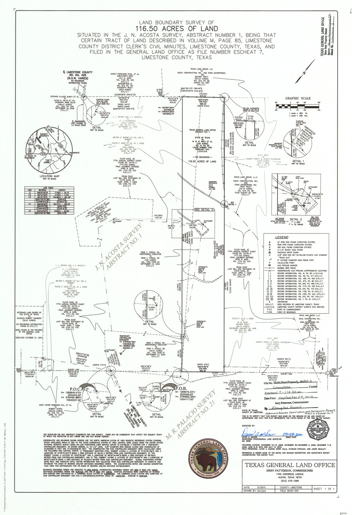
Limestone County State Real Property Sketch 1
Land boundary survey of 116.50 acres of land situated in the J. N. Acosta Survey, Abstract number 1
-
Map/Doc
89570
-
Collection
General Map Collection
-
Object Dates
9/23/2010 (Creation Date)
9/24/2010 (File Date)
-
People and Organizations
David A. McDow (Surveyor/Engineer)
David A. McDow (Draftsman)
-
Counties
Limestone
-
Subjects
State Real Property
-
Height x Width
35.9 x 24.6 inches
91.2 x 62.5 cm
-
Medium
mylar, print
-
Scale
1" = 300 ft. = 108 varas
-
Comments
See GLO Escheat File 7
Part of: General Map Collection
Real County Working Sketch 71

Print $20.00
- Digital $50.00
Real County Working Sketch 71
1976
Size 31.8 x 29.1 inches
Map/Doc 71963
Val Verde County Sketch File 44A

Print $10.00
- Digital $50.00
Val Verde County Sketch File 44A
1940
Size 14.5 x 8.8 inches
Map/Doc 39311
Foard County Boundary File 4a

Print $40.00
- Digital $50.00
Foard County Boundary File 4a
Size 16.9 x 45.4 inches
Map/Doc 53522
Loving County Working Sketch 23

Print $20.00
- Digital $50.00
Loving County Working Sketch 23
1952
Size 15.1 x 31.5 inches
Map/Doc 70657
Preliminary Chart of Galveston Bay, Texas

Print $20.00
- Digital $50.00
Preliminary Chart of Galveston Bay, Texas
1855
Size 22.5 x 18.4 inches
Map/Doc 69867
Stonewall County Rolled Sketch 11

Print $20.00
- Digital $50.00
Stonewall County Rolled Sketch 11
Size 33.2 x 28.1 inches
Map/Doc 7867
Wilbarger County Working Sketch 20

Print $20.00
- Digital $50.00
Wilbarger County Working Sketch 20
1976
Size 27.4 x 43.4 inches
Map/Doc 72558
Oldham County Sketch File 8

Print $4.00
- Digital $50.00
Oldham County Sketch File 8
Size 7.9 x 11.9 inches
Map/Doc 33239
Hardin County Sketch File 20

Print $6.00
- Digital $50.00
Hardin County Sketch File 20
Size 9.4 x 7.9 inches
Map/Doc 25137
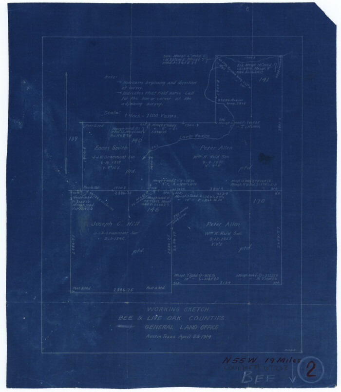
Bee County Working Sketch 2
Print $3.00
- Digital $50.00
Bee County Working Sketch 2
1914
Size 11.0 x 9.6 inches
Map/Doc 67252
Flight Mission No. DAG-19K, Frame 60, Matagorda County

Print $20.00
- Digital $50.00
Flight Mission No. DAG-19K, Frame 60, Matagorda County
1952
Size 18.6 x 22.2 inches
Map/Doc 86387
Trinity County Sketch File 33

Print $6.00
- Digital $50.00
Trinity County Sketch File 33
1922
Size 11.2 x 8.9 inches
Map/Doc 38572
You may also like

Rockwall County Sketch File 5

Print $6.00
Rockwall County Sketch File 5
1861
Size 13.0 x 8.3 inches
Map/Doc 35422
Terrell County Sketch File 34

Print $12.00
- Digital $50.00
Terrell County Sketch File 34
1960
Size 9.7 x 8.5 inches
Map/Doc 37984
Reeves County Rolled Sketch 18

Print $20.00
- Digital $50.00
Reeves County Rolled Sketch 18
1963
Size 23.4 x 27.4 inches
Map/Doc 7487
The Republic County of Jackson. Spring 1842

Print $20.00
The Republic County of Jackson. Spring 1842
2020
Size 15.6 x 21.8 inches
Map/Doc 96190
Garza County Sketch File 3

Print $20.00
- Digital $50.00
Garza County Sketch File 3
1879
Size 18.6 x 17.6 inches
Map/Doc 11544
Jones Subdivision of Sections 28 and 32, Block "A' and Section 2, Block "D3"

Print $2.00
- Digital $50.00
Jones Subdivision of Sections 28 and 32, Block "A' and Section 2, Block "D3"
1928
Size 8.7 x 8.7 inches
Map/Doc 92708
Hardin County Rolled Sketch 24

Print $20.00
- Digital $50.00
Hardin County Rolled Sketch 24
1998
Size 27.2 x 38.6 inches
Map/Doc 6092
Upton County Sketch File 43

Print $22.00
- Digital $50.00
Upton County Sketch File 43
1988
Size 11.4 x 8.8 inches
Map/Doc 38920
Blanco County Rolled Sketch 17

Print $20.00
- Digital $50.00
Blanco County Rolled Sketch 17
Size 18.0 x 23.9 inches
Map/Doc 5153
Nueces County Rolled Sketch 45

Print $20.00
- Digital $50.00
Nueces County Rolled Sketch 45
1941
Size 44.3 x 43.7 inches
Map/Doc 9603
[H. & T. C. RR. Company, Block 47 and Vicinity]
![91413, [H. & T. C. RR. Company, Block 47 and Vicinity], Twichell Survey Records](https://historictexasmaps.com/wmedia_w700/maps/91413-1.tif.jpg)
Print $20.00
- Digital $50.00
[H. & T. C. RR. Company, Block 47 and Vicinity]
Size 18.8 x 13.6 inches
Map/Doc 91413