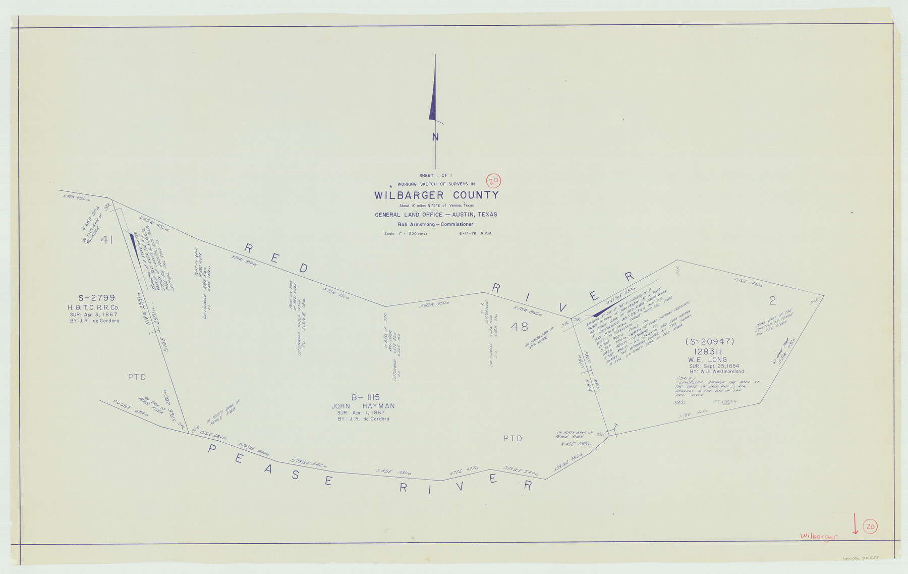
Wilbarger County Working Sketch 20
-
Map/Doc
72558
-
Collection
General Map Collection
-
Object Dates
6/17/1976 (Creation Date)
-
People and Organizations
Rosendo V. Molina (Draftsman)
-
Counties
Wilbarger
-
Subjects
Surveying Working Sketch
-
Height x Width
27.4 x 43.4 inches
69.6 x 110.2 cm
-
Scale
1" = 200 varas
Part of: General Map Collection
Hardin County Sketch File 3

Print $4.00
- Digital $50.00
Hardin County Sketch File 3
Size 7.7 x 4.6 inches
Map/Doc 25086

Trinity County Sketch File 22

Print $23.00
- Digital $50.00
Trinity County Sketch File 22
1877
Size 9.4 x 12.3 inches
Map/Doc 38550
Upton County Sketch File 21

Print $20.00
- Digital $50.00
Upton County Sketch File 21
1927
Size 15.0 x 23.7 inches
Map/Doc 12518
Lynn County Rolled Sketch S

Print $20.00
- Digital $50.00
Lynn County Rolled Sketch S
Size 21.1 x 38.7 inches
Map/Doc 6654
[Maps of surveys in Reeves & Culberson Cos]
![61143, [Maps of surveys in Reeves & Culberson Cos], General Map Collection](https://historictexasmaps.com/wmedia_w700/maps/61143.tif.jpg)
Print $20.00
- Digital $50.00
[Maps of surveys in Reeves & Culberson Cos]
1937
Size 30.7 x 24.9 inches
Map/Doc 61143
Right of Way Location Map, San Antonio & Aransas Pass, Station 656…

Print $4.00
- Digital $50.00
Right of Way Location Map, San Antonio & Aransas Pass, Station 656…
1919
Size 11.8 x 18.6 inches
Map/Doc 62567
Val Verde County Sketch File 14

Print $20.00
- Digital $50.00
Val Verde County Sketch File 14
1879
Size 19.8 x 14.7 inches
Map/Doc 12565
Right of Way and Track Map, Houston & Texas Central R.R. operated by the T. and N. O. R.R., Fort Worth Branch

Print $40.00
- Digital $50.00
Right of Way and Track Map, Houston & Texas Central R.R. operated by the T. and N. O. R.R., Fort Worth Branch
1918
Size 30.9 x 56.9 inches
Map/Doc 64783
Hale County Sketch File 3

Print $4.00
- Digital $50.00
Hale County Sketch File 3
1888
Size 8.6 x 12.7 inches
Map/Doc 24723
Rusk County Sketch File 18

Print $4.00
Rusk County Sketch File 18
Size 8.3 x 8.9 inches
Map/Doc 35524
Plan of the City of Galveston, Texas

Print $20.00
- Digital $50.00
Plan of the City of Galveston, Texas
1845
Size 19.3 x 41.8 inches
Map/Doc 4665
You may also like
San Benito, Texas in the Lower Rio Grande Valley [Frisco Lines]
![95795, San Benito, Texas in the Lower Rio Grande Valley [Frisco Lines], Cobb Digital Map Collection](https://historictexasmaps.com/wmedia_w700/maps/95795.tif.jpg)
Print $20.00
- Digital $50.00
San Benito, Texas in the Lower Rio Grande Valley [Frisco Lines]
1910
Size 19.5 x 19.4 inches
Map/Doc 95795
Tom Green County Rolled Sketch 6

Print $20.00
- Digital $50.00
Tom Green County Rolled Sketch 6
Size 21.6 x 17.1 inches
Map/Doc 7995
Flight Mission No. BRA-16M, Frame 150, Jefferson County

Print $20.00
- Digital $50.00
Flight Mission No. BRA-16M, Frame 150, Jefferson County
1953
Size 18.5 x 22.3 inches
Map/Doc 85756
Chambers County Sketch File 24

Print $20.00
- Digital $50.00
Chambers County Sketch File 24
1909
Size 34.1 x 14.5 inches
Map/Doc 11065
Plat of Resurvey of Section 36, T. 4S., R. 14W., Indian Meridian, Oklahoma

Print $4.00
- Digital $50.00
Plat of Resurvey of Section 36, T. 4S., R. 14W., Indian Meridian, Oklahoma
1917
Size 18.1 x 22.6 inches
Map/Doc 75152
Bell County Sketch File 16

Print $4.00
- Digital $50.00
Bell County Sketch File 16
1862
Size 12.0 x 8.3 inches
Map/Doc 14396
Map of Ochiltree County, Texas

Print $20.00
- Digital $50.00
Map of Ochiltree County, Texas
Size 17.9 x 14.6 inches
Map/Doc 4610
Young County Working Sketch 25

Print $20.00
- Digital $50.00
Young County Working Sketch 25
1982
Size 12.6 x 14.4 inches
Map/Doc 62048
Bien & Sterner’s New Rail Road Map of the United States

Price $20.00
Bien & Sterner’s New Rail Road Map of the United States
2022
Size 3.6 x 4.9 inches
Map/Doc 97020
Upshur County Sketch File 20

Print $4.00
- Digital $50.00
Upshur County Sketch File 20
1873
Size 5.7 x 8.3 inches
Map/Doc 38792

Flight Mission No. CRE-3R, Frame 42, Jackson County

Print $20.00
- Digital $50.00
Flight Mission No. CRE-3R, Frame 42, Jackson County
1956
Size 18.6 x 22.4 inches
Map/Doc 85389