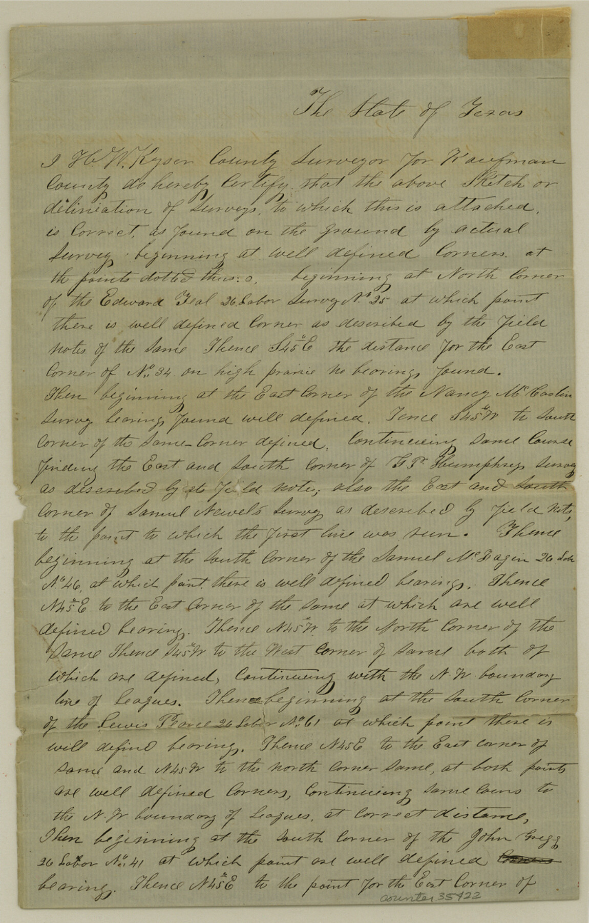
Rockwall County Sketch File 5
[Surveyor's explanation regarding area south and east of Rockwall]
-
Map/Doc
35422
-
Collection
General Map Collection
-
Object Dates
9/3/1961 (Creation Date)
-
People and Organizations
H.W. Kyser (Surveyor/Engineer)
-
Counties
Rockwall
-
Subjects
Surveying Sketch File
-
Height x Width
13.0 x 8.3 inches
33.0 x 21.1 cm
-
Medium
paper, manuscript
Part of: General Map Collection
Dickens County Sketch File GW3

Print $40.00
- Digital $50.00
Dickens County Sketch File GW3
Size 13.9 x 26.6 inches
Map/Doc 11335
Flight Mission No. BQY-4M, Frame 31, Harris County

Print $20.00
- Digital $50.00
Flight Mission No. BQY-4M, Frame 31, Harris County
1953
Size 18.5 x 22.3 inches
Map/Doc 85246
Sutton County Working Sketch 41

Print $20.00
- Digital $50.00
Sutton County Working Sketch 41
1950
Size 22.4 x 33.8 inches
Map/Doc 62384
Map of Bexar County

Print $20.00
- Digital $50.00
Map of Bexar County
1896
Size 45.2 x 40.2 inches
Map/Doc 4885
Collin County Working Sketch 3

Print $20.00
- Digital $50.00
Collin County Working Sketch 3
1935
Size 25.8 x 41.7 inches
Map/Doc 68097
Smith County Sketch File 1

Print $4.00
- Digital $50.00
Smith County Sketch File 1
Size 9.0 x 10.5 inches
Map/Doc 36746
Navasota River, Grayson Crossing Sheet

Print $20.00
- Digital $50.00
Navasota River, Grayson Crossing Sheet
1937
Size 42.8 x 21.1 inches
Map/Doc 65071

Pecos County Rolled Sketch 22

Print $40.00
- Digital $50.00
Pecos County Rolled Sketch 22
1886
Size 73.4 x 45.2 inches
Map/Doc 93461
Crockett County Rolled Sketch P

Print $20.00
- Digital $50.00
Crockett County Rolled Sketch P
1927
Size 24.3 x 47.3 inches
Map/Doc 8696
Map of Prison Properties in Vicinity of Huntsville, Walker County, Texas

Print $20.00
- Digital $50.00
Map of Prison Properties in Vicinity of Huntsville, Walker County, Texas
1933
Size 36.6 x 43.0 inches
Map/Doc 62992
Flight Mission No. CLL-1N, Frame 190, Willacy County

Print $20.00
- Digital $50.00
Flight Mission No. CLL-1N, Frame 190, Willacy County
1954
Size 18.5 x 22.2 inches
Map/Doc 87060
You may also like

Township 1 South Range 12 West, South Western District, Louisiana

Print $20.00
- Digital $50.00
Township 1 South Range 12 West, South Western District, Louisiana
1884
Size 19.5 x 24.7 inches
Map/Doc 65880
Flight Mission No. DAG-21K, Frame 99, Matagorda County

Print $20.00
- Digital $50.00
Flight Mission No. DAG-21K, Frame 99, Matagorda County
1952
Size 17.5 x 16.3 inches
Map/Doc 86428
1882 Map of the Texas & Pacific R-Y Reserve

Print $20.00
- Digital $50.00
1882 Map of the Texas & Pacific R-Y Reserve
1887
Size 44.5 x 31.7 inches
Map/Doc 83559
Webb County Sketch File 13

Print $4.00
- Digital $50.00
Webb County Sketch File 13
1877
Size 12.9 x 8.1 inches
Map/Doc 39801
[H. & T. C. RR. Company, Block 47]
![91162, [H. & T. C. RR. Company, Block 47], Twichell Survey Records](https://historictexasmaps.com/wmedia_w700/maps/91162-1.tif.jpg)
Print $20.00
- Digital $50.00
[H. & T. C. RR. Company, Block 47]
1921
Size 13.1 x 20.6 inches
Map/Doc 91162
The Republic County of Austin. Defined, May 24, 1838

Print $20.00
The Republic County of Austin. Defined, May 24, 1838
2020
Size 14.7 x 21.6 inches
Map/Doc 96082
Chambers County NRC Article 33.136 Sketch 4

Print $48.00
- Digital $50.00
Chambers County NRC Article 33.136 Sketch 4
2003
Size 18.2 x 24.3 inches
Map/Doc 78569
Controlled Mosaic by Jack Amman Photogrammetric Engineers, Inc - Sheet 37

Print $20.00
- Digital $50.00
Controlled Mosaic by Jack Amman Photogrammetric Engineers, Inc - Sheet 37
1954
Size 20.0 x 24.0 inches
Map/Doc 83491
Mason County Sketch File 21A

Print $20.00
- Digital $50.00
Mason County Sketch File 21A
1932
Size 19.2 x 26.6 inches
Map/Doc 12037
Bexar County Working Sketch 15

Print $20.00
- Digital $50.00
Bexar County Working Sketch 15
1972
Size 38.3 x 43.3 inches
Map/Doc 67331
Atascosa County Working Sketch 1a

Print $20.00
- Digital $50.00
Atascosa County Working Sketch 1a
1908
Size 35.8 x 40.2 inches
Map/Doc 67194