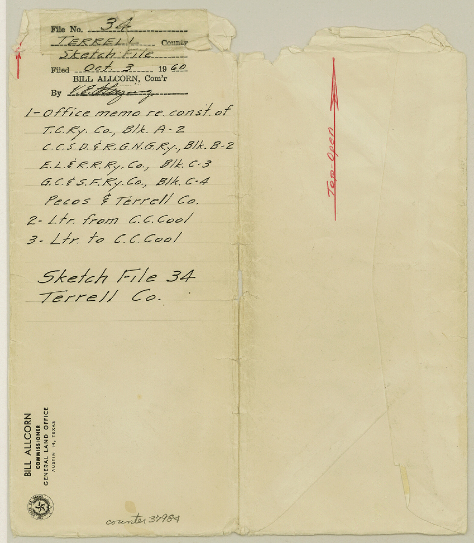
Terrell County Sketch File 34
[Office memo and correspondence regarding construction of T. C. Ry. Co. Block A-2, C. C. S. D. & R. G. N. G. Ry. Co. Block B-2, E. L. & R. R. Ry. Co. Block C-3, and G. C. & S. F. Ry. Co. Block C-4]
-
Map/Doc
37984
-
Collection
General Map Collection
-
Object Dates
9/1960 (Creation Date)
10/3/1960 (File Date)
9/12/1960 (Correspondence Date)
9/30/1960 (Correspondence Date)
-
People and Organizations
Clifford C. Cool (Surveyor/Engineer)
-
Counties
Terrell Pecos
-
Subjects
Surveying Sketch File
-
Height x Width
9.7 x 8.5 inches
24.6 x 21.6 cm
-
Medium
paper, print
-
Comments
See Terrell County Rolled Sketch JAS (9988) for sketch and Pecos County Sketch File 102 (34014) for another copy of the memo.
Related maps
Pecos County Sketch File 102

Print $4.00
- Digital $50.00
Pecos County Sketch File 102
Size 9.9 x 4.4 inches
Map/Doc 34014
Terrell County Rolled Sketch JAS

Print $40.00
- Digital $50.00
Terrell County Rolled Sketch JAS
1936
Size 48.5 x 40.0 inches
Map/Doc 9988
Part of: General Map Collection
Guadalupe County Sketch File 1a

Print $4.00
- Digital $50.00
Guadalupe County Sketch File 1a
1859
Size 12.6 x 7.9 inches
Map/Doc 24646
Map of a part of Fisher and Miller's Colony - Harvey's District

Print $20.00
- Digital $50.00
Map of a part of Fisher and Miller's Colony - Harvey's District
1856
Size 18.6 x 24.5 inches
Map/Doc 4658
Throckmorton County Working Sketch 6

Print $20.00
- Digital $50.00
Throckmorton County Working Sketch 6
1952
Size 24.7 x 21.7 inches
Map/Doc 62115
Terry County Sketch File 8

Print $20.00
- Digital $50.00
Terry County Sketch File 8
1932
Size 23.2 x 42.5 inches
Map/Doc 10393
Wilbarger County Sketch File 7a

Print $4.00
- Digital $50.00
Wilbarger County Sketch File 7a
1885
Size 14.3 x 8.6 inches
Map/Doc 40177
La Salle County Sketch File 29a

Print $22.00
- Digital $50.00
La Salle County Sketch File 29a
1886
Size 8.9 x 12.5 inches
Map/Doc 29563
Hockley County Sketch File 7

Print $20.00
- Digital $50.00
Hockley County Sketch File 7
Size 21.0 x 22.5 inches
Map/Doc 11770
Clay County Sketch File 49

Print $78.00
- Digital $50.00
Clay County Sketch File 49
1928
Size 14.2 x 8.8 inches
Map/Doc 18500
Plan of the City of Austin

Print $40.00
- Digital $50.00
Plan of the City of Austin
1840
Size 55.5 x 38.9 inches
Map/Doc 4840
Map representing the surveys made in Bexar County

Print $40.00
- Digital $50.00
Map representing the surveys made in Bexar County
1839
Size 75.7 x 37.9 inches
Map/Doc 93364
Liberty County Working Sketch 25

Print $20.00
- Digital $50.00
Liberty County Working Sketch 25
1941
Size 24.4 x 19.6 inches
Map/Doc 70484
Clay County Boundary File 14

Print $80.00
- Digital $50.00
Clay County Boundary File 14
Size 63.1 x 15.4 inches
Map/Doc 51416
You may also like
Culberson County Rolled Sketch 46

Print $40.00
- Digital $50.00
Culberson County Rolled Sketch 46
1953
Size 53.1 x 43.1 inches
Map/Doc 8754
Supreme Court of the United States, October Term, 1923, No. 15, Original - The State of Oklahoma, Complainant vs. The State of Texas, Defendant, The United States, Intervener; Report of the Boundary Commissioners

Print $40.00
- Digital $50.00
Supreme Court of the United States, October Term, 1923, No. 15, Original - The State of Oklahoma, Complainant vs. The State of Texas, Defendant, The United States, Intervener; Report of the Boundary Commissioners
1923
Size 57.5 x 33.4 inches
Map/Doc 77591
Pecos County Sketch File 118

Print $28.00
- Digital $50.00
Pecos County Sketch File 118
1933
Size 5.0 x 7.5 inches
Map/Doc 34097
Maps of Gulf Intracoastal Waterway, Texas - Sabine River to the Rio Grande and connecting waterways including ship channels

Print $20.00
- Digital $50.00
Maps of Gulf Intracoastal Waterway, Texas - Sabine River to the Rio Grande and connecting waterways including ship channels
1966
Size 14.6 x 22.2 inches
Map/Doc 61966
Stonewall County Working Sketch 28

Print $20.00
- Digital $50.00
Stonewall County Working Sketch 28
1976
Size 34.5 x 39.2 inches
Map/Doc 62335
Leon County Working Sketch 42

Print $40.00
- Digital $50.00
Leon County Working Sketch 42
1980
Size 56.8 x 42.8 inches
Map/Doc 70441
Hood County Working Sketch 2

Print $20.00
- Digital $50.00
Hood County Working Sketch 2
1956
Size 20.5 x 25.5 inches
Map/Doc 66196
Amistad International Reservoir on Rio Grande 87

Print $20.00
- Digital $50.00
Amistad International Reservoir on Rio Grande 87
1949
Size 28.4 x 40.1 inches
Map/Doc 75516
Wilbarger County Working Sketch 9

Print $20.00
- Digital $50.00
Wilbarger County Working Sketch 9
1950
Size 21.3 x 27.6 inches
Map/Doc 72547
History Salvaged from the Sea

History Salvaged from the Sea
1977
Size 23.0 x 30.4 inches
Map/Doc 96836
[W. T. Brewer: M. McDonald, Ralph Gilpin, A. Vanhooser, John Baker, John R. Taylor Surveys]
![90965, [W. T. Brewer: M. McDonald, Ralph Gilpin, A. Vanhooser, John Baker, John R. Taylor Surveys], Twichell Survey Records](https://historictexasmaps.com/wmedia_w700/maps/90965-1.tif.jpg)
Print $2.00
- Digital $50.00
[W. T. Brewer: M. McDonald, Ralph Gilpin, A. Vanhooser, John Baker, John R. Taylor Surveys]
Size 8.9 x 11.3 inches
Map/Doc 90965
Wharton County Sketch File 1

Print $6.00
- Digital $50.00
Wharton County Sketch File 1
Size 10.6 x 8.7 inches
Map/Doc 39910