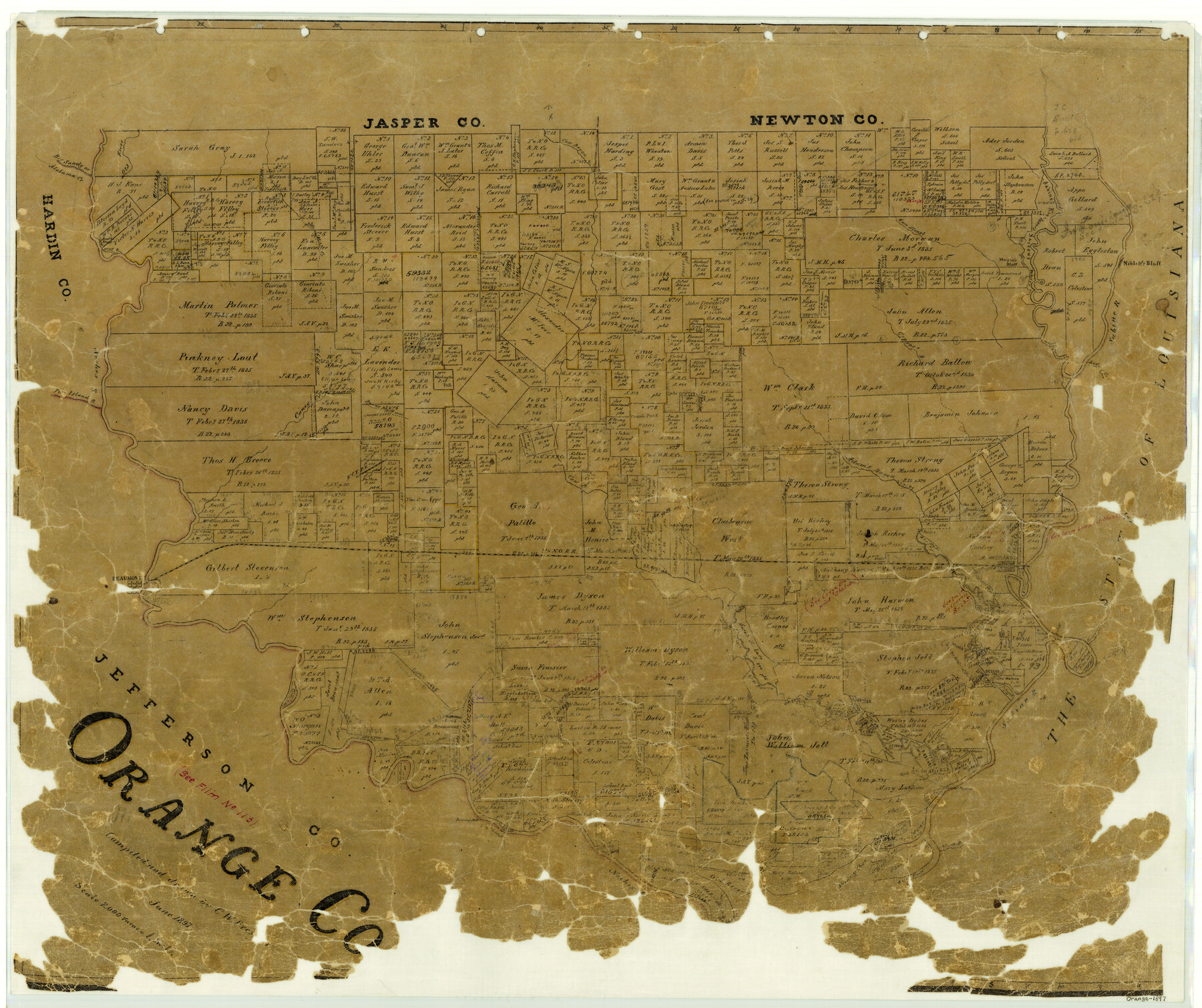
Orange County
-
Map/Doc
3928
-
Collection
General Map Collection
-
Object Dates
1897 (Creation Date)
-
People and Organizations
Texas General Land Office (Publisher)
Chas. W. Pressler (Draftsman)
Chas. W. Pressler (Compiler)
-
Counties
Orange
-
Subjects
County
-
Height x Width
24.0 x 28.6 inches
61.0 x 72.6 cm
-
Features
Hickory Cove
T&NO
Beaumont
North Bayou
Ramney's Mill
Comfort Landing
Black Bayou
West Pass [of Sabine River]
East Pass [of Sabine River]
Orange
Neches River
Dead Island
Lade's Creek
Pe[?] Island
KCS
Grigsby's Bayou
Lamar Landing
Old River
Adam's Bayou
Caney Creek
Bunn's Bluff Road
Cypress Bayou
Booth's Bluff
Walnut Creek
Ten Mile Creek
Gum Slough
Sabine River Narrows
Morgan's Bluff
Niblett's Bluff
Sabine River
Cow Bayou
Alabama Creek
Big Sandy Creek
Part of: General Map Collection
Flight Mission No. DIX-10P, Frame 80, Aransas County

Print $20.00
- Digital $50.00
Flight Mission No. DIX-10P, Frame 80, Aransas County
1956
Size 18.8 x 22.4 inches
Map/Doc 83941

Val Verde County Rolled Sketch 77

Print $20.00
- Digital $50.00
Val Verde County Rolled Sketch 77
1981
Size 36.2 x 37.4 inches
Map/Doc 10087
Flight Mission No. DAG-21K, Frame 90, Matagorda County

Print $20.00
- Digital $50.00
Flight Mission No. DAG-21K, Frame 90, Matagorda County
1952
Size 18.5 x 22.2 inches
Map/Doc 86419

Upshur County Working Sketch 14

Print $20.00
- Digital $50.00
Upshur County Working Sketch 14
Size 23.1 x 37.1 inches
Map/Doc 69571
[Corpus Christi Bay, Padre Island, Mustang Island, Laguna de la Madre, King and Kenedy's Pasture]
![73042, [Corpus Christi Bay, Padre Island, Mustang Island, Laguna de la Madre, King and Kenedy's Pasture], General Map Collection](https://historictexasmaps.com/wmedia_w700/maps/73042.tif.jpg)
Print $20.00
- Digital $50.00
[Corpus Christi Bay, Padre Island, Mustang Island, Laguna de la Madre, King and Kenedy's Pasture]
Size 26.2 x 18.2 inches
Map/Doc 73042
Andrews County Rolled Sketch 19

Print $20.00
- Digital $50.00
Andrews County Rolled Sketch 19
1945
Size 23.3 x 28.1 inches
Map/Doc 77167
Bandera County Working Sketch 38

Print $20.00
- Digital $50.00
Bandera County Working Sketch 38
1971
Size 30.4 x 31.5 inches
Map/Doc 67634
Wichita County Sketch File I

Print $4.00
- Digital $50.00
Wichita County Sketch File I
1885
Size 10.3 x 8.2 inches
Map/Doc 40091
Harris County Aerial Photograph Index Sheet 8

Print $20.00
- Digital $50.00
Harris County Aerial Photograph Index Sheet 8
1953
Size 22.2 x 16.8 inches
Map/Doc 83702
Controlled Mosaic by Jack Amman Photogrammetric Engineers, Inc - Sheet 19

Print $20.00
- Digital $50.00
Controlled Mosaic by Jack Amman Photogrammetric Engineers, Inc - Sheet 19
1954
Size 20.0 x 24.0 inches
Map/Doc 83464
You may also like
[Atlas A, Table of Contents, part 2]
![82085, [Atlas A, Table of Contents, part 2], General Map Collection](https://historictexasmaps.com/wmedia_w700/maps/82085.tif.jpg)
Print $2.00
- Digital $50.00
[Atlas A, Table of Contents, part 2]
Size 7.0 x 11.8 inches
Map/Doc 82085
Terrell County Sketch File 33

Print $20.00
- Digital $50.00
Terrell County Sketch File 33
1924
Size 18.2 x 27.6 inches
Map/Doc 12427
Deaf Smith County Working Sketch 3

Print $40.00
- Digital $50.00
Deaf Smith County Working Sketch 3
1951
Size 61.4 x 22.3 inches
Map/Doc 68643
Flight Mission No. CGI-4N, Frame 178, Cameron County

Print $20.00
- Digital $50.00
Flight Mission No. CGI-4N, Frame 178, Cameron County
1955
Size 18.6 x 22.3 inches
Map/Doc 84681
Revised Sectional Map Number 2, Showing Surveys in Howard, Martin, Andrews, Glasscock, Midland, Ector

Print $20.00
- Digital $50.00
Revised Sectional Map Number 2, Showing Surveys in Howard, Martin, Andrews, Glasscock, Midland, Ector
1908
Size 24.7 x 19.6 inches
Map/Doc 91367
Map of Presidio County, Texas

Print $40.00
- Digital $50.00
Map of Presidio County, Texas
Size 42.6 x 86.0 inches
Map/Doc 76071
Flight Mission No. DAH-17M, Frame 19, Orange County

Print $20.00
- Digital $50.00
Flight Mission No. DAH-17M, Frame 19, Orange County
1953
Size 18.6 x 22.6 inches
Map/Doc 86882
Marion County Sketch File 8

Print $4.00
- Digital $50.00
Marion County Sketch File 8
1852
Size 10.0 x 8.1 inches
Map/Doc 30575
Galveston The Year-'Round Resort

Galveston The Year-'Round Resort
1912
Size 7.8 x 10.2 inches
Map/Doc 97058
Matagorda Light to Aransas Pass

Print $20.00
- Digital $50.00
Matagorda Light to Aransas Pass
1992
Size 35.5 x 44.2 inches
Map/Doc 73405
Shelby County Sketch File 11

Print $50.00
- Digital $50.00
Shelby County Sketch File 11
1859
Size 8.8 x 7.0 inches
Map/Doc 36613
Victoria County Rolled Sketch 1

Print $20.00
- Digital $50.00
Victoria County Rolled Sketch 1
1902
Size 20.5 x 17.5 inches
Map/Doc 8150