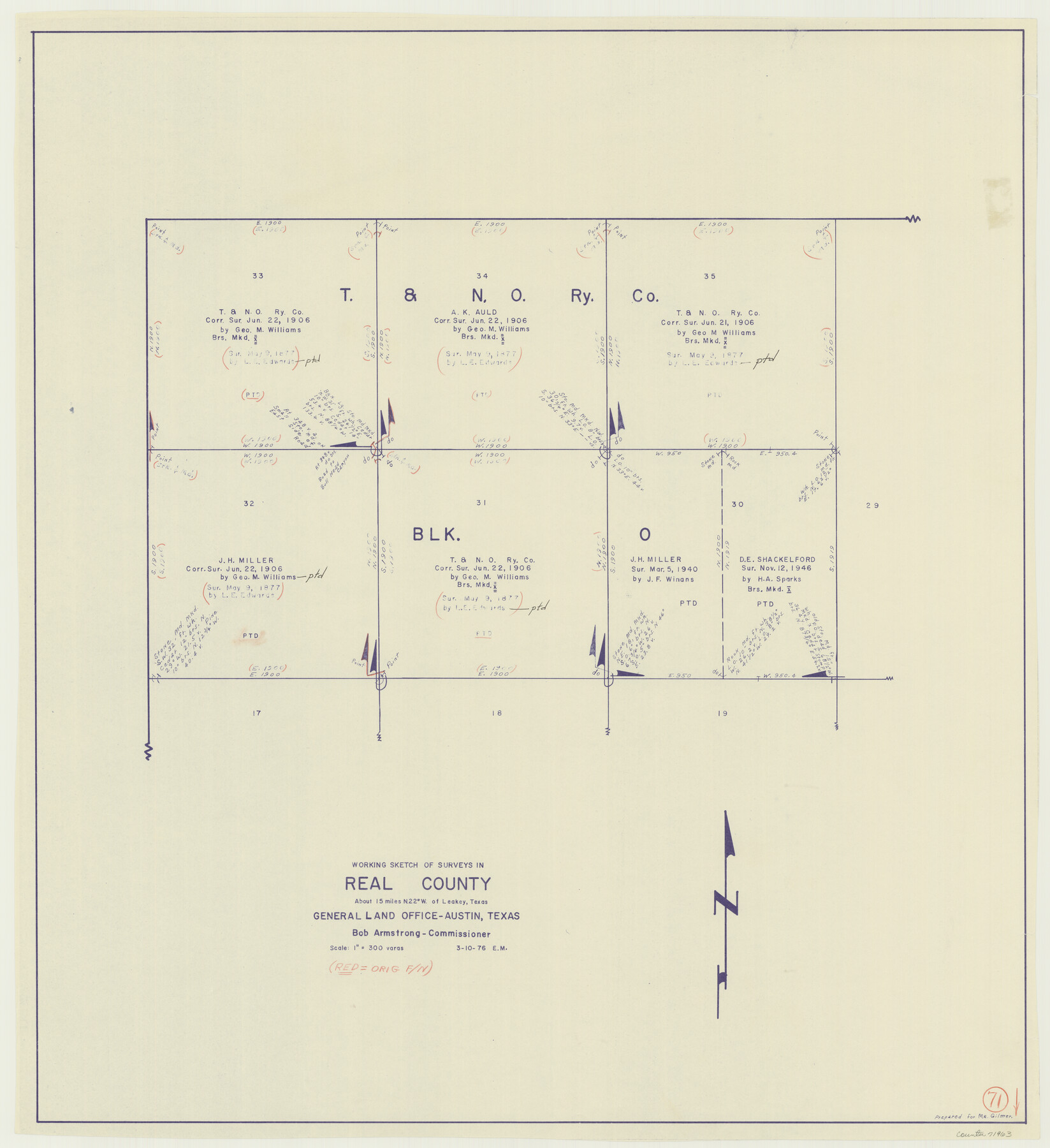
Real County Working Sketch 71
-
Map/Doc
71963
-
Collection
General Map Collection
-
Object Dates
3/10/1976 (Creation Date)
-
People and Organizations
Elbert Menzel (Draftsman)
-
Counties
Real
-
Subjects
Surveying Working Sketch
-
Height x Width
31.8 x 29.1 inches
80.8 x 73.9 cm
-
Scale
1" = 300 varas
Part of: General Map Collection
Angelina County Working Sketch 22a

Print $20.00
- Digital $50.00
Angelina County Working Sketch 22a
1953
Size 22.3 x 20.1 inches
Map/Doc 67103
El Paso County Rolled Sketch 30

Print $20.00
- Digital $50.00
El Paso County Rolled Sketch 30
1906
Size 40.9 x 22.8 inches
Map/Doc 5825
Flight Mission No. DQO-3K, Frame 20, Galveston County

Print $20.00
- Digital $50.00
Flight Mission No. DQO-3K, Frame 20, Galveston County
1952
Size 18.8 x 22.6 inches
Map/Doc 85061
Red River County Working Sketch 36

Print $20.00
- Digital $50.00
Red River County Working Sketch 36
1964
Size 42.4 x 42.7 inches
Map/Doc 72019
Colorado River, Wharton Sheet

Print $6.00
- Digital $50.00
Colorado River, Wharton Sheet
1941
Size 27.3 x 35.7 inches
Map/Doc 65314
Pecos County Working Sketch 62

Print $40.00
- Digital $50.00
Pecos County Working Sketch 62
1952
Size 32.3 x 59.1 inches
Map/Doc 71534
San Patricio County Sketch File 55

Print $14.00
- Digital $50.00
San Patricio County Sketch File 55
1999
Size 11.3 x 8.8 inches
Map/Doc 36394
Hudspeth County Working Sketch 30

Print $40.00
- Digital $50.00
Hudspeth County Working Sketch 30
Size 80.4 x 36.0 inches
Map/Doc 66313
Travis County Sketch File 50

Print $20.00
- Digital $50.00
Travis County Sketch File 50
1871
Size 18.7 x 23.5 inches
Map/Doc 12469
Orange County Working Sketch 8

Print $20.00
- Digital $50.00
Orange County Working Sketch 8
1922
Size 20.7 x 24.3 inches
Map/Doc 71340
Connected Map of Austin's Colony

Print $20.00
- Digital $50.00
Connected Map of Austin's Colony
1892
Size 46.9 x 43.5 inches
Map/Doc 76076
Harris County Sketch File 24

Print $8.00
- Digital $50.00
Harris County Sketch File 24
Size 8.8 x 8.0 inches
Map/Doc 25385
You may also like
Flight Mission No. DCL-4C, Frame 5, Kenedy County

Print $20.00
- Digital $50.00
Flight Mission No. DCL-4C, Frame 5, Kenedy County
1943
Size 18.6 x 22.3 inches
Map/Doc 85806
Calhoun County Rolled Sketch 16

Print $20.00
- Digital $50.00
Calhoun County Rolled Sketch 16
1957
Size 33.6 x 33.8 inches
Map/Doc 8549
Loving County Working Sketch 13

Print $40.00
- Digital $50.00
Loving County Working Sketch 13
1957
Size 48.4 x 34.6 inches
Map/Doc 70646
Topographical Map of the Rio Grande, Sheet No. 12

Print $20.00
- Digital $50.00
Topographical Map of the Rio Grande, Sheet No. 12
1912
Map/Doc 89536
Presidio County Rolled Sketch 43

Print $20.00
- Digital $50.00
Presidio County Rolled Sketch 43
1907
Size 31.5 x 19.7 inches
Map/Doc 7340
Presidio County Working Sketch 73

Print $20.00
- Digital $50.00
Presidio County Working Sketch 73
1962
Size 17.7 x 29.4 inches
Map/Doc 71750
Matagorda County Sketch File 37

Print $4.00
- Digital $50.00
Matagorda County Sketch File 37
Size 11.3 x 8.8 inches
Map/Doc 30830
Refugio County Sketch File 8b

Print $4.00
- Digital $50.00
Refugio County Sketch File 8b
1876
Size 8.5 x 10.5 inches
Map/Doc 35254
Rusk County Rolled Sketch 6

Print $20.00
- Digital $50.00
Rusk County Rolled Sketch 6
1949
Size 33.7 x 26.6 inches
Map/Doc 7543
Calhoun County NRC Article 33.136 Sketch 1

Print $42.00
- Digital $50.00
Calhoun County NRC Article 33.136 Sketch 1
2000
Size 16.8 x 21.7 inches
Map/Doc 61556
Liberty County Sketch File 2

Print $2.00
- Digital $50.00
Liberty County Sketch File 2
Size 7.7 x 3.3 inches
Map/Doc 29883
Rusk County Working Sketch 1

Print $20.00
- Digital $50.00
Rusk County Working Sketch 1
Size 14.2 x 23.1 inches
Map/Doc 63636