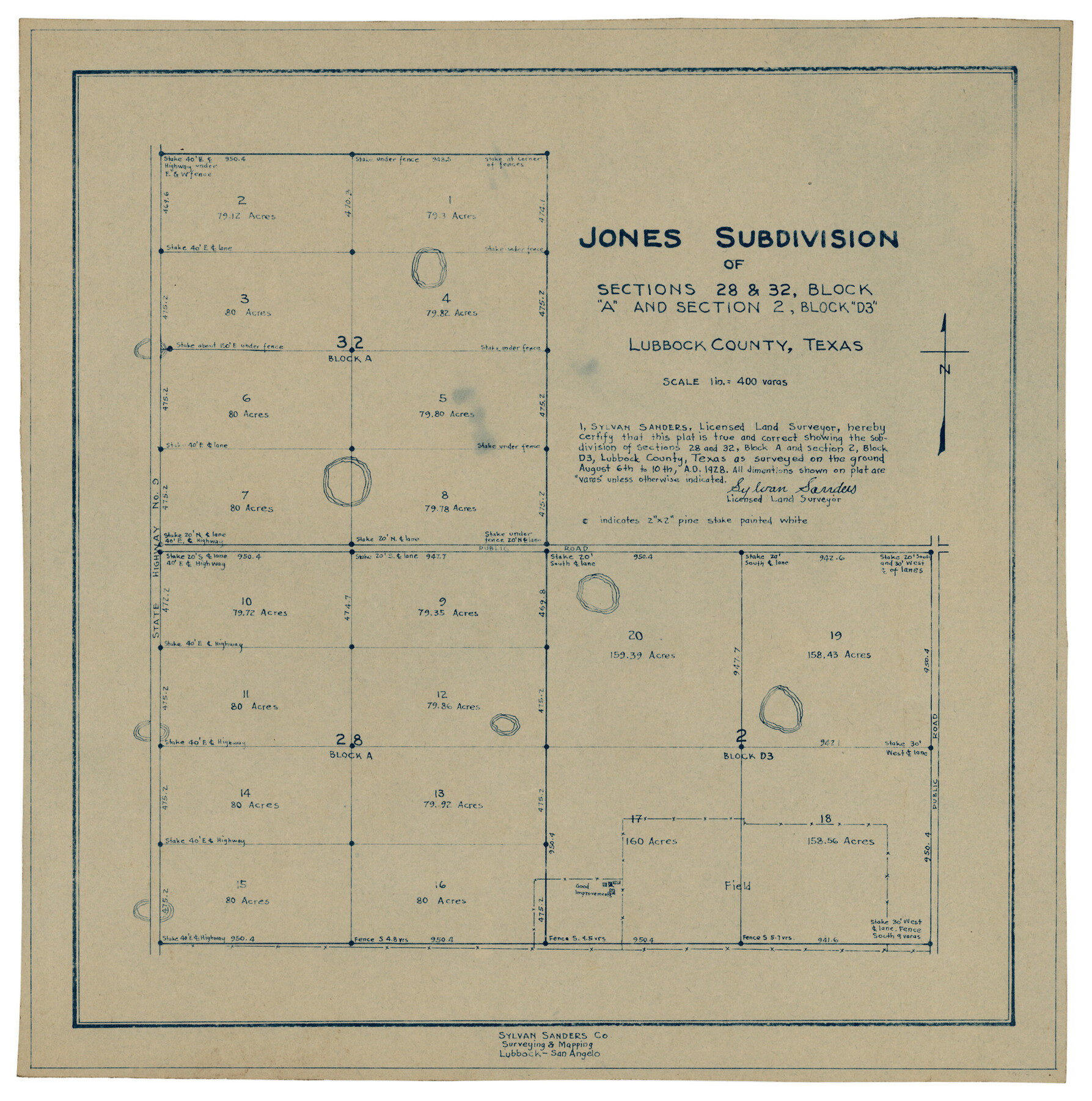
Jones Subdivision of Sections 28 and 32, Block "A' and Section 2, Block "D3"
-
Map/Doc
92708
-
Collection
Twichell Survey Records
-
Object Dates
8/10/1928 (Creation Date)
-
People and Organizations
Sylvan Sanders (Surveyor/Engineer)
-
Counties
Lubbock
-
Height x Width
8.7 x 8.7 inches
22.1 x 22.1 cm
Part of: Twichell Survey Records
[East line of Wheeler County along Oklahoma]
![89825, [East line of Wheeler County along Oklahoma], Twichell Survey Records](https://historictexasmaps.com/wmedia_w700/maps/89825-1.tif.jpg)
Print $40.00
- Digital $50.00
[East line of Wheeler County along Oklahoma]
Size 8.5 x 62.9 inches
Map/Doc 89825
[Lubbock County Sketch, Blocks D7, A, and vicinity]
![91310, [Lubbock County Sketch, Blocks D7, A, and vicinity], Twichell Survey Records](https://historictexasmaps.com/wmedia_w700/maps/91310-1.tif.jpg)
Print $20.00
- Digital $50.00
[Lubbock County Sketch, Blocks D7, A, and vicinity]
1945
Size 18.2 x 29.2 inches
Map/Doc 91310
Amarillo Improvements for Sawville-Amarillo Heights

Print $40.00
- Digital $50.00
Amarillo Improvements for Sawville-Amarillo Heights
Size 37.2 x 62.1 inches
Map/Doc 89789
Meadowbrook Villa a Subdivision in Section 77, Blk A

Print $20.00
- Digital $50.00
Meadowbrook Villa a Subdivision in Section 77, Blk A
Size 14.4 x 13.1 inches
Map/Doc 92768
[Capitol Land Leagues and Blocks M6, 10T, T1, O5 and part of Block B]
![93194, [Capitol Land Leagues and Blocks M6, 10T, T1, O5 and part of Block B], Twichell Survey Records](https://historictexasmaps.com/wmedia_w700/maps/93194-1.tif.jpg)
Print $40.00
- Digital $50.00
[Capitol Land Leagues and Blocks M6, 10T, T1, O5 and part of Block B]
Size 43.7 x 105.6 inches
Map/Doc 93194
Wellman Situated on Parts of the Northeast 1/4 and Northwest 1/4 Section 17, Block DD

Print $20.00
- Digital $50.00
Wellman Situated on Parts of the Northeast 1/4 and Northwest 1/4 Section 17, Block DD
Size 22.2 x 18.9 inches
Map/Doc 92930
[Blocks S1, O6, D10, A4]
![90702, [Blocks S1, O6, D10, A4], Twichell Survey Records](https://historictexasmaps.com/wmedia_w700/maps/90702-1.tif.jpg)
Print $20.00
- Digital $50.00
[Blocks S1, O6, D10, A4]
Size 36.5 x 28.9 inches
Map/Doc 90702
Brazos River Conservation and Reclamation District Official Boundary Line Survey

Print $20.00
- Digital $50.00
Brazos River Conservation and Reclamation District Official Boundary Line Survey
Size 36.8 x 24.8 inches
Map/Doc 90126

[Palmer, Bailey, Lamb, and Cochran Counties]
![92474, [Palmer, Bailey, Lamb, and Cochran Counties], Twichell Survey Records](https://historictexasmaps.com/wmedia_w700/maps/92474-1.tif.jpg)
Print $20.00
- Digital $50.00
[Palmer, Bailey, Lamb, and Cochran Counties]
Size 15.3 x 19.3 inches
Map/Doc 92474
Working Sketch in Eastland County

Print $20.00
- Digital $50.00
Working Sketch in Eastland County
1919
Size 20.1 x 14.6 inches
Map/Doc 90931
Capitol Syndicate Subdivision of Capitol Land Reservation Leagues Number 153, 154, 155, 156, 157, 158, 167, 168, 169, 170, 171, and 172 and Parts of Leagues 143, 144, 145, 146, 152, 159, 166, and 173

Print $20.00
- Digital $50.00
Capitol Syndicate Subdivision of Capitol Land Reservation Leagues Number 153, 154, 155, 156, 157, 158, 167, 168, 169, 170, 171, and 172 and Parts of Leagues 143, 144, 145, 146, 152, 159, 166, and 173
1908
Size 22.8 x 34.6 inches
Map/Doc 90735
You may also like
Travis County Sketch File 57

Print $8.00
- Digital $50.00
Travis County Sketch File 57
1947
Size 11.4 x 8.8 inches
Map/Doc 38402
Aransas County Rolled Sketch 15A

Print $20.00
- Digital $50.00
Aransas County Rolled Sketch 15A
1969
Size 26.3 x 25.4 inches
Map/Doc 8411
[Section 2, Block S]
![92860, [Section 2, Block S], Twichell Survey Records](https://historictexasmaps.com/wmedia_w700/maps/92860-1.tif.jpg)
Print $20.00
- Digital $50.00
[Section 2, Block S]
1958
Size 22.2 x 6.8 inches
Map/Doc 92860
Refugio County NRC Article 33.136 Sketch 1

Print $44.00
- Digital $50.00
Refugio County NRC Article 33.136 Sketch 1
2002
Size 24.5 x 36.8 inches
Map/Doc 76399
Anderson County Sketch File 14

Print $4.00
- Digital $50.00
Anderson County Sketch File 14
1857
Size 12.7 x 8.0 inches
Map/Doc 12779
Sketch of Maneuver Tract

Print $20.00
- Digital $50.00
Sketch of Maneuver Tract
1870
Size 18.5 x 14.4 inches
Map/Doc 2184
Trinity River, Branch Sheet/East Fork of Trinity River

Print $20.00
- Digital $50.00
Trinity River, Branch Sheet/East Fork of Trinity River
1931
Size 41.4 x 19.6 inches
Map/Doc 65240
Goliad County Working Sketch 16

Print $20.00
- Digital $50.00
Goliad County Working Sketch 16
1949
Size 30.0 x 46.9 inches
Map/Doc 63206
El Paso County Working Sketch 51

Print $20.00
- Digital $50.00
El Paso County Working Sketch 51
1992
Size 19.7 x 13.0 inches
Map/Doc 69073
[Texas & Pacific RR. Co. Blocks 6 and 4, L. C. Denison, Guadalupe College and vicinity]
![92133, [Texas & Pacific RR. Co. Blocks 6 and 4, L. C. Denison, Guadalupe College and vicinity], Twichell Survey Records](https://historictexasmaps.com/wmedia_w700/maps/92133-1.tif.jpg)
Print $20.00
- Digital $50.00
[Texas & Pacific RR. Co. Blocks 6 and 4, L. C. Denison, Guadalupe College and vicinity]
Size 32.5 x 19.8 inches
Map/Doc 92133
Flight Mission No. BRE-1P, Frame 4, Nueces County

Print $20.00
- Digital $50.00
Flight Mission No. BRE-1P, Frame 4, Nueces County
1956
Size 18.3 x 22.2 inches
Map/Doc 86612
Nolan County Working Sketch 4

Print $20.00
- Digital $50.00
Nolan County Working Sketch 4
1948
Size 21.6 x 28.9 inches
Map/Doc 71295