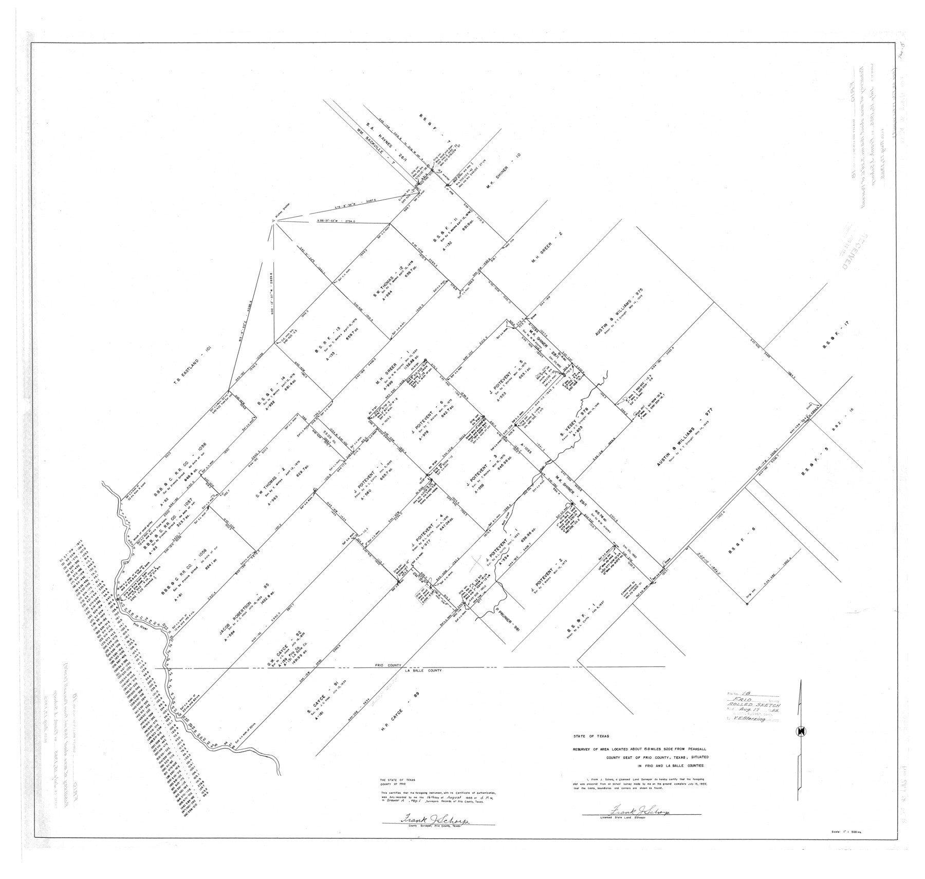
Frio County Rolled Sketch 18
Resurvey of area about 15.8 miles S20E from Pearsall, County Seat of Frio County, Texas, situated in Frio and La Salle Counties
-
Map/Doc
8908
-
Collection
General Map Collection
-
Object Dates
1955/7/15 (Creation Date)
1955/8/17 (File Date)
-
People and Organizations
Frank J. Schorp (Surveyor/Engineer)
-
Counties
Frio La Salle
-
Subjects
Surveying Rolled Sketch
-
Height x Width
41.2 x 43.4 inches
104.6 x 110.2 cm
-
Scale
1" = 500 varas
-
Comments
See Frio County Sketch File 17 (23152) for report.
Related maps
Frio County Sketch File 17

Print $6.00
- Digital $50.00
Frio County Sketch File 17
1955
Size 14.3 x 8.7 inches
Map/Doc 23152
Part of: General Map Collection
[St. L. S-W. Ry. Of Texas Map of Lufkin Branch in Cherokee County Texas]
![64022, [St. L. S-W. Ry. Of Texas Map of Lufkin Branch in Cherokee County Texas], General Map Collection](https://historictexasmaps.com/wmedia_w700/maps/64022.tif.jpg)
Print $40.00
- Digital $50.00
[St. L. S-W. Ry. Of Texas Map of Lufkin Branch in Cherokee County Texas]
1912
Size 23.1 x 122.7 inches
Map/Doc 64022
Washington County Working Sketch 3

Print $20.00
- Digital $50.00
Washington County Working Sketch 3
1992
Size 31.5 x 42.7 inches
Map/Doc 72364
Flight Mission No. BRA-7M, Frame 42, Jefferson County

Print $20.00
- Digital $50.00
Flight Mission No. BRA-7M, Frame 42, Jefferson County
1953
Size 18.6 x 22.3 inches
Map/Doc 85493
Hardeman County Boundary File 3a

Print $42.00
- Digital $50.00
Hardeman County Boundary File 3a
Size 56.8 x 12.3 inches
Map/Doc 54384
Jefferson County Working Sketch 23

Print $20.00
- Digital $50.00
Jefferson County Working Sketch 23
1970
Size 23.9 x 29.2 inches
Map/Doc 66566
Collingsworth County

Print $20.00
- Digital $50.00
Collingsworth County
1880
Size 24.9 x 20.0 inches
Map/Doc 3420
Map of the East Part of Tom Green County

Print $20.00
- Digital $50.00
Map of the East Part of Tom Green County
1894
Size 21.5 x 23.1 inches
Map/Doc 4083

Gradient Boundary Survey of Canadian River through portions of Hutchinson & Roberts Counties, Texas

Print $40.00
- Digital $50.00
Gradient Boundary Survey of Canadian River through portions of Hutchinson & Roberts Counties, Texas
1989
Size 39.6 x 139.0 inches
Map/Doc 3120
Liberty County Working Sketch 7

Print $20.00
- Digital $50.00
Liberty County Working Sketch 7
1906
Size 22.2 x 24.8 inches
Map/Doc 70466
Montgomery County Sketch File 4

Print $8.00
- Digital $50.00
Montgomery County Sketch File 4
1854
Size 12.0 x 8.1 inches
Map/Doc 31775
Kendall County

Print $20.00
- Digital $50.00
Kendall County
1946
Size 41.1 x 35.3 inches
Map/Doc 77336
You may also like
America siue India Nova ad magnae Gerardi Mercatoris aui Vniversalis imitationem in compendium redacta

Print $20.00
- Digital $50.00
America siue India Nova ad magnae Gerardi Mercatoris aui Vniversalis imitationem in compendium redacta
1585
Size 16.9 x 20.2 inches
Map/Doc 93808
[Surveys in Power and Hewetson's Colony along the Blanco and Medina Rivers]
![46, [Surveys in Power and Hewetson's Colony along the Blanco and Medina Rivers], General Map Collection](https://historictexasmaps.com/wmedia_w700/maps/46.tif.jpg)
Print $20.00
- Digital $50.00
[Surveys in Power and Hewetson's Colony along the Blanco and Medina Rivers]
1834
Size 37.0 x 29.9 inches
Map/Doc 46
Harris County Historic Topographic 28

Print $20.00
- Digital $50.00
Harris County Historic Topographic 28
1915
Size 29.5 x 22.8 inches
Map/Doc 65839
Goliad County Sketch File 38

Print $4.00
- Digital $50.00
Goliad County Sketch File 38
1859
Size 13.0 x 8.1 inches
Map/Doc 24338
Brazos River Conservation and Reclamation District Official Boundary Line Survey

Print $20.00
- Digital $50.00
Brazos River Conservation and Reclamation District Official Boundary Line Survey
1931
Size 25.1 x 36.9 inches
Map/Doc 90125
Concho County Sketch File 30

Print $20.00
- Digital $50.00
Concho County Sketch File 30
1858
Size 13.8 x 20.4 inches
Map/Doc 11156
Yoakum County

Print $20.00
- Digital $50.00
Yoakum County
1938
Size 24.9 x 24.6 inches
Map/Doc 92446
Map of Texas with population and location of principal towns and cities according to latest reliable statistics

Print $20.00
- Digital $50.00
Map of Texas with population and location of principal towns and cities according to latest reliable statistics
1908
Size 18.5 x 20.4 inches
Map/Doc 95873
Montague County Sketch File 11

Print $4.00
- Digital $50.00
Montague County Sketch File 11
1873
Size 12.2 x 8.4 inches
Map/Doc 31734

The Republic County of Austin. January 29, 1842

Print $20.00
The Republic County of Austin. January 29, 1842
2020
Size 14.7 x 21.7 inches
Map/Doc 96086
Dimmit County Sketch File 48

Print $20.00
- Digital $50.00
Dimmit County Sketch File 48
1909
Size 17.9 x 19.3 inches
Map/Doc 11357