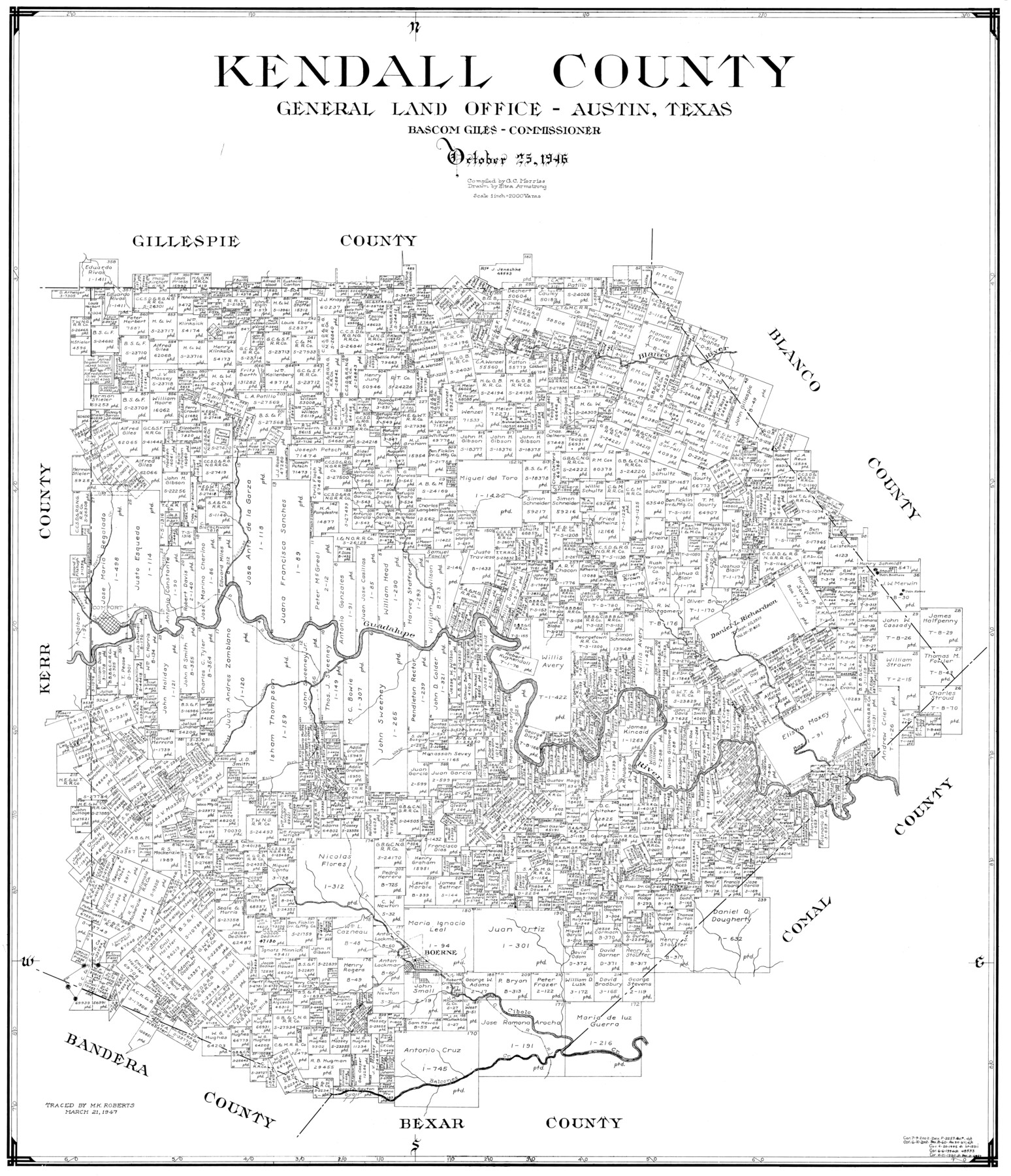
Kendall County
-
Map/Doc
77336
-
Collection
General Map Collection
-
Object Dates
1946/10/25 (Creation Date)
-
People and Organizations
Eltea Armstrong (Draftsman)
G.C. Morriss (Compiler)
-
Counties
Kendall
-
Subjects
County
-
Height x Width
41.1 x 35.3 inches
104.4 x 89.7 cm
Part of: General Map Collection
Victoria County Sketch File 2

Print $7.00
- Digital $50.00
Victoria County Sketch File 2
1873
Size 10.3 x 8.4 inches
Map/Doc 39511
Dawson County Sketch File C

Print $50.00
- Digital $50.00
Dawson County Sketch File C
1917
Size 14.3 x 8.8 inches
Map/Doc 20470
Garza County Sketch File 11

Print $4.00
- Digital $50.00
Garza County Sketch File 11
1901
Size 11.3 x 8.8 inches
Map/Doc 24066
Brooks County Sketch File 1

Print $12.00
- Digital $50.00
Brooks County Sketch File 1
1923
Size 14.3 x 8.9 inches
Map/Doc 16537
Lubbock County Boundary File 9

Print $55.00
- Digital $50.00
Lubbock County Boundary File 9
Size 17.0 x 11.0 inches
Map/Doc 56530
Hamilton County Working Sketch 22

Print $20.00
- Digital $50.00
Hamilton County Working Sketch 22
1955
Size 41.6 x 19.0 inches
Map/Doc 63360
Terrell County Rolled Sketch 49

Print $20.00
- Digital $50.00
Terrell County Rolled Sketch 49
1962
Size 17.3 x 24.1 inches
Map/Doc 7951
Hale County Sketch File E

Print $20.00
- Digital $50.00
Hale County Sketch File E
1902
Size 15.2 x 21.5 inches
Map/Doc 11601
Crockett County Rolled Sketch 19
Print $40.00
- Digital $50.00
Crockett County Rolled Sketch 19
1901
Size 28.2 x 64.2 inches
Map/Doc 8691
Outer Continental Shelf Leasing Maps (Louisiana Offshore Operations)

Print $20.00
- Digital $50.00
Outer Continental Shelf Leasing Maps (Louisiana Offshore Operations)
1959
Size 13.7 x 17.4 inches
Map/Doc 76116
Wood County Working Sketch 19

Print $20.00
- Digital $50.00
Wood County Working Sketch 19
1982
Size 25.8 x 24.8 inches
Map/Doc 62019
Comanche County Milam Land District

Print $20.00
- Digital $50.00
Comanche County Milam Land District
1876
Size 22.1 x 23.0 inches
Map/Doc 3433
You may also like
Calhoun County Rolled Sketch 9

Print $20.00
- Digital $50.00
Calhoun County Rolled Sketch 9
Size 24.4 x 38.7 inches
Map/Doc 5365
Hutchinson County Rolled Sketch 44-5

Print $20.00
- Digital $50.00
Hutchinson County Rolled Sketch 44-5
2002
Size 24.0 x 36.0 inches
Map/Doc 77541
Aransas County NRC Article 33.136 Sketch 1

Print $55.00
- Digital $50.00
Aransas County NRC Article 33.136 Sketch 1
2000
Size 24.8 x 35.6 inches
Map/Doc 61630
Flight Mission No. DIX-6P, Frame 111, Aransas County

Print $20.00
- Digital $50.00
Flight Mission No. DIX-6P, Frame 111, Aransas County
1956
Size 18.9 x 22.6 inches
Map/Doc 83817
Pecos County Rolled Sketch 146C

Print $20.00
- Digital $50.00
Pecos County Rolled Sketch 146C
Size 43.1 x 39.5 inches
Map/Doc 9743
Map of the State of Texas

Print $40.00
- Digital $50.00
Map of the State of Texas
1879
Size 102.7 x 106.6 inches
Map/Doc 16973
Montgomery County Sketch File 37

Print $6.00
- Digital $50.00
Montgomery County Sketch File 37
Size 12.6 x 8.2 inches
Map/Doc 31916
Marion County Working Sketch 7

Print $20.00
- Digital $50.00
Marion County Working Sketch 7
1918
Size 27.9 x 27.7 inches
Map/Doc 70782

Liberty County Working Sketch 30

Print $20.00
- Digital $50.00
Liberty County Working Sketch 30
1943
Size 18.5 x 20.6 inches
Map/Doc 70489
Kerr County Rolled Sketch 4

Print $20.00
- Digital $50.00
Kerr County Rolled Sketch 4
Size 21.8 x 23.1 inches
Map/Doc 6493
Bosque County Sketch File 16

Print $14.00
- Digital $50.00
Bosque County Sketch File 16
Size 13.0 x 7.9 inches
Map/Doc 14781