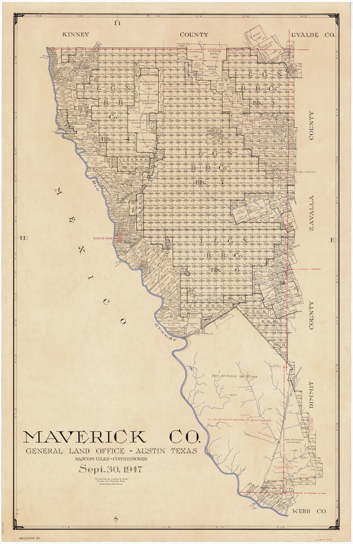
Maverick Co.
-
Map/Doc
73233
-
Collection
General Map Collection
-
Object Dates
1947/9/30 (Creation Date)
-
People and Organizations
Texas General Land Office (Publisher)
Tommye Buie (Draftsman)
Bascom Giles (GLO Commissioner)
Curtis R. Hale (Compiler)
-
Counties
Maverick
-
Subjects
County
-
Height x Width
47.4 x 31.0 inches
120.4 x 78.7 cm
-
Comments
Hand lettered.
Note on reverse side: "Compilation completed September 30, 1947. Inking completed October 25, 1948. Tracing completed April 6, 1949. Placed in official use April 13, 1949." -
Features
Rosita de San Juan Creek
Comanche Creek
Guajalote Creek
Tinaja Creek
Willow Creek
Cuevas Creek
Viper Creek
Walls Road
Rosita de San Juan
Indio Lake
Palo Blanco Creek
Rosita Creek
Paquache Pass
Cueva Creek
San Pedro Creek
San Pedro Spring
San Ambrosia Pass
Arroyo Taza
San Pablo Creek
Cathedral Rock
San Ambrosia Creek
Penitas de Abajo [Creek]
Live Oak Creek
Chacon Creek
Muela Creek
Chaparosa Creek
Labro Creek
Cañon Grande [Creek]
Las Moras Creek
Rio San Rodriques [sic]
Saus Creek
Southern Pacific Railroad Company
Barrera Creek
Rio San Diego
Salado Creek
Pierro Bravo Creek
Elm Creek
American Creek
Rio Grande
Las Chimneas Creek
Picoso Creek
Eagle Pass
Rio Escondido
Part of: General Map Collection
Dawson County Sketch File 23

Print $4.00
- Digital $50.00
Dawson County Sketch File 23
Size 9.2 x 11.5 inches
Map/Doc 20575
University Lands, Blocks 38 to 57, Crockett, Reagan, Irion, Schleicher Counties

Print $40.00
- Digital $50.00
University Lands, Blocks 38 to 57, Crockett, Reagan, Irion, Schleicher Counties
Size 34.0 x 53.0 inches
Map/Doc 62946
Hemphill County

Print $20.00
- Digital $50.00
Hemphill County
1932
Size 39.5 x 37.5 inches
Map/Doc 77309
San Augustine County Sketch File 1

Print $4.00
San Augustine County Sketch File 1
1849
Size 9.3 x 8.2 inches
Map/Doc 35631
Anderson County Working Sketch 6

Print $20.00
- Digital $50.00
Anderson County Working Sketch 6
1913
Size 24.7 x 26.3 inches
Map/Doc 67005
[Surveys in the Jefferson District]
![69726, [Surveys in the Jefferson District], General Map Collection](https://historictexasmaps.com/wmedia_w700/maps/69726-1.tif.jpg)
Print $20.00
- Digital $50.00
[Surveys in the Jefferson District]
1841
Size 14.6 x 21.2 inches
Map/Doc 69726
Culberson County Rolled Sketch 27

Print $20.00
- Digital $50.00
Culberson County Rolled Sketch 27
1922
Size 26.8 x 34.9 inches
Map/Doc 5656
Erath County Working Sketch 50a

Print $20.00
- Digital $50.00
Erath County Working Sketch 50a
Size 43.2 x 37.0 inches
Map/Doc 69131
Right of Way and Track Map of The Missouri, Kansas & Texas Railway of Texas

Print $40.00
- Digital $50.00
Right of Way and Track Map of The Missouri, Kansas & Texas Railway of Texas
1918
Size 25.9 x 108.3 inches
Map/Doc 64526
Montgomery County Sketch File 41

Print $8.00
- Digital $50.00
Montgomery County Sketch File 41
2004
Size 14.0 x 8.5 inches
Map/Doc 82447
Flight Mission No. DCL-7C, Frame 134, Kenedy County

Print $20.00
- Digital $50.00
Flight Mission No. DCL-7C, Frame 134, Kenedy County
1943
Size 18.5 x 22.3 inches
Map/Doc 86091
[Surveys near the city of Bastrop]
![107, [Surveys near the city of Bastrop], General Map Collection](https://historictexasmaps.com/wmedia_w700/maps/107.tif.jpg)
Print $2.00
- Digital $50.00
[Surveys near the city of Bastrop]
1841
Size 6.5 x 7.0 inches
Map/Doc 107
You may also like
Harris County Working Sketch 115

Print $40.00
- Digital $50.00
Harris County Working Sketch 115
1983
Size 48.8 x 44.5 inches
Map/Doc 66007
I. & G. N. - International and Great Northern R.R. - International Route - Galveston, Ft. Worth, Waco, Houston, Austin, Laredo, San Antonio

Print $20.00
- Digital $50.00
I. & G. N. - International and Great Northern R.R. - International Route - Galveston, Ft. Worth, Waco, Houston, Austin, Laredo, San Antonio
1905
Size 23.5 x 15.8 inches
Map/Doc 95778
Milam County Sketch File 9

Print $4.00
- Digital $50.00
Milam County Sketch File 9
1873
Size 12.8 x 8.2 inches
Map/Doc 31639
Montague County Working Sketch 34

Print $20.00
- Digital $50.00
Montague County Working Sketch 34
1979
Size 20.3 x 15.0 inches
Map/Doc 71100
[Surveys near the city of Bastrop]
Print $2.00
- Digital $50.00
[Surveys near the city of Bastrop]
1841
Size 6.5 x 7.0 inches
Map/Doc 107
Angelina County Rolled Sketch 3

Print $20.00
- Digital $50.00
Angelina County Rolled Sketch 3
Size 25.9 x 42.5 inches
Map/Doc 77186
Tom Green County Sketch File 50

Print $20.00
- Digital $50.00
Tom Green County Sketch File 50
1884
Size 25.4 x 34.5 inches
Map/Doc 12442
Renderbrook Ranch

Print $20.00
- Digital $50.00
Renderbrook Ranch
1932
Size 16.9 x 13.5 inches
Map/Doc 92279
Map of Franklin County, Texas

Print $20.00
- Digital $50.00
Map of Franklin County, Texas
1879
Size 23.4 x 11.3 inches
Map/Doc 728
Lamar County Sketch File 13

Print $2.00
- Digital $50.00
Lamar County Sketch File 13
1943
Size 10.9 x 8.0 inches
Map/Doc 29307
McLennan County Sketch File 30

Print $4.00
- Digital $50.00
McLennan County Sketch File 30
Size 8.4 x 7.4 inches
Map/Doc 31304
Kleberg County Rolled Sketch 10-35

Print $20.00
- Digital $50.00
Kleberg County Rolled Sketch 10-35
1952
Size 38.2 x 35.4 inches
Map/Doc 9366