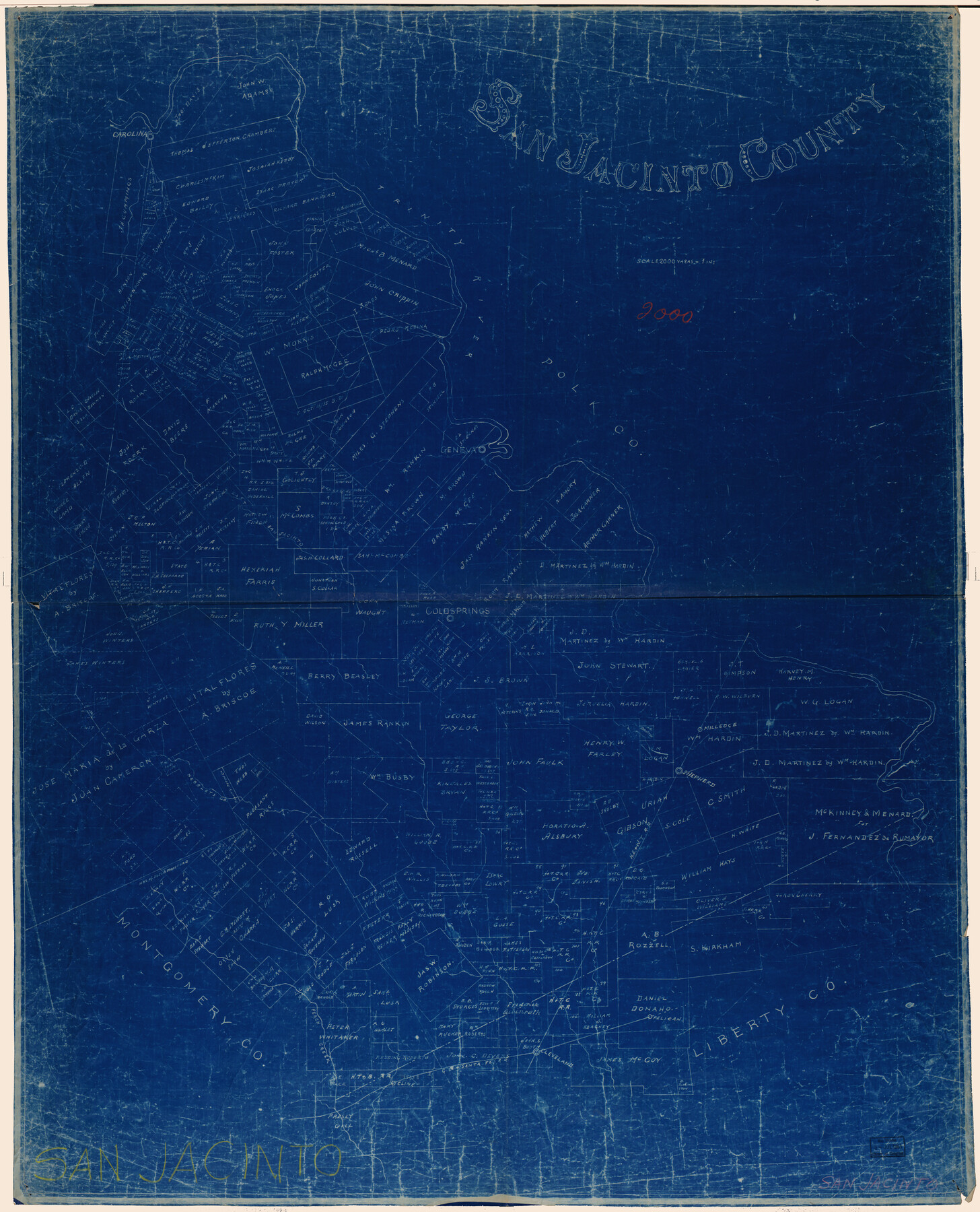
San Jacinto County
-
Map/Doc
88992
-
Collection
Library of Congress
-
Counties
San Jacinto
-
Subjects
County
-
Height x Width
43.3 x 35.0 inches
110.0 x 88.9 cm
-
Comments
For more information see here. Prints available from the GLO courtesy of Library of Congress, Geography and Map Division.
Part of: Library of Congress
Neue Karte de Staates Texas für 1881.

Print $20.00
Neue Karte de Staates Texas für 1881.
1881
Size 19.3 x 25.6 inches
Map/Doc 93573
The Santa Fe Route and connections

Print $20.00
The Santa Fe Route and connections
1888
Size 15.4 x 24.8 inches
Map/Doc 96972
Waco, Tex., County Seat of McLennan Co.

Print $20.00
Waco, Tex., County Seat of McLennan Co.
1886
Size 16.9 x 30.7 inches
Map/Doc 93473
Map of Glasscock County, Texas

Print $20.00
Map of Glasscock County, Texas
Size 22.7 x 18.3 inches
Map/Doc 88943
Map of the city of Fort Worth and vicinity

Print $20.00
Map of the city of Fort Worth and vicinity
Size 38.6 x 25.9 inches
Map/Doc 93557


Map of the military dep't of Texas : being a section of the map of the territory of the U.S. from the Mississippi River to the Pacific Ocean

Print $20.00
Map of the military dep't of Texas : being a section of the map of the territory of the U.S. from the Mississippi River to the Pacific Ocean
1859
Size 20.9 x 24.0 inches
Map/Doc 93596

Hardeman Co[unty], Texas
![88946, Hardeman Co[unty], Texas, Library of Congress](https://historictexasmaps.com/wmedia_w700/maps/88946.tif.jpg)
Print $20.00
Hardeman Co[unty], Texas
1880
Size 27.8 x 23.7 inches
Map/Doc 88946
Panorama of the seat of war - Birds eye view of Texas and part of Mexico

Print $20.00
Panorama of the seat of war - Birds eye view of Texas and part of Mexico
1861
Size 21.6 x 28.9 inches
Map/Doc 93360

You may also like
Childress County Sketch File 14

Print $12.00
- Digital $50.00
Childress County Sketch File 14
1896
Size 9.8 x 6.3 inches
Map/Doc 18272
Bailey County

Print $40.00
- Digital $50.00
Bailey County
1956
Size 49.4 x 31.4 inches
Map/Doc 95423
Tyler County Sketch File 13

Print $6.00
- Digital $50.00
Tyler County Sketch File 13
1857
Size 8.7 x 13.0 inches
Map/Doc 38653
Survey of 77 Blocks, State University Land

Survey of 77 Blocks, State University Land
1884
Size 13.5 x 8.5 inches
Map/Doc 81693
Newton County Rolled Sketch 14

Print $40.00
- Digital $50.00
Newton County Rolled Sketch 14
1953
Size 33.4 x 56.0 inches
Map/Doc 9579
Culberson County Rolled Sketch 15

Print $20.00
- Digital $50.00
Culberson County Rolled Sketch 15
1904
Size 30.5 x 40.2 inches
Map/Doc 8744
Stonewall County Rolled Sketch 20

Print $40.00
- Digital $50.00
Stonewall County Rolled Sketch 20
Size 36.7 x 55.7 inches
Map/Doc 49129
Coleman County Working Sketch 14
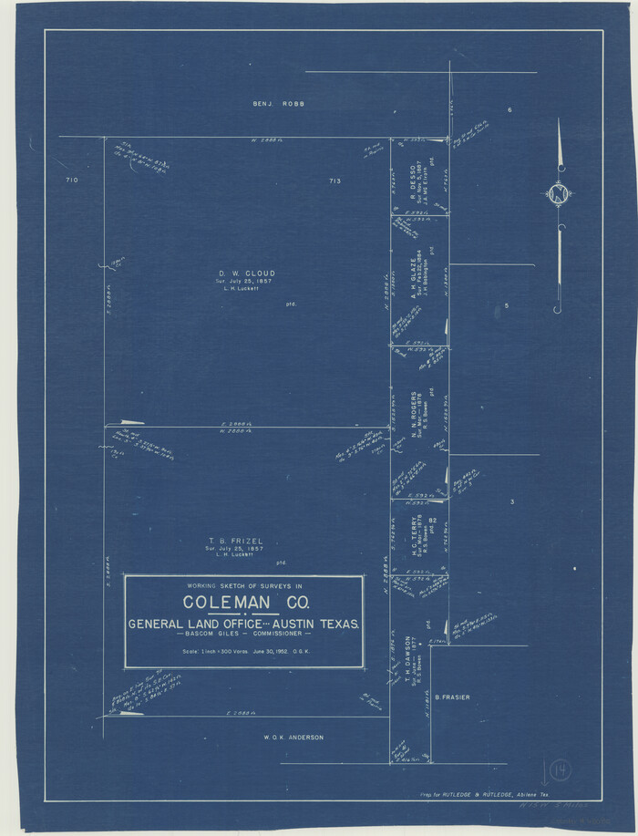
Print $20.00
- Digital $50.00
Coleman County Working Sketch 14
1952
Size 27.8 x 21.2 inches
Map/Doc 68080
Counties of Martin, Dawson, Borden, Howard, Texas, Soash Lands, Big Spring Ranch

Print $20.00
- Digital $50.00
Counties of Martin, Dawson, Borden, Howard, Texas, Soash Lands, Big Spring Ranch
Size 34.7 x 36.9 inches
Map/Doc 93006
Brooks County Rolled Sketch 20

Print $20.00
- Digital $50.00
Brooks County Rolled Sketch 20
1943
Size 27.0 x 26.4 inches
Map/Doc 5342
Stonewall County Sketch File 5

Print $40.00
- Digital $50.00
Stonewall County Sketch File 5
Size 14.9 x 14.4 inches
Map/Doc 37206
Dickens County Sketch File M

Print $59.00
- Digital $50.00
Dickens County Sketch File M
1908
Size 14.6 x 9.1 inches
Map/Doc 20911