Stonewall County Sketch File 5
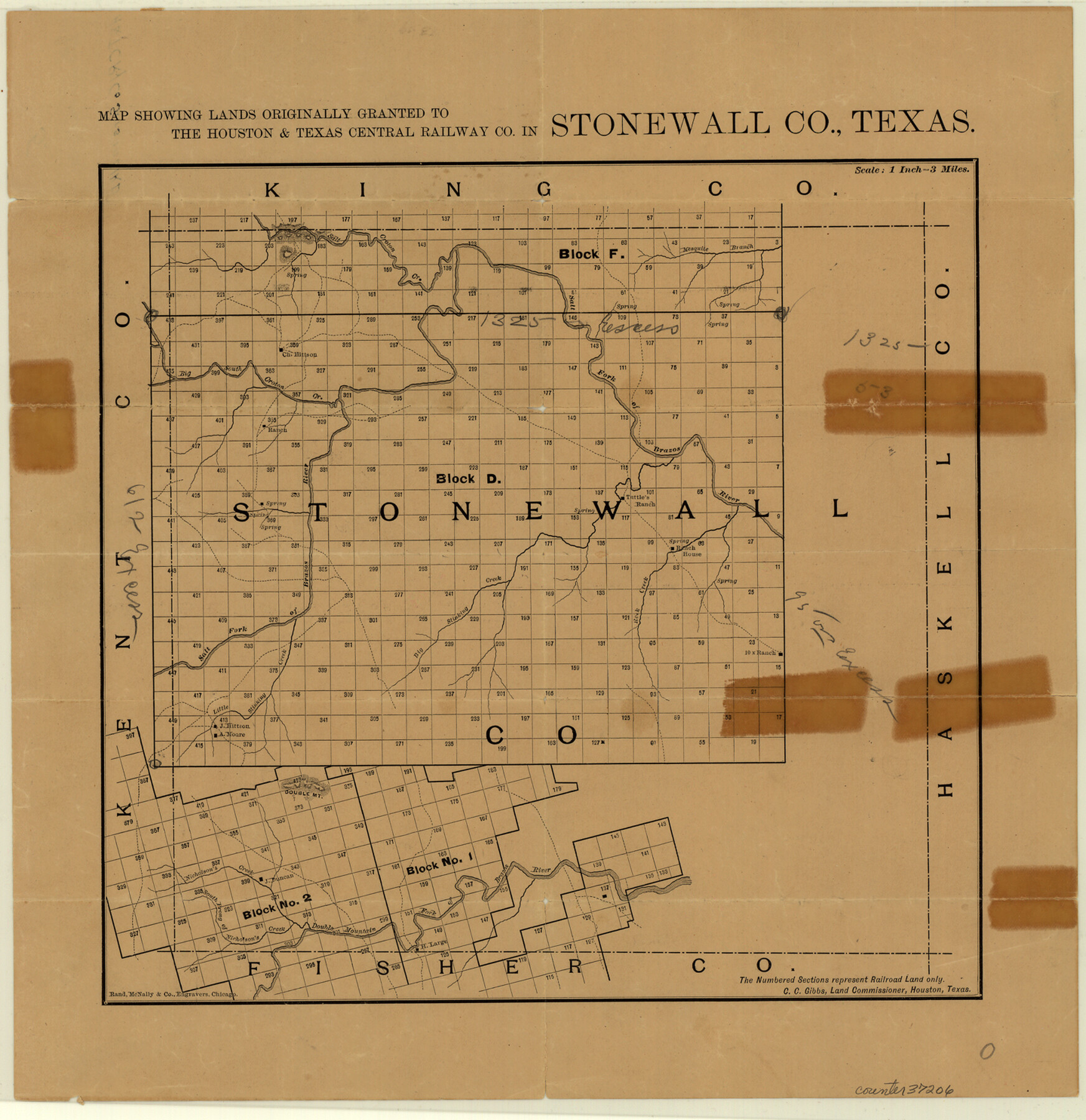
Map showing lands originally granted to the Houston & Texas Central Railway Co. in Stonewall Co., Texas
-
Map/Doc
37206
-
Collection
General Map Collection
-
People and Organizations
Rand McNally & Co. (Engraver)
-
Counties
Stonewall King Kent Fisher
-
Subjects
Surveying Sketch File
-
Height x Width
14.9 x 14.4 inches
37.9 x 36.6 cm
-
Medium
paper, etching/engraving/lithograph
-
Scale
1" = 3 miles
-
Features
Mesquite Branch
Croton Creek
Big South Croton Creek
Salt Fork of Brazos River
Tattle's Ranch
Rock Creek
Big Stinking Creek
Little Stinking Creek
Nicholson's Creek
Double Mountain Fork of Brazos River
Double Mountain
South Prong of Nicholson's Creek
H. Large House
Part of: General Map Collection
Flight Mission No. DAG-18K, Frame 72, Matagorda County

Print $20.00
- Digital $50.00
Flight Mission No. DAG-18K, Frame 72, Matagorda County
1952
Size 18.5 x 22.2 inches
Map/Doc 86365
Carte du Mexique et de la Floride des Terres Angloises et des Isles Antilles du Cours et des Environs de la Riviere Mississipi

Print $20.00
- Digital $50.00
Carte du Mexique et de la Floride des Terres Angloises et des Isles Antilles du Cours et des Environs de la Riviere Mississipi
1703
Size 21.8 x 30.0 inches
Map/Doc 94852
Webb County Sketch File 11a-1

Print $27.00
- Digital $50.00
Webb County Sketch File 11a-1
1884
Size 22.2 x 9.3 inches
Map/Doc 12626
Sutton County Working Sketch 47

Print $20.00
- Digital $50.00
Sutton County Working Sketch 47
1954
Size 34.3 x 21.3 inches
Map/Doc 62390
Nueces County NRC Article 33.136 Sketch 12

Print $80.00
- Digital $50.00
Nueces County NRC Article 33.136 Sketch 12
2000
Size 24.9 x 36.7 inches
Map/Doc 83065
Pecos County Sketch File 40

Print $30.00
- Digital $50.00
Pecos County Sketch File 40
1919
Size 14.6 x 9.2 inches
Map/Doc 33722
Culberson County Working Sketch 19

Print $20.00
- Digital $50.00
Culberson County Working Sketch 19
1933
Size 30.0 x 43.6 inches
Map/Doc 68471
Flight Mission No. CRC-4R, Frame 81, Chambers County

Print $20.00
- Digital $50.00
Flight Mission No. CRC-4R, Frame 81, Chambers County
1956
Size 18.7 x 22.5 inches
Map/Doc 84885
Origin of Exports and Destination of Imports at Galveston during 1921

Print $20.00
- Digital $50.00
Origin of Exports and Destination of Imports at Galveston during 1921
1921
Size 13.7 x 19.9 inches
Map/Doc 97168
Coke County Working Sketch 6

Print $20.00
- Digital $50.00
Coke County Working Sketch 6
1914
Size 19.1 x 15.7 inches
Map/Doc 68043
Flight Mission No. DCL-7C, Frame 136, Kenedy County

Print $20.00
- Digital $50.00
Flight Mission No. DCL-7C, Frame 136, Kenedy County
1943
Size 18.6 x 22.3 inches
Map/Doc 86093
Newton County Sketch File 4a

Print $4.00
- Digital $50.00
Newton County Sketch File 4a
Size 12.6 x 8.0 inches
Map/Doc 32362
You may also like
Montgomery County Sketch File 9

Print $6.00
- Digital $50.00
Montgomery County Sketch File 9
Size 9.0 x 7.6 inches
Map/Doc 31795
Ochiltree County Sketch File 2

Print $38.00
- Digital $50.00
Ochiltree County Sketch File 2
1903
Size 11.3 x 8.6 inches
Map/Doc 33168
Angelina County Sketch File 15

Print $8.00
- Digital $50.00
Angelina County Sketch File 15
1848
Size 12.5 x 7.5 inches
Map/Doc 12960
Jack County Working Sketch 15

Print $20.00
- Digital $50.00
Jack County Working Sketch 15
1982
Size 30.6 x 25.9 inches
Map/Doc 66441
Map of Giddings

Print $20.00
- Digital $50.00
Map of Giddings
1940
Size 16.5 x 21.2 inches
Map/Doc 2210

Houston County Working Sketch 24

Print $40.00
- Digital $50.00
Houston County Working Sketch 24
1983
Size 43.9 x 77.2 inches
Map/Doc 66254
Stephens County

Print $20.00
- Digital $50.00
Stephens County
1940
Size 40.3 x 38.9 inches
Map/Doc 77426
Reagan County Working Sketch 30

Print $40.00
- Digital $50.00
Reagan County Working Sketch 30
1963
Size 31.9 x 57.3 inches
Map/Doc 71872
Upshur County Sketch File 22

Print $8.00
- Digital $50.00
Upshur County Sketch File 22
2015
Size 11.0 x 8.5 inches
Map/Doc 93774
[Blocks 2, 3, 4, 7, and B2]
![90754, [Blocks 2, 3, 4, 7, and B2], Twichell Survey Records](https://historictexasmaps.com/wmedia_w700/maps/90754-1.tif.jpg)
Print $20.00
- Digital $50.00
[Blocks 2, 3, 4, 7, and B2]
1882
Size 20.0 x 25.6 inches
Map/Doc 90754
Palo Pinto County Boundary File 1

Print $4.00
- Digital $50.00
Palo Pinto County Boundary File 1
Size 12.8 x 8.4 inches
Map/Doc 57789