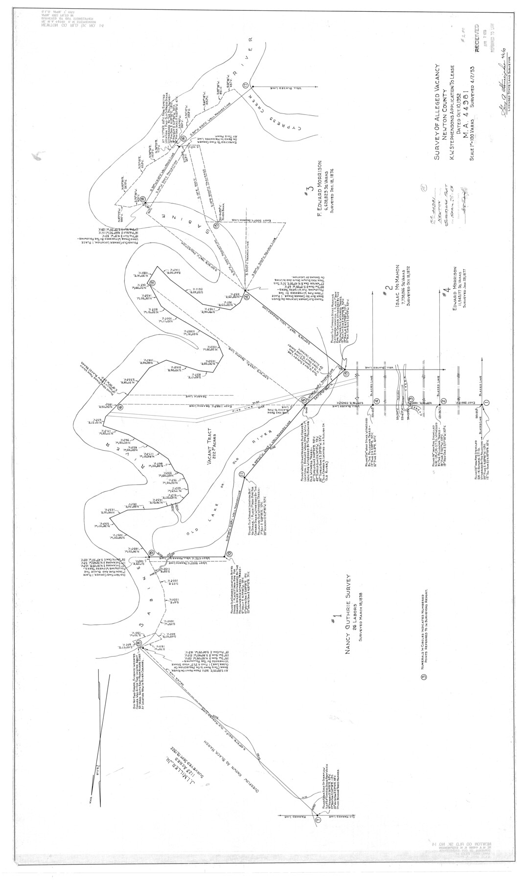
Newton County Rolled Sketch 14
Survey of alleged vacancy, Newton County, K.W. Stephensons application to lease dated Oct. 10, 1952, MA-44981
-
Map/Doc
9579
-
Collection
General Map Collection
-
Object Dates
4/2/1953 (Creation Date)
4/7/1953 (File Date)
-
People and Organizations
Guy A. Stonecipher (Surveyor/Engineer)
-
Counties
Newton
-
Subjects
Surveying Rolled Sketch
-
Height x Width
33.4 x 56.0 inches
84.8 x 142.2 cm
-
Scale
1" = 100 varas
Part of: General Map Collection
Bosque County Sketch File 20

Print $4.00
- Digital $50.00
Bosque County Sketch File 20
1863
Size 11.8 x 7.7 inches
Map/Doc 14796
San Patricio County Sketch File 53

Print $12.00
- Digital $50.00
San Patricio County Sketch File 53
1995
Size 11.3 x 8.8 inches
Map/Doc 36388
Bastrop County Boundary File 4

Print $48.00
- Digital $50.00
Bastrop County Boundary File 4
1925
Size 11.2 x 8.7 inches
Map/Doc 50324
Tom Green County Sketch File 68

Print $20.00
- Digital $50.00
Tom Green County Sketch File 68
1913
Size 30.8 x 41.5 inches
Map/Doc 10406
Gillespie County Sketch File 3

Print $4.00
- Digital $50.00
Gillespie County Sketch File 3
1847
Size 11.2 x 8.0 inches
Map/Doc 24129

Pressler's Map of the State of Texas

Print $40.00
- Digital $50.00
Pressler's Map of the State of Texas
1858
Size 47.6 x 51.9 inches
Map/Doc 709
Andrews County Working Sketch 12

Print $20.00
- Digital $50.00
Andrews County Working Sketch 12
1956
Size 35.5 x 25.3 inches
Map/Doc 67058
Flight Mission No. DQN-2K, Frame 85, Calhoun County

Print $20.00
- Digital $50.00
Flight Mission No. DQN-2K, Frame 85, Calhoun County
1953
Size 18.8 x 22.4 inches
Map/Doc 84275
Potter County Working Sketch 4

Print $20.00
- Digital $50.00
Potter County Working Sketch 4
1920
Size 41.9 x 34.1 inches
Map/Doc 71664
Corpus Christi Harbor

Print $40.00
- Digital $50.00
Corpus Christi Harbor
1976
Size 37.1 x 51.5 inches
Map/Doc 73480
Martin County Boundary File 2b

Print $40.00
- Digital $50.00
Martin County Boundary File 2b
Size 46.4 x 20.2 inches
Map/Doc 56779
You may also like
Carte du Mexique et de la Floride des Terres Angloises et des Isles Antilles du Cours et des Environs de la Riviere Mississipi

Print $20.00
- Digital $50.00
Carte du Mexique et de la Floride des Terres Angloises et des Isles Antilles du Cours et des Environs de la Riviere Mississipi
1703
Size 21.8 x 30.0 inches
Map/Doc 94852
Wharton County

Print $40.00
- Digital $50.00
Wharton County
1894
Size 55.8 x 36.0 inches
Map/Doc 87352
The American Union Railroad Map of the United States, British Possessions, West Indies, Mexico, and Central America

Print $40.00
- Digital $50.00
The American Union Railroad Map of the United States, British Possessions, West Indies, Mexico, and Central America
1873
Size 40.2 x 58.2 inches
Map/Doc 97124
Red River County Sketch File 5

Print $4.00
- Digital $50.00
Red River County Sketch File 5
Size 7.9 x 4.8 inches
Map/Doc 35102
Plano de la Sauteña. Indicando los terrenos irrigados en Texas

Plano de la Sauteña. Indicando los terrenos irrigados en Texas
Size 38.6 x 37.8 inches
Map/Doc 94566
Hays County Sketch File 5

Print $4.00
- Digital $50.00
Hays County Sketch File 5
1847
Size 12.7 x 8.3 inches
Map/Doc 26206
Burnet County Sketch File 27a

Print $10.00
- Digital $50.00
Burnet County Sketch File 27a
1876
Size 8.7 x 8.2 inches
Map/Doc 16732
The Republic County of Washington. February 1, 1844

Print $20.00
The Republic County of Washington. February 1, 1844
2020
Size 11.8 x 21.7 inches
Map/Doc 96309
Tyler County Working Sketch 23

Print $20.00
- Digital $50.00
Tyler County Working Sketch 23
1988
Size 28.2 x 22.8 inches
Map/Doc 69493
Dimmit County Working Sketch 5

Print $20.00
- Digital $50.00
Dimmit County Working Sketch 5
1916
Size 20.0 x 16.5 inches
Map/Doc 68666
Burleson County Sketch File 9

Print $12.00
- Digital $50.00
Burleson County Sketch File 9
1929
Size 14.2 x 8.1 inches
Map/Doc 16657
Clay County Rolled Sketch 4

Print $20.00
- Digital $50.00
Clay County Rolled Sketch 4
1949
Size 32.2 x 25.6 inches
Map/Doc 5486