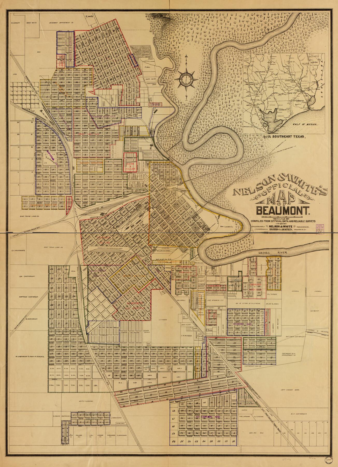
Nelson & White's Official Map of Beaumont
-
Map/Doc
93558
-
Collection
Library of Congress
-
Object Dates
1902 (Creation Date)
-
People and Organizations
Nelson and White (Publisher)
O.M. Simpson (Author)
W.R. Kaufman (Author)
-
Subjects
City
-
Height x Width
54.3 x 39.4 inches
137.9 x 100.1 cm
-
Comments
For more information see here. Prints available from the GLO courtesy of Library of Congress, Geography and Map Division.
Part of: Library of Congress
Roberts County, State of Texas

Print $20.00
Roberts County, State of Texas
1888
Size 21.6 x 16.4 inches
Map/Doc 88990
Map of Texas With Parts of the Adjoining States

Print $20.00
Map of Texas With Parts of the Adjoining States
1837
Size 29.9 x 25.2 inches
Map/Doc 88998
![88994, San Saba Co[unty], Library of Congress](https://historictexasmaps.com/wmedia_w700/maps/88994-1.tif.jpg)

Aeroplane view of business district Amarillo, Texas

Print $20.00
Aeroplane view of business district Amarillo, Texas
1912
Size 18.9 x 21.4 inches
Map/Doc 93467
Map of Wilbarger County, Texas

Print $20.00
Map of Wilbarger County, Texas
1887
Size 11.8 x 8.7 inches
Map/Doc 93587
Map showing the distribution of the slave population of the southern states of the United States. Compiled from the census of 1860

Print $20.00
Map showing the distribution of the slave population of the southern states of the United States. Compiled from the census of 1860
1861
Size 27.8 x 34.8 inches
Map/Doc 95749
Map of Eastland Co[unty]
![88929, Map of Eastland Co[unty], Library of Congress](https://historictexasmaps.com/wmedia_w700/maps/88929.tif.jpg)
Print $20.00
Map of Eastland Co[unty]
1896
Size 45.0 x 42.8 inches
Map/Doc 88929
Carta General de la República Mexicana formada por Antonio García y Cubas

Print $40.00
Carta General de la República Mexicana formada por Antonio García y Cubas
1863
Size 48.7 x 57.1 inches
Map/Doc 95307
Map of Kaufman and Rockwall Counties, Texas

Print $20.00
Map of Kaufman and Rockwall Counties, Texas
1878
Size 23.4 x 17.3 inches
Map/Doc 88963

Sketch of Texas with the boundaries of Mexican States as shown on General Austin's map of Texas

Print $20.00
Sketch of Texas with the boundaries of Mexican States as shown on General Austin's map of Texas
1839
Size 20.9 x 16.1 inches
Map/Doc 93574
You may also like
Crockett County Sketch File 75

Print $20.00
- Digital $50.00
Crockett County Sketch File 75
Size 26.3 x 28.8 inches
Map/Doc 11234
Flight Mission No. DQN-4K, Frame 2, Calhoun County

Print $20.00
- Digital $50.00
Flight Mission No. DQN-4K, Frame 2, Calhoun County
1953
Size 18.6 x 22.2 inches
Map/Doc 84367
Nueces County Navigation District Number One, Submerged Lands Maintained for Navigational Purposes Persuant to Sub-Section G of Section 61.117 Texas Water Code

Print $20.00
- Digital $50.00
Nueces County Navigation District Number One, Submerged Lands Maintained for Navigational Purposes Persuant to Sub-Section G of Section 61.117 Texas Water Code
1975
Size 23.3 x 29.9 inches
Map/Doc 61806
General Highway Map, Dawson County, Texas

Print $20.00
General Highway Map, Dawson County, Texas
1940
Size 18.5 x 25.2 inches
Map/Doc 79071
Harris County State Real Property Sketch 4

Print $20.00
- Digital $50.00
Harris County State Real Property Sketch 4
2004
Size 24.4 x 36.0 inches
Map/Doc 82445
Orange County Sketch File 11a

Print $4.00
- Digital $50.00
Orange County Sketch File 11a
1884
Size 6.1 x 6.1 inches
Map/Doc 33322
Sutton County Rolled Sketch 46

Print $20.00
- Digital $50.00
Sutton County Rolled Sketch 46
1929
Size 19.4 x 15.6 inches
Map/Doc 7887
Located Line of the Panhandle & Gulf Ry. through State Lands, Public School and University, in Reagan County, Texas, Right of Way 200 feet wide

Print $40.00
- Digital $50.00
Located Line of the Panhandle & Gulf Ry. through State Lands, Public School and University, in Reagan County, Texas, Right of Way 200 feet wide
1904
Size 13.4 x 90.8 inches
Map/Doc 64063
Kaufman County Sketch File 7

Print $5.00
- Digital $50.00
Kaufman County Sketch File 7
1847
Size 8.3 x 10.1 inches
Map/Doc 28636
Hardin County Sketch File 8

Print $8.00
- Digital $50.00
Hardin County Sketch File 8
1870
Size 12.6 x 8.1 inches
Map/Doc 25102
DeWitt County Sketch File 11

Print $20.00
- Digital $50.00
DeWitt County Sketch File 11
1851
Size 24.5 x 35.2 inches
Map/Doc 11314
Lee County Working Sketch 17

Print $20.00
- Digital $50.00
Lee County Working Sketch 17
1988
Size 31.8 x 32.2 inches
Map/Doc 70396