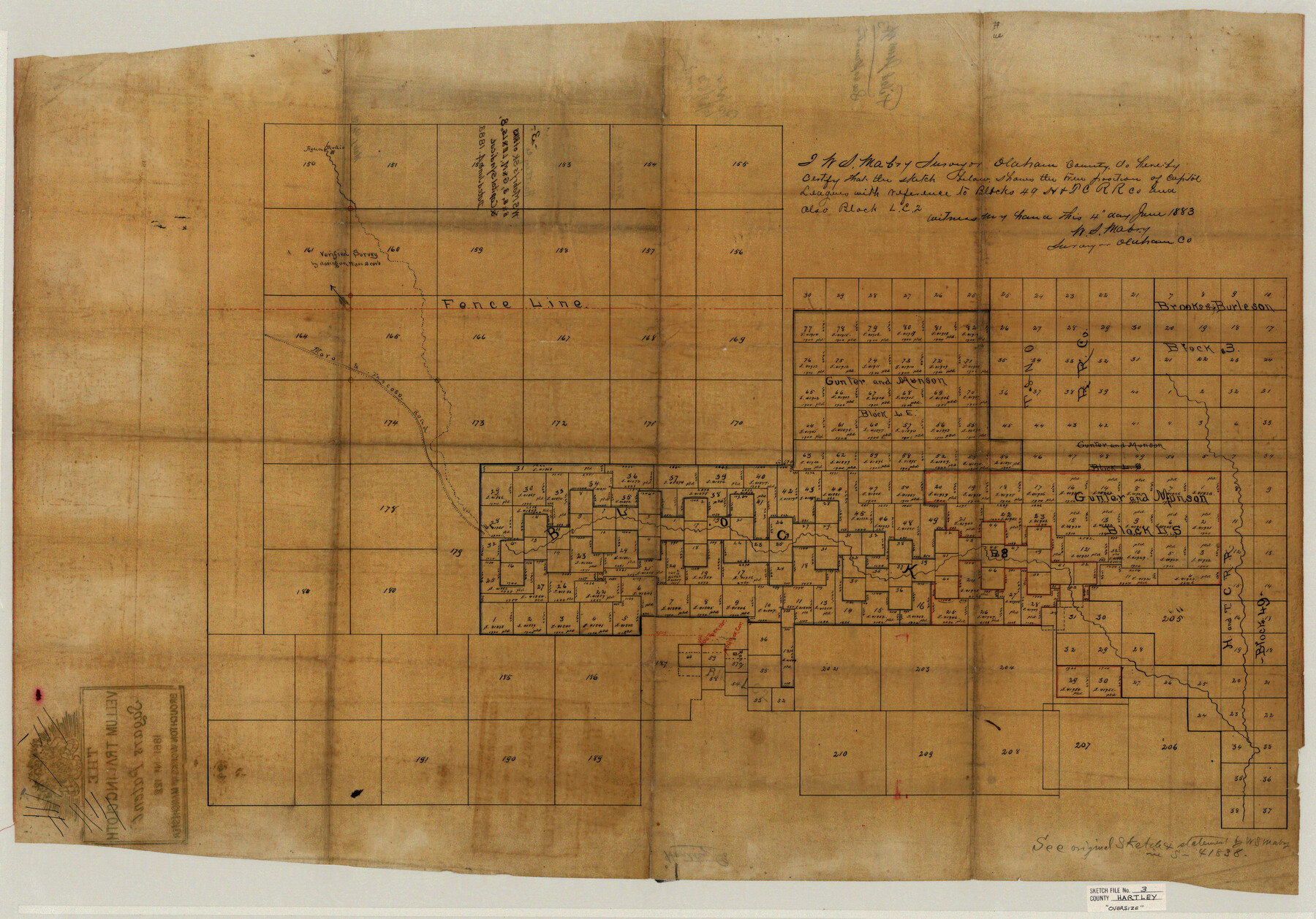
Hartley County Sketch File 3
W.S. Mabry's sk. of Blks. B&B, 3, G&M, LE & LS, 8, & Capitol Syndicat [sp.]
-
Map/Doc
10489
-
Collection
General Map Collection
-
Object Dates
1883/6/4 (Creation Date)
-
People and Organizations
W.S. Mabry (Surveyor/Engineer)
-
Counties
Hartley
-
Subjects
Surveying Sketch File
-
Height x Width
26.8 x 38.4 inches
68.1 x 97.5 cm
-
Medium
paper, manuscript
-
Features
Agua Medio
Moro & Tascoso Road
Part of: General Map Collection
Reeves County Rolled Sketch 32

Print $634.00
- Digital $50.00
Reeves County Rolled Sketch 32
1960
Size 10.2 x 15.4 inches
Map/Doc 48849
Red River County Working Sketch 57

Print $20.00
- Digital $50.00
Red River County Working Sketch 57
1972
Size 31.5 x 28.7 inches
Map/Doc 72040
Castro County Sketch File 4d

Print $4.00
- Digital $50.00
Castro County Sketch File 4d
Size 13.6 x 8.8 inches
Map/Doc 17471
Tyler County Working Sketch 8

Print $20.00
- Digital $50.00
Tyler County Working Sketch 8
1937
Size 31.0 x 34.9 inches
Map/Doc 69478
Flight Mission No. DCL-5C, Frame 66, Kenedy County

Print $20.00
- Digital $50.00
Flight Mission No. DCL-5C, Frame 66, Kenedy County
1943
Size 18.4 x 22.3 inches
Map/Doc 85849
Flight Mission No. CLL-1N, Frame 36, Willacy County

Print $20.00
- Digital $50.00
Flight Mission No. CLL-1N, Frame 36, Willacy County
1954
Size 18.3 x 22.1 inches
Map/Doc 87017
Cameron County Rolled Sketch 31

Print $20.00
- Digital $50.00
Cameron County Rolled Sketch 31
1993
Size 18.4 x 24.3 inches
Map/Doc 5395
Haskell County Rolled Sketch 15A

Print $3.00
- Digital $50.00
Haskell County Rolled Sketch 15A
1991
Size 11.3 x 17.1 inches
Map/Doc 6174
Palo Pinto County Rolled Sketch 2

Print $20.00
- Digital $50.00
Palo Pinto County Rolled Sketch 2
1917
Size 37.5 x 43.8 inches
Map/Doc 9669
Young County Working Sketch 9

Print $20.00
- Digital $50.00
Young County Working Sketch 9
1921
Size 25.9 x 36.6 inches
Map/Doc 62032
Blanco County Rolled Sketch 15

Print $20.00
- Digital $50.00
Blanco County Rolled Sketch 15
Size 12.9 x 13.7 inches
Map/Doc 5151
Kent County Sketch File A

Print $4.00
- Digital $50.00
Kent County Sketch File A
Size 8.2 x 9.0 inches
Map/Doc 28821
You may also like
Orange County Working Sketch 43

Print $20.00
- Digital $50.00
Orange County Working Sketch 43
1980
Size 18.3 x 18.4 inches
Map/Doc 71375
General Highway Map, Jones County, Texas

Print $20.00
General Highway Map, Jones County, Texas
1961
Size 18.2 x 24.5 inches
Map/Doc 79546
Reeves County Rolled Sketch 29

Print $20.00
- Digital $50.00
Reeves County Rolled Sketch 29
1986
Size 21.6 x 27.5 inches
Map/Doc 7498
Greer County Sketch File 4

Print $4.00
- Digital $50.00
Greer County Sketch File 4
1883
Size 8.6 x 5.5 inches
Map/Doc 24519
Subdivision Map of Fisher County School Land situated in Bailey and Cochran Counties, Texas

Print $20.00
- Digital $50.00
Subdivision Map of Fisher County School Land situated in Bailey and Cochran Counties, Texas
1924
Size 17.3 x 21.3 inches
Map/Doc 90111
Delta County Working Sketch Graphic Index

Print $20.00
- Digital $50.00
Delta County Working Sketch Graphic Index
1942
Size 25.3 x 39.2 inches
Map/Doc 76520
Flight Mission No. CGI-4N, Frame 160, Cameron County

Print $20.00
- Digital $50.00
Flight Mission No. CGI-4N, Frame 160, Cameron County
1955
Size 18.5 x 22.3 inches
Map/Doc 84668
Energy Map of Texas

Print $20.00
- Digital $50.00
Energy Map of Texas
2020
Size 36.0 x 36.0 inches
Map/Doc 96436
Current Miscellaneous File 66

Print $34.00
- Digital $50.00
Current Miscellaneous File 66
Size 11.2 x 8.6 inches
Map/Doc 74113
Smithville, Bastrop County, Texas

Print $3.00
- Digital $50.00
Smithville, Bastrop County, Texas
1895
Size 11.0 x 17.2 inches
Map/Doc 531
Glasscock County Sketch File 27

Print $10.00
- Digital $50.00
Glasscock County Sketch File 27
1989
Size 11.3 x 8.8 inches
Map/Doc 24206
A General Map of the Northern British Colonies in America which comprehends the Province of Quebec, the Government of Newfoundland, Nova-Scotia, New England and New York

Print $20.00
- Digital $50.00
A General Map of the Northern British Colonies in America which comprehends the Province of Quebec, the Government of Newfoundland, Nova-Scotia, New England and New York
1776
Size 21.3 x 27.3 inches
Map/Doc 97401