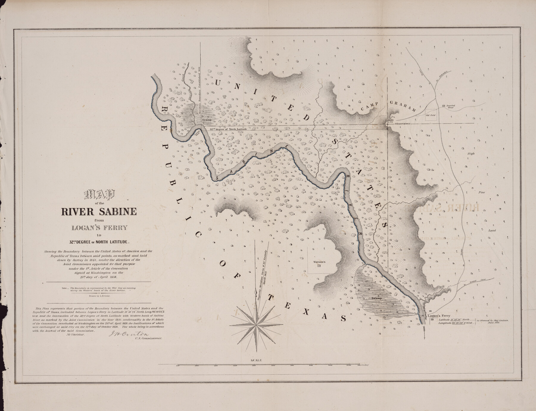
Map of the River Sabine from Logan's Ferry to 32nd Degree of North Latitude
-
Map/Doc
88902
-
Collection
Library of Congress
-
Object Dates
1841 (Creation Date)
-
People and Organizations
A.B. Gray (Draftsman)
-
Subjects
River Surveys Texas Boundaries
-
Height x Width
21.4 x 27.8 inches
54.4 x 70.6 cm
-
Comments
For more information see here. Prints available from the GLO courtesy of Library of Congress, Geography and Map Division.
Part of: Library of Congress
[Map showing T&P Lands in El Paso County]
![88930, [Map showing T&P Lands in El Paso County], Library of Congress](https://historictexasmaps.com/wmedia_w700/maps/88930.tif.jpg)
Print $20.00
[Map showing T&P Lands in El Paso County]
Size 17.5 x 22.3 inches
Map/Doc 88930
Red River County, Texas

Print $20.00
Red River County, Texas
1870
Size 22.4 x 17.3 inches
Map/Doc 88989

[Map showing T&P Lands in El Paso County]
![88932, [Map showing T&P Lands in El Paso County], Library of Congress](https://historictexasmaps.com/wmedia_w700/maps/88932.tif.jpg)
Print $20.00
[Map showing T&P Lands in El Paso County]
Size 22.2 x 17.1 inches
Map/Doc 88932
Honey Grove, Tex., Fannin County, 1886

Print $20.00
Honey Grove, Tex., Fannin County, 1886
1886
Size 18.4 x 23.9 inches
Map/Doc 93479
J. De Cordova's Map of the State of Texas Compiled from the records of the General Land Office of the State

Print $20.00
J. De Cordova's Map of the State of Texas Compiled from the records of the General Land Office of the State
1853
Size 35.0 x 35.0 inches
Map/Doc 88903


Preliminary Chart of the Northwestern Part of the Gulf of Mexico - Unfinished Proof

Print $40.00
Preliminary Chart of the Northwestern Part of the Gulf of Mexico - Unfinished Proof
1861
Size 31.5 x 68.9 inches
Map/Doc 95308
Map showing the Kansas & Gulf Short Line R.R. and the Texas & St. Louis R'y with its branches, extensions and connections.

Print $20.00
Map showing the Kansas & Gulf Short Line R.R. and the Texas & St. Louis R'y with its branches, extensions and connections.
1881
Size 30.3 x 30.9 inches
Map/Doc 93608
Map of Harris County, Texas

Print $20.00
Map of Harris County, Texas
1879
Size 24.8 x 36.0 inches
Map/Doc 88948
General Chart of the Kingdom of New Spain betn. parallels of 16 & 38° N. from materials in Mexico at commencement of year of 1804

Print $20.00
General Chart of the Kingdom of New Spain betn. parallels of 16 & 38° N. from materials in Mexico at commencement of year of 1804
1804
Size 38.4 x 26.5 inches
Map/Doc 95310
You may also like
Crosby County Sketch File 33

Print $20.00
- Digital $50.00
Crosby County Sketch File 33
1954
Size 30.9 x 37.1 inches
Map/Doc 10354
Brazoria County Sketch File 21

Print $4.00
- Digital $50.00
Brazoria County Sketch File 21
Size 8.3 x 7.5 inches
Map/Doc 15016
Zapata County Rolled Sketch 12 1/2

Print $40.00
- Digital $50.00
Zapata County Rolled Sketch 12 1/2
1917
Size 53.1 x 38.8 inches
Map/Doc 10167
Map of Kinney County

Print $20.00
- Digital $50.00
Map of Kinney County
1888
Size 27.5 x 26.1 inches
Map/Doc 3779
Delta County Sketch File 2

Print $4.00
- Digital $50.00
Delta County Sketch File 2
1871
Size 8.4 x 13.2 inches
Map/Doc 20670
Potter County Rolled Sketch 3

Print $20.00
- Digital $50.00
Potter County Rolled Sketch 3
1892
Map/Doc 9758
Val Verde County Working Sketch 15

Print $20.00
- Digital $50.00
Val Verde County Working Sketch 15
1926
Size 35.3 x 25.0 inches
Map/Doc 72150
Dallam County Boundary File 4

Print $80.00
- Digital $50.00
Dallam County Boundary File 4
Size 9.4 x 49.8 inches
Map/Doc 52082
El Paso County Sketch File 31

Print $185.00
- Digital $50.00
El Paso County Sketch File 31
1968
Size 8.9 x 17.7 inches
Map/Doc 22084

La Salle County Working Sketch 15

Print $20.00
- Digital $50.00
La Salle County Working Sketch 15
1935
Size 27.4 x 17.2 inches
Map/Doc 70316
Blanco County Working Sketch 33

Print $40.00
- Digital $50.00
Blanco County Working Sketch 33
1978
Size 41.0 x 57.5 inches
Map/Doc 67393