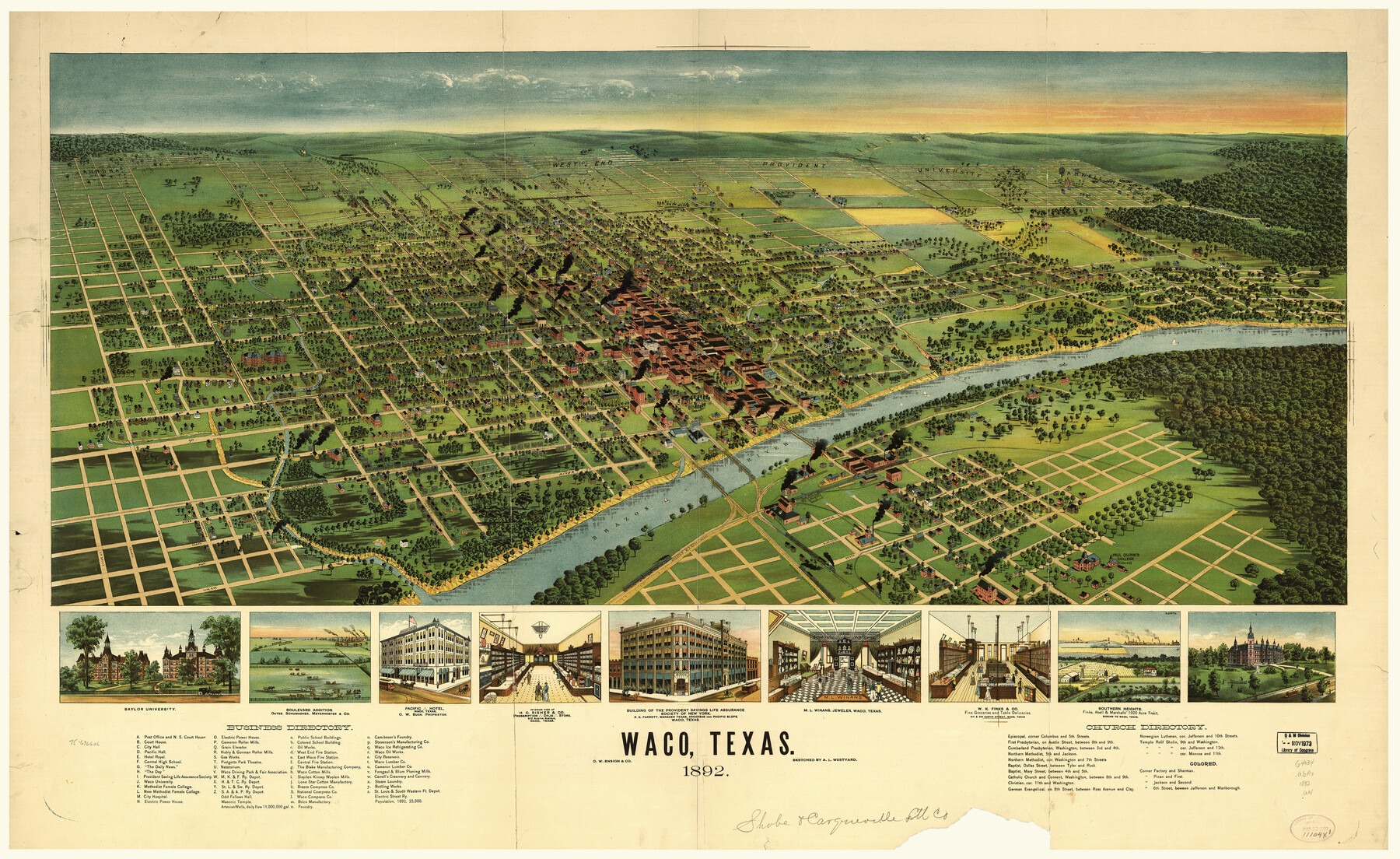
Waco, Texas 1892
-
Map/Doc
93469
-
Collection
Library of Congress
-
Object Dates
1892 (Creation Date)
-
People and Organizations
D. W. Ensign and Co. (Publisher)
A.L. Westyard (Draftsman)
-
Counties
McLennan
-
Subjects
Bird's Eye View City Pictorial
-
Height x Width
14.5 x 23.9 inches
36.8 x 60.7 cm
-
Comments
Bird's Eye View map. For more information see here. Prints available from the GLO courtesy of Library of Congress, Geography and Map Division.
Part of: Library of Congress
![88994, San Saba Co[unty], Library of Congress](https://historictexasmaps.com/wmedia_w700/maps/88994-1.tif.jpg)
Preliminary Chart of the Northwestern Part of the Gulf of Mexico - Unfinished Proof

Print $40.00
Preliminary Chart of the Northwestern Part of the Gulf of Mexico - Unfinished Proof
1861
Size 31.5 x 68.9 inches
Map/Doc 95308

Map of Hill County, Texas

Print $20.00
Map of Hill County, Texas
1886
Size 22.4 x 28.3 inches
Map/Doc 88955


J. De Cordova's Map of the State of Texas Compiled from the records of the General Land Office of the State

Print $20.00
J. De Cordova's Map of the State of Texas Compiled from the records of the General Land Office of the State
1853
Size 35.0 x 35.0 inches
Map/Doc 88903


Map of Matagorda County, Texas

Print $20.00
Map of Matagorda County, Texas
1879
Size 30.7 x 27.4 inches
Map/Doc 88978
You may also like
Traced from Genl. Arista's map captured by the American Army under Genl. Taylor at Resaca de la Palma 9th May '46 and presented to James K. Polk, President U. States

Print $20.00
- Digital $50.00
Traced from Genl. Arista's map captured by the American Army under Genl. Taylor at Resaca de la Palma 9th May '46 and presented to James K. Polk, President U. States
1846
Size 18.1 x 27.3 inches
Map/Doc 73062
Controlled Mosaic by Jack Amman Photogrammetric Engineers, Inc - Sheet 21

Print $20.00
- Digital $50.00
Controlled Mosaic by Jack Amman Photogrammetric Engineers, Inc - Sheet 21
1954
Size 20.0 x 24.0 inches
Map/Doc 83470
Flight Mission No. DAH-9M, Frame 161, Orange County

Print $20.00
- Digital $50.00
Flight Mission No. DAH-9M, Frame 161, Orange County
1953
Size 18.6 x 22.4 inches
Map/Doc 86860
Williamson County Rolled Sketch 8

Print $20.00
- Digital $50.00
Williamson County Rolled Sketch 8
Size 15.1 x 18.0 inches
Map/Doc 8265
El Paso County Rolled Sketch 52

Print $20.00
- Digital $50.00
El Paso County Rolled Sketch 52
1929
Size 18.5 x 24.5 inches
Map/Doc 5847
[M. B. & B. Blks. A, B & C near Coyote Lake]
![90249, [M. B. & B. Blks. A, B & C near Coyote Lake], Twichell Survey Records](https://historictexasmaps.com/wmedia_w700/maps/90249-1.tif.jpg)
Print $20.00
- Digital $50.00
[M. B. & B. Blks. A, B & C near Coyote Lake]
Size 15.4 x 23.3 inches
Map/Doc 90249
San Patricio County Rolled Sketch 46B

Print $3.00
- Digital $50.00
San Patricio County Rolled Sketch 46B
1983
Size 12.5 x 10.0 inches
Map/Doc 8373
Stonewall County Sketch File 24

Print $6.00
- Digital $50.00
Stonewall County Sketch File 24
1951
Size 24.8 x 35.2 inches
Map/Doc 12369
[Old Surveys, Robertson Colony in Milam County]
![78268, [Old Surveys, Robertson Colony in Milam County], General Map Collection](https://historictexasmaps.com/wmedia_w700/maps/78268.tif.jpg)
Print $20.00
- Digital $50.00
[Old Surveys, Robertson Colony in Milam County]
Size 12.2 x 15.6 inches
Map/Doc 78268
Travis County Boundary File 6

Print $109.00
- Digital $50.00
Travis County Boundary File 6
Size 14.6 x 9.1 inches
Map/Doc 59433
Jefferson County Aerial Photograph Index Sheet 5

Print $20.00
- Digital $50.00
Jefferson County Aerial Photograph Index Sheet 5
1953
Size 23.3 x 16.9 inches
Map/Doc 83709
Flight Mission No. BRE-1P, Frame 73, Nueces County

Print $20.00
- Digital $50.00
Flight Mission No. BRE-1P, Frame 73, Nueces County
1956
Size 18.5 x 22.4 inches
Map/Doc 86655