Collin County State Real Property Sketch 1
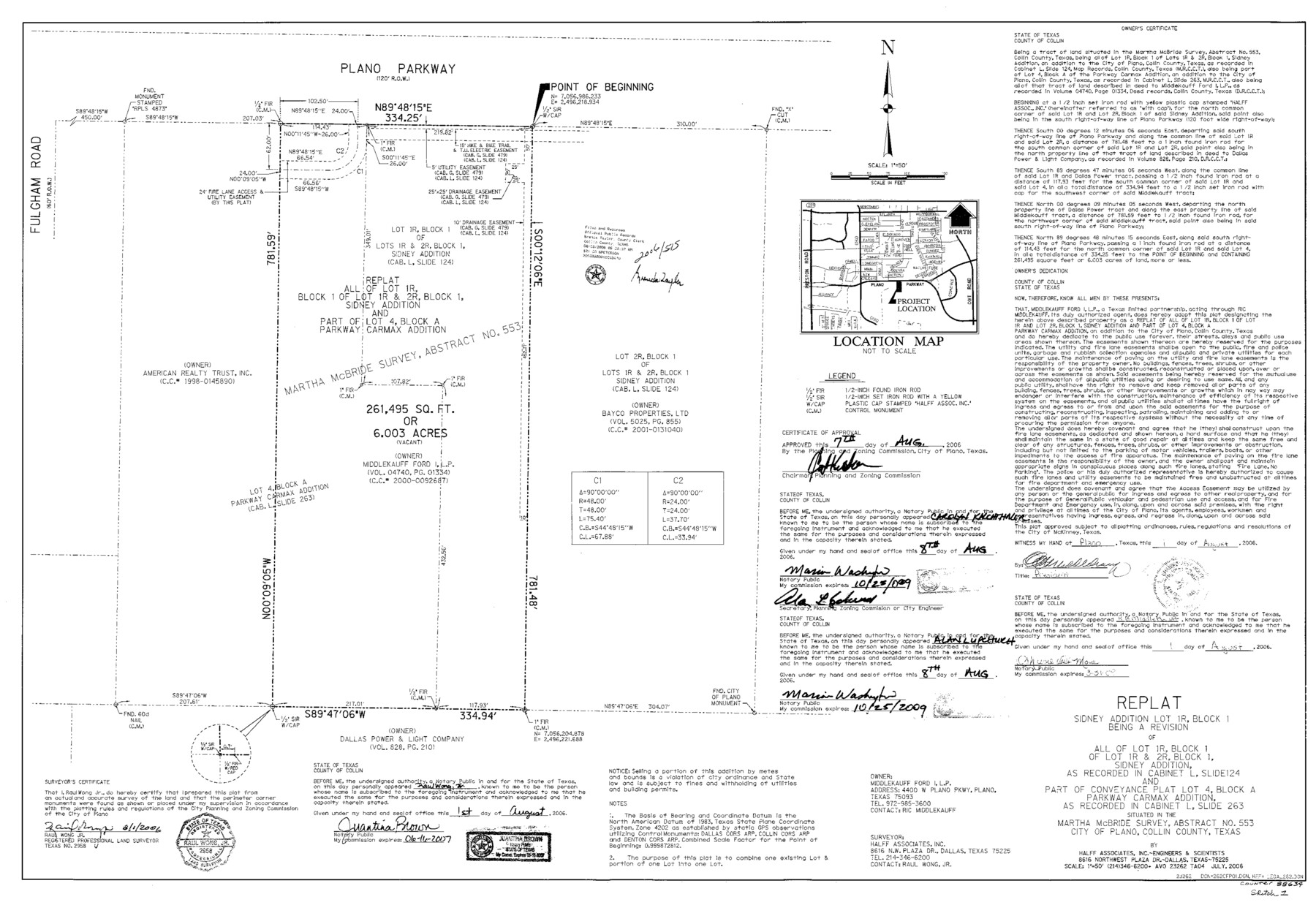
A Replat of the Sidney Addition Lot 1R, Block 1, Being a Revision of All of Lot 1R, Block 1 of Lot 1R & 2R, Block 1, Sidney Addition and Part of Conveyance Plat Lot 4, Block A, Parkway Carman Addition, Situated in Martha McBide Survey, A - 553
-
Map/Doc
88634
-
Collection
General Map Collection
-
Object Dates
2006 (Creation Date)
-
People and Organizations
Halff Associates, Inc. (Publisher)
Halff Associates, Inc. (Printer)
Raul Wong Jr (Surveyor/Engineer)
-
Counties
Collin
-
Subjects
State Real Property
-
Height x Width
24.1 x 35.1 inches
61.2 x 89.2 cm
-
Comments
Surveys located about 16 miles South 34 degrees West of McKinney, Texas.
Part of: General Map Collection
Hays County Sketch File 36

Print $4.00
- Digital $50.00
Hays County Sketch File 36
Size 11.0 x 8.5 inches
Map/Doc 96639
Tyler County Working Sketch 1

Print $20.00
- Digital $50.00
Tyler County Working Sketch 1
1911
Size 19.0 x 15.0 inches
Map/Doc 69471
Sherman County

Print $20.00
- Digital $50.00
Sherman County
1932
Size 39.6 x 36.4 inches
Map/Doc 77422
Armstrong County

Print $20.00
- Digital $50.00
Armstrong County
1933
Size 39.3 x 39.4 inches
Map/Doc 77203
Navarro County Working Sketch 1b

Print $20.00
- Digital $50.00
Navarro County Working Sketch 1b
Size 32.5 x 44.6 inches
Map/Doc 71230
Hays County Rolled Sketch 27

Print $20.00
- Digital $50.00
Hays County Rolled Sketch 27
1948
Size 34.0 x 43.0 inches
Map/Doc 9149
Childress County Rolled Sketch 5A

Print $20.00
- Digital $50.00
Childress County Rolled Sketch 5A
Size 32.9 x 21.9 inches
Map/Doc 5440
Flight Mission No. CGI-3N, Frame 75, Cameron County

Print $20.00
- Digital $50.00
Flight Mission No. CGI-3N, Frame 75, Cameron County
1954
Size 18.6 x 22.2 inches
Map/Doc 84569
Shores of Laguna Madre, Texas from Triangulation Station Peat ID to Crane Islands

Print $40.00
- Digital $50.00
Shores of Laguna Madre, Texas from Triangulation Station Peat ID to Crane Islands
1882
Size 33.7 x 54.6 inches
Map/Doc 73481

DeWitt County Sketch File 4

Print $4.00
- Digital $50.00
DeWitt County Sketch File 4
1872
Size 8.3 x 13.1 inches
Map/Doc 20801
Layout of the porciones as described in the Visita General of Laredo, 1767

Layout of the porciones as described in the Visita General of Laredo, 1767
2009
Size 11.0 x 8.5 inches
Map/Doc 94042
You may also like
Clarkson's City Map of Port Aransas

Print $20.00
- Digital $50.00
Clarkson's City Map of Port Aransas
Size 18.5 x 26.7 inches
Map/Doc 3038
Angelina County

Print $40.00
- Digital $50.00
Angelina County
1899
Size 38.9 x 49.9 inches
Map/Doc 4873
Stonewall County Working Sketch 17

Print $20.00
- Digital $50.00
Stonewall County Working Sketch 17
1954
Size 31.5 x 24.7 inches
Map/Doc 62324
McMullen County Sketch File 47

Print $20.00
- Digital $50.00
McMullen County Sketch File 47
1989
Size 24.6 x 21.5 inches
Map/Doc 12066
Howard County Sketch File 12

Print $20.00
- Digital $50.00
Howard County Sketch File 12
1939
Size 18.2 x 15.7 inches
Map/Doc 11799
McCulloch County Sketch File 1

Print $4.00
- Digital $50.00
McCulloch County Sketch File 1
1854
Size 8.7 x 6.8 inches
Map/Doc 31165

Subdivision of Midland County School Land, Hockley and Cochran Counties, Texas

Print $20.00
- Digital $50.00
Subdivision of Midland County School Land, Hockley and Cochran Counties, Texas
Size 30.5 x 23.3 inches
Map/Doc 92517
Section P Tech Memorial Park, Inc.

Print $20.00
- Digital $50.00
Section P Tech Memorial Park, Inc.
1953
Size 21.1 x 32.3 inches
Map/Doc 92353
Sulphur River, Terry Lake Sheet

Print $20.00
- Digital $50.00
Sulphur River, Terry Lake Sheet
1919
Size 28.6 x 30.9 inches
Map/Doc 65161
Flight Mission No. CRC-2R, Frame 184, Chambers County

Print $20.00
- Digital $50.00
Flight Mission No. CRC-2R, Frame 184, Chambers County
1956
Size 18.6 x 22.2 inches
Map/Doc 84762
Sterling County Sketch File 3

Print $20.00
- Digital $50.00
Sterling County Sketch File 3
Size 14.5 x 34.8 inches
Map/Doc 12355