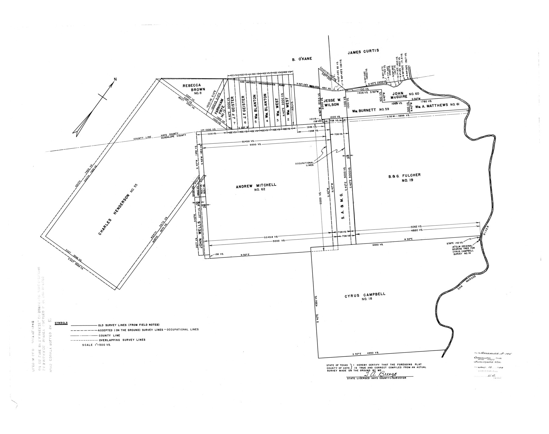
Hays County Rolled Sketch 27
[Sketch of area around Hays-Guadalupe County line]
-
Map/Doc
9149
-
Collection
General Map Collection
-
Object Dates
1948/6/25 (Creation Date)
1948/7/10 (File Date)
-
People and Organizations
T.A. Breeze (Surveyor/Engineer)
-
Counties
Hays Guadalupe
-
Subjects
Surveying Rolled Sketch
-
Height x Width
34.0 x 43.0 inches
86.4 x 109.2 cm
-
Scale
1" = 500 varas
Part of: General Map Collection
Flight Mission No. DQO-2K, Frame 88, Galveston County

Print $20.00
- Digital $50.00
Flight Mission No. DQO-2K, Frame 88, Galveston County
1952
Size 18.8 x 22.5 inches
Map/Doc 85015
Sabine River, Merrill Lake Sheet

Print $20.00
- Digital $50.00
Sabine River, Merrill Lake Sheet
1933
Size 26.4 x 43.6 inches
Map/Doc 65137
Nueces County Rolled Sketch 62

Print $20.00
- Digital $50.00
Nueces County Rolled Sketch 62
1977
Size 25.0 x 33.3 inches
Map/Doc 6908
Coke County Rolled Sketch 19A

Print $20.00
- Digital $50.00
Coke County Rolled Sketch 19A
1954
Size 19.9 x 24.8 inches
Map/Doc 5520
Map of Jack County

Print $20.00
- Digital $50.00
Map of Jack County
1868
Size 23.8 x 19.8 inches
Map/Doc 3701
Val Verde County Working Sketch 29

Print $20.00
- Digital $50.00
Val Verde County Working Sketch 29
1937
Size 20.2 x 41.6 inches
Map/Doc 72164
Stephens County Sketch File 22

Print $40.00
- Digital $50.00
Stephens County Sketch File 22
1919
Size 22.1 x 28.8 inches
Map/Doc 12352
Reeves County Working Sketch 19

Print $20.00
- Digital $50.00
Reeves County Working Sketch 19
1962
Size 42.3 x 42.7 inches
Map/Doc 63462
A General Map of the Middle British Colonies, in America. containing Virginia, Maryland, the Delaware Counties, Pennsylvania and New Jersey. With the addition of New York and of the Greatest Part of New England

Print $20.00
- Digital $50.00
A General Map of the Middle British Colonies, in America. containing Virginia, Maryland, the Delaware Counties, Pennsylvania and New Jersey. With the addition of New York and of the Greatest Part of New England
1776
Size 21.6 x 27.2 inches
Map/Doc 97402
Castro County Rolled Sketch 8

Print $20.00
- Digital $50.00
Castro County Rolled Sketch 8
Size 34.1 x 28.8 inches
Map/Doc 5418
Stephens County Sketch File 14

Print $6.00
- Digital $50.00
Stephens County Sketch File 14
Size 8.2 x 5.9 inches
Map/Doc 37065
Lampasas County Rolled Sketch 6

Print $20.00
- Digital $50.00
Lampasas County Rolled Sketch 6
2014
Size 29.1 x 21.9 inches
Map/Doc 93775
You may also like
Harris County Rolled Sketch 88

Print $20.00
- Digital $50.00
Harris County Rolled Sketch 88
1937
Size 34.8 x 22.8 inches
Map/Doc 6127
Township No. 4 South Range No. 16 West of the Indian Meridian

Print $20.00
- Digital $50.00
Township No. 4 South Range No. 16 West of the Indian Meridian
1875
Size 19.4 x 24.4 inches
Map/Doc 75165
Gillespie County Working Sketch 7

Print $40.00
- Digital $50.00
Gillespie County Working Sketch 7
1984
Size 57.5 x 43.2 inches
Map/Doc 63170
Map of Kerr County

Print $20.00
- Digital $50.00
Map of Kerr County
1864
Size 14.8 x 17.9 inches
Map/Doc 3760
Brazoria County Sketch File 15

Print $4.00
- Digital $50.00
Brazoria County Sketch File 15
1892
Size 12.8 x 8.4 inches
Map/Doc 14977
Pecos County Sketch File 28

Print $20.00
- Digital $50.00
Pecos County Sketch File 28
1927
Size 23.4 x 21.6 inches
Map/Doc 12168
Navasota River, Grayson Crossing Sheet

Print $20.00
- Digital $50.00
Navasota River, Grayson Crossing Sheet
1937
Size 42.8 x 21.1 inches
Map/Doc 65071
Starr County Working Sketch 13

Print $20.00
- Digital $50.00
Starr County Working Sketch 13
1951
Size 19.3 x 28.8 inches
Map/Doc 63929
North Part Brewster Co.

Print $40.00
- Digital $50.00
North Part Brewster Co.
1914
Size 40.1 x 48.6 inches
Map/Doc 66731
Map of the Pitchfork Ranch

Print $20.00
- Digital $50.00
Map of the Pitchfork Ranch
1915
Size 39.9 x 35.9 inches
Map/Doc 75826
Falls County Sketch File 10

Print $14.00
- Digital $50.00
Falls County Sketch File 10
Size 12.9 x 8.4 inches
Map/Doc 22345
Gaines County Rolled Sketch 11

Print $20.00
- Digital $50.00
Gaines County Rolled Sketch 11
1939
Size 22.4 x 32.9 inches
Map/Doc 5931