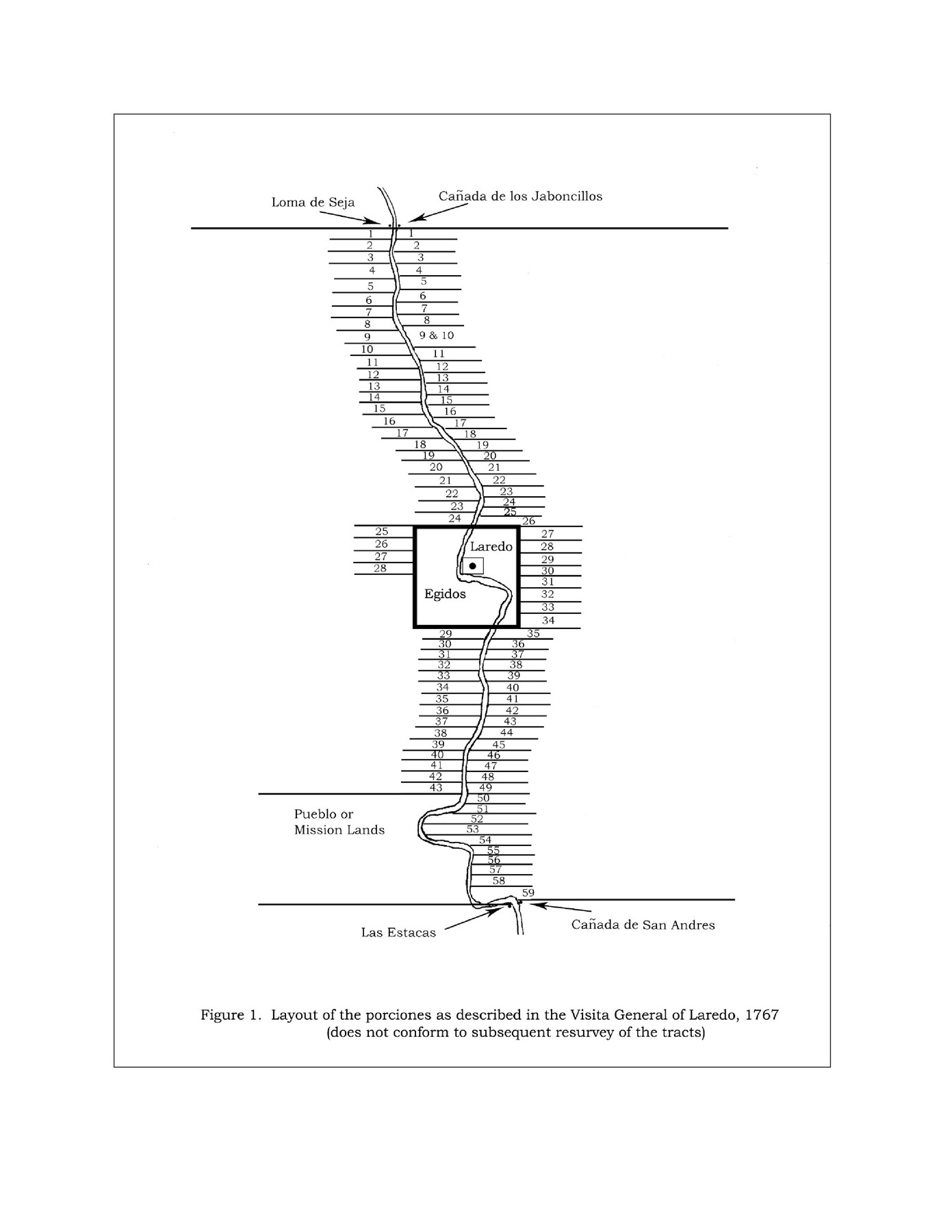
Layout of the porciones as described in the Visita General of Laredo, 1767
-
Map/Doc
94042
-
Collection
General Map Collection
-
Object Dates
2009 (Creation Date)
-
People and Organizations
Texas General Land Office (Publisher)
Galen D. Greaser (Author)
Jeff Perkins (Author)
Kevin Klaus (Author)
-
Subjects
Mexican Texas Spanish Texas
-
Height x Width
11.0 x 8.5 inches
27.9 x 21.6 cm
-
Medium
digital image
-
Comments
Figure 1 from the "New Guide to Spanish and Mexican Land Grants in South Texas", GLO Doc# 83388 (p. 29).
See 94040, 94041, 94043, 94044, 94045, and 94046 for other figures from this guide.
Related maps
New Guide to Spanish and Mexican Land Grants in South Texas

Price $15.00
New Guide to Spanish and Mexican Land Grants in South Texas
2009
Size 11.0 x 8.5 inches
Map/Doc 83388
Land grants from the state of Tamaulipas in the trans-Nueces

Land grants from the state of Tamaulipas in the trans-Nueces
2009
Size 11.0 x 8.5 inches
Map/Doc 94040
Layout of the porciones as described in the Visita General of Camargo, 1767

Layout of the porciones as described in the Visita General of Camargo, 1767
2009
Size 11.0 x 8.5 inches
Map/Doc 94041
Layout of the porciones as described in the Visita General of Mier, 1767

Layout of the porciones as described in the Visita General of Mier, 1767
2009
Size 11.0 x 8.5 inches
Map/Doc 94043
Layout of the porciones as described in the Visita General of Revilla (Guerrero), 1767, along with six tracts distributed by Gov. Lasaga in 1784 and three others (39-41) assigned at a later date

Layout of the porciones as described in the Visita General of Revilla (Guerrero), 1767, along with six tracts distributed by Gov. Lasaga in 1784 and three others (39-41) assigned at a later date
2009
Size 11.0 x 8.5 inches
Map/Doc 94044
Layout of the porciones as described in the Visita General of Reynosa, 1767

Layout of the porciones as described in the Visita General of Reynosa, 1767
2009
Size 11.0 x 8.5 inches
Map/Doc 94045
Spanish land grants (other than porciones) in the trans-Nueces

Spanish land grants (other than porciones) in the trans-Nueces
2009
Size 11.0 x 8.5 inches
Map/Doc 94046
Part of: General Map Collection
Cottle County Working Sketch 22

Print $40.00
- Digital $50.00
Cottle County Working Sketch 22
1982
Size 44.0 x 75.0 inches
Map/Doc 68332
Flight Mission No. BQY-4M, Frame 53, Harris County

Print $20.00
- Digital $50.00
Flight Mission No. BQY-4M, Frame 53, Harris County
1953
Size 18.6 x 22.3 inches
Map/Doc 85262
Flight Mission No. DQN-3K, Frame 5, Calhoun County

Print $20.00
- Digital $50.00
Flight Mission No. DQN-3K, Frame 5, Calhoun County
1953
Size 18.4 x 22.1 inches
Map/Doc 84337
Flight Mission No. DQN-1K, Frame 71, Calhoun County

Print $20.00
- Digital $50.00
Flight Mission No. DQN-1K, Frame 71, Calhoun County
1953
Size 18.9 x 22.5 inches
Map/Doc 84158
Map of Fort Bend Co.

Print $20.00
- Digital $50.00
Map of Fort Bend Co.
1898
Size 45.1 x 41.1 inches
Map/Doc 75965
Zapata County Sketch File 2

Print $20.00
- Digital $50.00
Zapata County Sketch File 2
1875
Size 24.3 x 32.8 inches
Map/Doc 12718
Williamson County

Print $40.00
- Digital $50.00
Williamson County
1946
Size 38.7 x 56.8 inches
Map/Doc 95676
Potter County Working Sketch 1

Print $20.00
- Digital $50.00
Potter County Working Sketch 1
Size 16.3 x 17.2 inches
Map/Doc 71661
Presidio County Rolled Sketch 147

Print $20.00
- Digital $50.00
Presidio County Rolled Sketch 147
2019
Size 35.2 x 24.1 inches
Map/Doc 95703
Sutton County Sketch File 23

Print $30.00
- Digital $50.00
Sutton County Sketch File 23
1918
Size 14.2 x 8.5 inches
Map/Doc 37461
Williamson County Rolled Sketch 5

Print $20.00
- Digital $50.00
Williamson County Rolled Sketch 5
1940
Size 23.7 x 34.5 inches
Map/Doc 8263
Wichita County Sketch File 16a

Print $4.00
- Digital $50.00
Wichita County Sketch File 16a
Size 14.2 x 8.7 inches
Map/Doc 40097
You may also like
Flight Mission No. DIX-8P, Frame 74, Aransas County

Print $20.00
- Digital $50.00
Flight Mission No. DIX-8P, Frame 74, Aransas County
1956
Size 18.7 x 22.5 inches
Map/Doc 83905
Current Miscellaneous File 51

Print $6.00
- Digital $50.00
Current Miscellaneous File 51
Size 11.6 x 9.2 inches
Map/Doc 74029
Archer County Sketch File 8a

Print $8.00
- Digital $50.00
Archer County Sketch File 8a
Size 8.8 x 7.1 inches
Map/Doc 13639
Victoria County Working Sketch 11

Print $20.00
- Digital $50.00
Victoria County Working Sketch 11
2004
Size 34.7 x 36.0 inches
Map/Doc 83591
Val Verde County Rolled Sketch 27

Print $20.00
- Digital $50.00
Val Verde County Rolled Sketch 27
Size 26.0 x 37.9 inches
Map/Doc 8109
[Surveys in Austin's Colony at Matagorda Bay and along the Trespalacios and Colorado Rivers]
![147, [Surveys in Austin's Colony at Matagorda Bay and along the Trespalacios and Colorado Rivers], General Map Collection](https://historictexasmaps.com/wmedia_w700/maps/147.tif.jpg)
Print $20.00
- Digital $50.00
[Surveys in Austin's Colony at Matagorda Bay and along the Trespalacios and Colorado Rivers]
1821
Size 31.6 x 20.5 inches
Map/Doc 147
Henderson County

Print $20.00
- Digital $50.00
Henderson County
1856
Size 17.9 x 29.2 inches
Map/Doc 3664
Smith County Boundary File 80

Print $8.00
- Digital $50.00
Smith County Boundary File 80
Size 9.0 x 6.2 inches
Map/Doc 58797
Texas compiled from the latest and best authorities

Print $20.00
- Digital $50.00
Texas compiled from the latest and best authorities
1842
Size 11.8 x 14.0 inches
Map/Doc 93864
Oldham County Working Sketch 11

Print $20.00
- Digital $50.00
Oldham County Working Sketch 11
2014
Size 26.6 x 32.7 inches
Map/Doc 93686
Oldham County Sketch File 17

Print $10.00
- Digital $50.00
Oldham County Sketch File 17
1904
Size 7.7 x 6.4 inches
Map/Doc 33267
[The S.K. Ry. of Texas, State Line to Pecos, Reeves Co., Texas]
![64162, [The S.K. Ry. of Texas, State Line to Pecos, Reeves Co., Texas], General Map Collection](https://historictexasmaps.com/wmedia_w700/maps/64162.tif.jpg)
Print $40.00
- Digital $50.00
[The S.K. Ry. of Texas, State Line to Pecos, Reeves Co., Texas]
1910
Size 19.8 x 120.7 inches
Map/Doc 64162