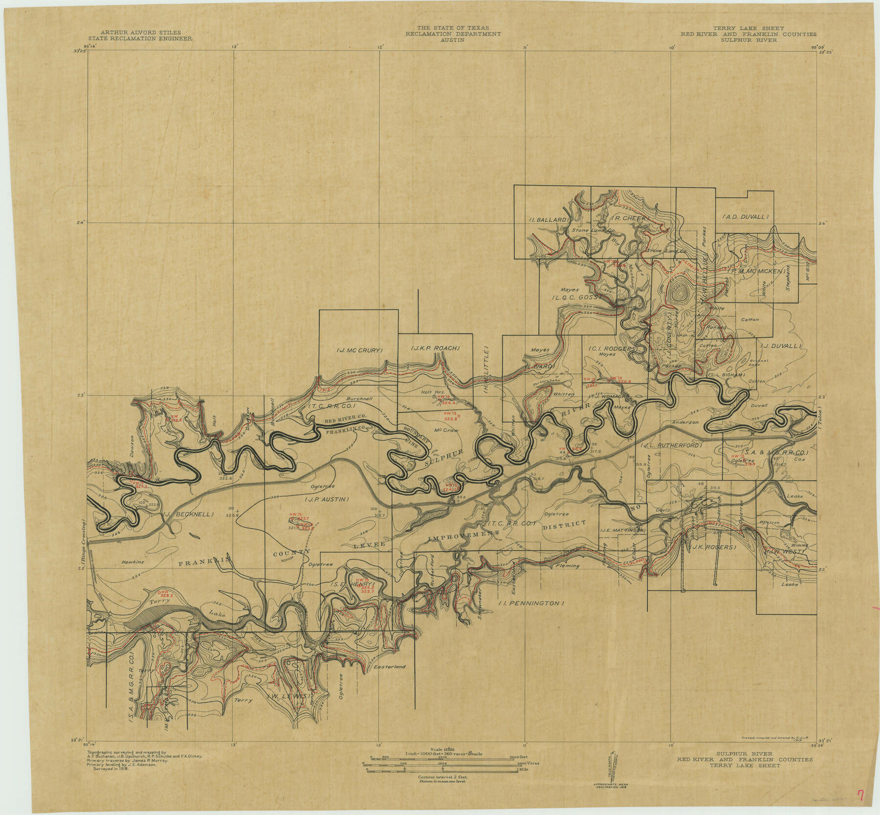
Sulphur River, Terry Lake Sheet
-
Map/Doc
65161
-
Collection
General Map Collection
-
Object Dates
1919 (Creation Date)
-
People and Organizations
Texas State Reclamation Department (Publisher)
Ernest J. von Rosenberg (Compiler)
Ernest J. von Rosenberg (Draftsman)
J.B. Upchurch (Surveyor/Engineer)
F.A. Dickey (Surveyor/Engineer)
A.F. Buchanan (Surveyor/Engineer)
R.P. Schulke (Surveyor/Engineer)
-
Counties
Red River Franklin
-
Subjects
River Surveys Topographic
-
Height x Width
28.6 x 30.9 inches
72.6 x 78.5 cm
-
Comments
Terry Lake Sheet located between the Ringo Crossing Sheet and the Talco Sheet.
Part of: General Map Collection
Ector County Working Sketch 21

Print $40.00
- Digital $50.00
Ector County Working Sketch 21
Size 41.3 x 117.7 inches
Map/Doc 68864
Bowie County Sketch File 7b

Print $10.00
- Digital $50.00
Bowie County Sketch File 7b
1927
Size 10.7 x 8.6 inches
Map/Doc 14859
Flight Mission No. CRC-5R, Frame 37, Chambers County

Print $20.00
- Digital $50.00
Flight Mission No. CRC-5R, Frame 37, Chambers County
1956
Size 18.6 x 22.4 inches
Map/Doc 84956
Nueces County Rolled Sketch 86

Print $167.00
Nueces County Rolled Sketch 86
1983
Size 18.2 x 24.7 inches
Map/Doc 6978
Harris County Rolled Sketch 82

Print $40.00
- Digital $50.00
Harris County Rolled Sketch 82
1956
Size 50.5 x 36.4 inches
Map/Doc 9138
Burleson County Working Sketch 4

Print $20.00
- Digital $50.00
Burleson County Working Sketch 4
1979
Size 33.3 x 35.6 inches
Map/Doc 67723
United States including territories and insular possessions showing the extent of public surveys, national parks, national forests, indian reservations, national wildlife refuges, and reclamation projects

Print $40.00
- Digital $50.00
United States including territories and insular possessions showing the extent of public surveys, national parks, national forests, indian reservations, national wildlife refuges, and reclamation projects
1953
Size 64.3 x 44.5 inches
Map/Doc 65796
San Saba County Boundary File 77

Print $32.00
- Digital $50.00
San Saba County Boundary File 77
Size 9.2 x 7.7 inches
Map/Doc 58577
Flight Mission No. DAG-18K, Frame 76, Matagorda County

Print $20.00
- Digital $50.00
Flight Mission No. DAG-18K, Frame 76, Matagorda County
1952
Size 17.5 x 22.1 inches
Map/Doc 86369
Pecan Bayou Travis District

Print $20.00
- Digital $50.00
Pecan Bayou Travis District
1852
Size 25.8 x 20.5 inches
Map/Doc 4518
Laguna Madre, Register No. 1477A

Print $40.00
- Digital $50.00
Laguna Madre, Register No. 1477A
1880
Size 34.3 x 56.0 inches
Map/Doc 73606
Denton County Sketch File 34

Print $4.00
- Digital $50.00
Denton County Sketch File 34
1880
Size 8.9 x 5.4 inches
Map/Doc 20764
You may also like
Medina County Working Sketch 24

Print $20.00
- Digital $50.00
Medina County Working Sketch 24
1984
Size 26.1 x 36.7 inches
Map/Doc 70939
[Surveys along Childress Creek in Bosque County]
![69759, [Surveys along Childress Creek in Bosque County], General Map Collection](https://historictexasmaps.com/wmedia_w700/maps/69759.tif.jpg)
Print $2.00
- Digital $50.00
[Surveys along Childress Creek in Bosque County]
1846
Size 11.6 x 8.5 inches
Map/Doc 69759
Working Sketch from Fisher County [around Roby]
![90911, Working Sketch from Fisher County [around Roby], Twichell Survey Records](https://historictexasmaps.com/wmedia_w700/maps/90911-1.tif.jpg)
Print $20.00
- Digital $50.00
Working Sketch from Fisher County [around Roby]
1901
Size 22.7 x 31.1 inches
Map/Doc 90911
Township No. 4 South Range No. 14 West of the Indian Meridian

Print $4.00
- Digital $50.00
Township No. 4 South Range No. 14 West of the Indian Meridian
1875
Size 18.0 x 22.4 inches
Map/Doc 75144
San Jacinto County Working Sketch 32

Print $20.00
- Digital $50.00
San Jacinto County Working Sketch 32
1954
Size 24.0 x 24.7 inches
Map/Doc 63745
Gray County Working Sketch 8

Print $20.00
- Digital $50.00
Gray County Working Sketch 8
1983
Size 18.3 x 22.8 inches
Map/Doc 63239
Brewster County Sketch File NS-4a

Print $13.00
- Digital $50.00
Brewster County Sketch File NS-4a
Size 9.3 x 14.2 inches
Map/Doc 15953
Hartley County Sketch File 12

Print $20.00
- Digital $50.00
Hartley County Sketch File 12
1906
Size 16.3 x 12.4 inches
Map/Doc 11736
Leon County Rolled Sketch 31A

Print $20.00
- Digital $50.00
Leon County Rolled Sketch 31A
1995
Size 38.9 x 15.4 inches
Map/Doc 6615
Map of Shamrock Cemetery Located in Southwest 10 acres of Southeast 1/4 Section 43, Block 17

Print $20.00
- Digital $50.00
Map of Shamrock Cemetery Located in Southwest 10 acres of Southeast 1/4 Section 43, Block 17
Size 22.8 x 24.0 inches
Map/Doc 92134
Culberson County Rolled Sketch 52

Print $20.00
- Digital $50.00
Culberson County Rolled Sketch 52
Size 19.2 x 25.1 inches
Map/Doc 5674
Brewster County Rolled Sketch 88

Print $20.00
- Digital $50.00
Brewster County Rolled Sketch 88
1948
Size 23.7 x 19.7 inches
Map/Doc 5248