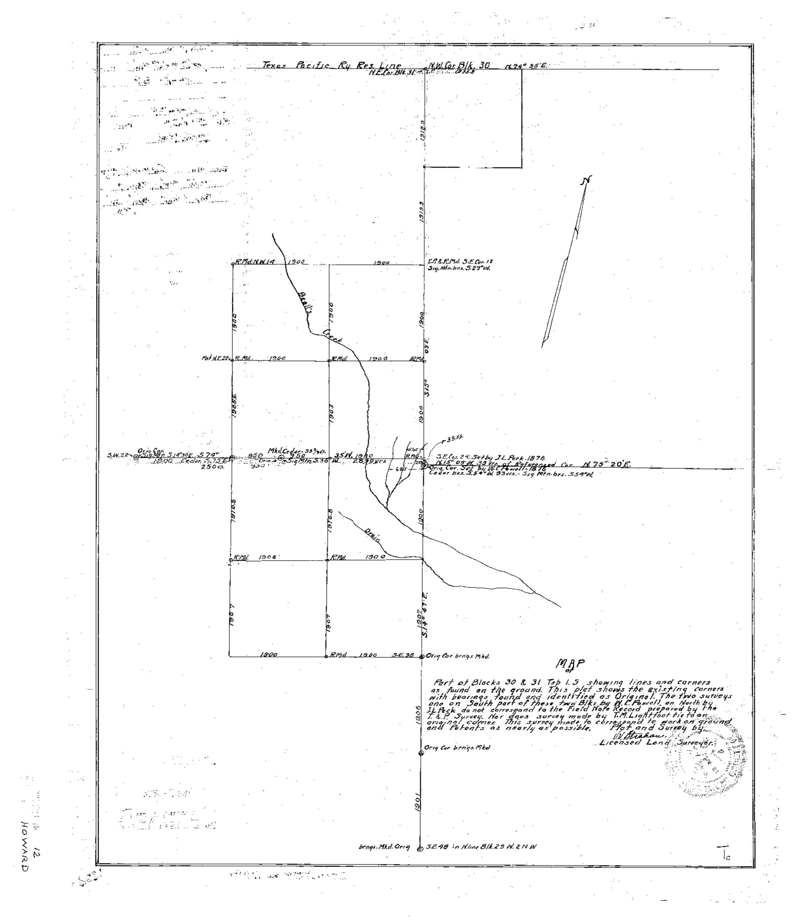
Howard County Sketch File 12
[Portion of Blk. 31 T1S]
-
Map/Doc
11799
-
Collection
General Map Collection
-
Object Dates
4/1/1939 (Creation Date)
4/1/1939 (File Date)
-
People and Organizations
V.V. Strahan (Surveyor/Engineer)
T.M. Lightfoot (Surveyor/Engineer)
-
Counties
Howard
-
Subjects
Surveying Sketch File
-
Height x Width
18.2 x 15.7 inches
46.2 x 39.9 cm
-
Medium
paper, print
-
Features
Beall's Creek
Part of: General Map Collection
Washington County Sketch File 3

Print $4.00
- Digital $50.00
Washington County Sketch File 3
1860
Size 8.1 x 9.2 inches
Map/Doc 39648
Hutchinson County Sketch File 6a

Print $42.00
- Digital $50.00
Hutchinson County Sketch File 6a
1898
Size 7.6 x 8.6 inches
Map/Doc 27202
Crosby County Rolled Sketch 1A

Print $20.00
- Digital $50.00
Crosby County Rolled Sketch 1A
1950
Size 26.1 x 22.2 inches
Map/Doc 5641
Flight Mission No. DQO-8K, Frame 67, Galveston County

Print $20.00
- Digital $50.00
Flight Mission No. DQO-8K, Frame 67, Galveston County
1952
Size 18.9 x 22.4 inches
Map/Doc 85171
Flight Mission No. DAG-23K, Frame 180, Matagorda County

Print $20.00
- Digital $50.00
Flight Mission No. DAG-23K, Frame 180, Matagorda County
1953
Size 18.4 x 16.0 inches
Map/Doc 86515
[Galveston, Harrisburg & San Antonio through El Paso County]
![64013, [Galveston, Harrisburg & San Antonio through El Paso County], General Map Collection](https://historictexasmaps.com/wmedia_w700/maps/64013.tif.jpg)
Print $20.00
- Digital $50.00
[Galveston, Harrisburg & San Antonio through El Paso County]
1906
Size 13.5 x 33.5 inches
Map/Doc 64013
Map of Robertson Co.

Print $20.00
- Digital $50.00
Map of Robertson Co.
1889
Size 44.0 x 39.1 inches
Map/Doc 3996
Marion County Working Sketch 41

Print $40.00
- Digital $50.00
Marion County Working Sketch 41
1996
Size 34.0 x 48.5 inches
Map/Doc 70817
Flight Mission No. CRC-5R, Frame 25, Chambers County

Print $20.00
- Digital $50.00
Flight Mission No. CRC-5R, Frame 25, Chambers County
1956
Size 18.9 x 22.4 inches
Map/Doc 84947
Matagorda Light to Aransas Pass

Print $20.00
- Digital $50.00
Matagorda Light to Aransas Pass
1966
Size 36.0 x 45.0 inches
Map/Doc 73399
Madison County Working Sketch 7

Print $20.00
- Digital $50.00
Madison County Working Sketch 7
1982
Size 12.7 x 17.4 inches
Map/Doc 70769
Rockwall County

Print $20.00
- Digital $50.00
Rockwall County
1941
Size 29.7 x 24.1 inches
Map/Doc 95628
You may also like
Flight Mission No. BRA-8M, Frame 77, Jefferson County

Print $20.00
- Digital $50.00
Flight Mission No. BRA-8M, Frame 77, Jefferson County
1953
Size 15.9 x 15.7 inches
Map/Doc 85597
Coke County Sketch File 6

Print $6.00
- Digital $50.00
Coke County Sketch File 6
1860
Size 7.5 x 10.0 inches
Map/Doc 18582
Culberson County Working Sketch 5

Print $20.00
- Digital $50.00
Culberson County Working Sketch 5
1906
Size 22.2 x 17.2 inches
Map/Doc 68457
Sketch in Crockett County [showing University Land Blocks 42 and 45 and Block A-B]
![90313, Sketch in Crockett County [showing University Land Blocks 42 and 45 and Block A-B], Twichell Survey Records](https://historictexasmaps.com/wmedia_w700/maps/90313-1.tif.jpg)
Print $20.00
- Digital $50.00
Sketch in Crockett County [showing University Land Blocks 42 and 45 and Block A-B]
1913
Size 24.6 x 11.9 inches
Map/Doc 90313
Crockett County Sketch File 67

Print $20.00
- Digital $50.00
Crockett County Sketch File 67
1927
Size 30.1 x 26.6 inches
Map/Doc 11231
Pecan Bayou Travis District

Print $20.00
- Digital $50.00
Pecan Bayou Travis District
1852
Size 25.8 x 20.5 inches
Map/Doc 4518
[Sketch for Mineral Application 24072, San Jacinto River]
![65585, [Sketch for Mineral Application 24072, San Jacinto River], General Map Collection](https://historictexasmaps.com/wmedia_w700/maps/65585.tif.jpg)
Print $20.00
- Digital $50.00
[Sketch for Mineral Application 24072, San Jacinto River]
1929
Size 21.7 x 11.1 inches
Map/Doc 65585

Atascosa County Sketch File 4

Print $7.00
- Digital $50.00
Atascosa County Sketch File 4
1854
Size 8.1 x 6.5 inches
Map/Doc 13745
Montgomery County Sketch File 36a

Print $8.00
- Digital $50.00
Montgomery County Sketch File 36a
1953
Size 14.4 x 8.8 inches
Map/Doc 31912
Blocks 3 and 4 Capitol Syndicate Subdivision of Capitol Leagues 93, 94, 95, 96, 104, 105, 106, 107, 116, 117, 118, 127, 128, 129, 130, 131, 132, 140, 141, 142, and Parts of 75, 83, 84, 85, 86, 108, 143, 144, and 145

Print $20.00
- Digital $50.00
Blocks 3 and 4 Capitol Syndicate Subdivision of Capitol Leagues 93, 94, 95, 96, 104, 105, 106, 107, 116, 117, 118, 127, 128, 129, 130, 131, 132, 140, 141, 142, and Parts of 75, 83, 84, 85, 86, 108, 143, 144, and 145
1906
Size 18.1 x 29.2 inches
Map/Doc 92582
Presidio County Working Sketch 35

Print $20.00
- Digital $50.00
Presidio County Working Sketch 35
1947
Size 25.7 x 47.3 inches
Map/Doc 71712