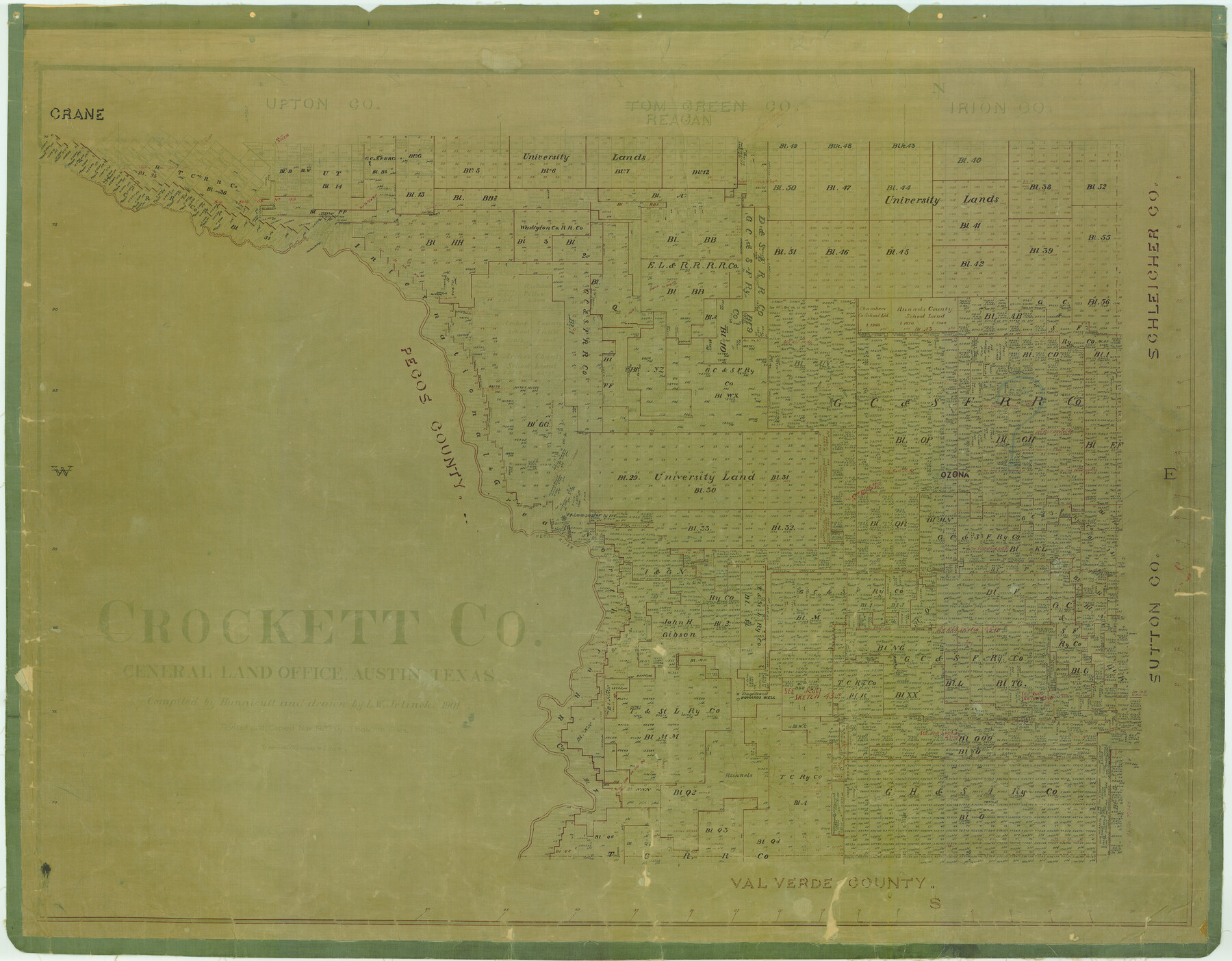
Crockett Co.
-
Map/Doc
4728
-
Collection
General Map Collection
-
Object Dates
1901 (Creation Date)
-
People and Organizations
Texas General Land Office (Publisher)
Hunnicutt (Compiler)
L.W. Jelinek (Draftsman)
-
Counties
Crockett
-
Subjects
County
-
Height x Width
35.5 x 45.5 inches
90.2 x 115.6 cm
-
Comments
Revised and copied in November 1920 by J. Bascom Giles.
Copy No. 1.
Help Save Texas History - Adopt Me! -
Features
Howards Well
Pontoon Bridge
I&GN
Johnson Run Creek
Ozona
Fort Lancaster
Pecos River
Part of: General Map Collection
Williamson County Sketch File 4

Print $26.00
- Digital $50.00
Williamson County Sketch File 4
1849
Size 15.9 x 10.4 inches
Map/Doc 40304
Kerr County State Real Property Sketch 2

Print $2.00
- Digital $50.00
Kerr County State Real Property Sketch 2
2007
Size 10.7 x 8.6 inches
Map/Doc 88675
Garza County Working Sketch Graphic Index

Print $20.00
- Digital $50.00
Garza County Working Sketch Graphic Index
1928
Size 46.7 x 36.2 inches
Map/Doc 76552
McMullen County Sketch File 30

Print $20.00
- Digital $50.00
McMullen County Sketch File 30
1884
Size 38.5 x 21.1 inches
Map/Doc 10540
Lipscomb County Boundary File 1

Print $16.00
- Digital $50.00
Lipscomb County Boundary File 1
Size 9.0 x 8.0 inches
Map/Doc 56307
Culberson County Working Sketch 47

Print $20.00
- Digital $50.00
Culberson County Working Sketch 47
1971
Size 25.7 x 36.5 inches
Map/Doc 68501
Flight Mission No. DIX-6P, Frame 198, Aransas County

Print $20.00
- Digital $50.00
Flight Mission No. DIX-6P, Frame 198, Aransas County
1956
Size 19.1 x 22.9 inches
Map/Doc 83860
Sabine County Sketch File 6b

Print $4.00
Sabine County Sketch File 6b
1879
Size 8.1 x 9.0 inches
Map/Doc 35617
Aransas County Rolled Sketch 6

Print $20.00
- Digital $50.00
Aransas County Rolled Sketch 6
1953
Size 19.6 x 18.8 inches
Map/Doc 77190
Map of Castro County

Print $20.00
- Digital $50.00
Map of Castro County
1900
Size 43.0 x 37.3 inches
Map/Doc 4906
Coke County Working Sketch 28

Print $20.00
- Digital $50.00
Coke County Working Sketch 28
1965
Size 32.7 x 42.2 inches
Map/Doc 68065
Karnes County Boundary File 2a

Print $4.00
- Digital $50.00
Karnes County Boundary File 2a
Size 12.7 x 8.1 inches
Map/Doc 55692
You may also like
Knox County Rolled Sketch 22

Print $20.00
- Digital $50.00
Knox County Rolled Sketch 22
1968
Size 25.4 x 37.6 inches
Map/Doc 6562
Briscoe County Working Sketch 2

Print $20.00
- Digital $50.00
Briscoe County Working Sketch 2
1913
Size 25.4 x 23.9 inches
Map/Doc 67805
Plat of South Side Addition on Section 37 Block 17, Wheeler County, Texas

Print $20.00
- Digital $50.00
Plat of South Side Addition on Section 37 Block 17, Wheeler County, Texas
Size 12.0 x 16.9 inches
Map/Doc 92103
Atascosa County Rolled Sketch 9

Print $20.00
- Digital $50.00
Atascosa County Rolled Sketch 9
1905
Size 34.5 x 26.9 inches
Map/Doc 5093
General Highway Map, Harris County, Texas

Print $20.00
General Highway Map, Harris County, Texas
1939
Size 25.3 x 18.7 inches
Map/Doc 79116
Crockett County Rolled Sketch 95

Print $20.00
- Digital $50.00
Crockett County Rolled Sketch 95
1985
Size 24.6 x 28.8 inches
Map/Doc 5634
Nueces County Rolled Sketch 122

Print $47.00
Nueces County Rolled Sketch 122
1996
Size 24.6 x 40.2 inches
Map/Doc 7153
Duval County Rolled Sketch 26
Print $20.00
- Digital $50.00
Duval County Rolled Sketch 26
1945
Size 21.2 x 20.0 inches
Map/Doc 5744
General Highway Map, Terry County, Texas

Print $20.00
General Highway Map, Terry County, Texas
1940
Size 18.5 x 24.9 inches
Map/Doc 79257
La Salle County Boundary File 57

Print $26.00
- Digital $50.00
La Salle County Boundary File 57
Size 9.2 x 4.7 inches
Map/Doc 56242
Concho County Rolled Sketch 11

Print $20.00
- Digital $50.00
Concho County Rolled Sketch 11
1957
Size 29.5 x 34.5 inches
Map/Doc 5569
Flight Mission No. DCL-5C, Frame 2, Kenedy County

Print $20.00
- Digital $50.00
Flight Mission No. DCL-5C, Frame 2, Kenedy County
1943
Size 18.5 x 22.5 inches
Map/Doc 85827