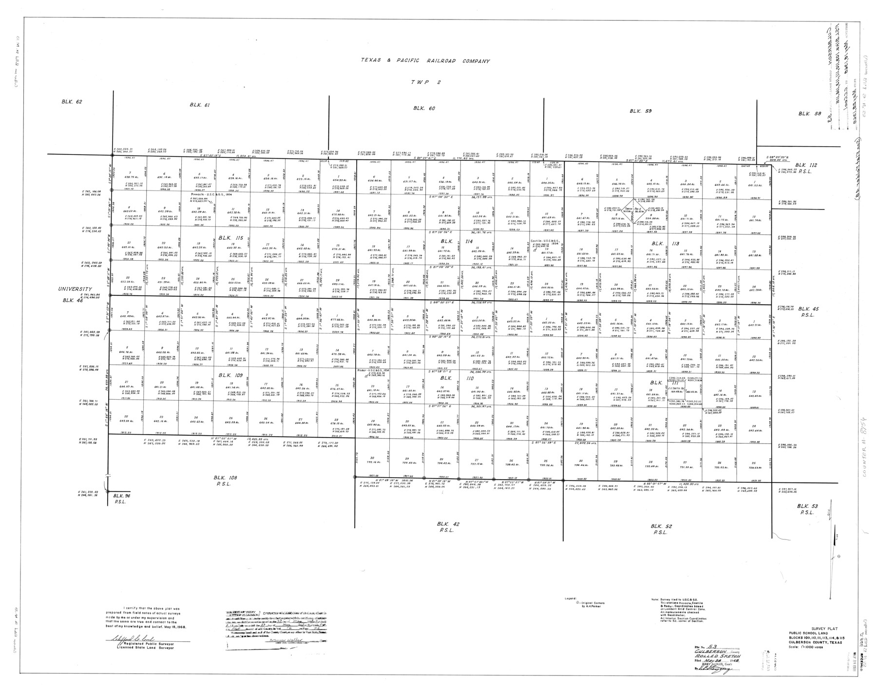
Culberson County Rolled Sketch 53
Survey plat, Public School Land Blocks 109, 110, 111, 113, 114, & 115
-
Map/Doc
8756
-
Collection
General Map Collection
-
Object Dates
5/18/1968 (Creation Date)
5/28/1968 (File Date)
-
People and Organizations
Clifford C. Cool (Surveyor/Engineer)
-
Counties
Culberson
-
Subjects
Surveying Rolled Sketch
-
Height x Width
36.7 x 47.2 inches
93.2 x 119.9 cm
-
Scale
1" = 1000 varas
-
Comments
See Culberson County Rolled Sketch 48 (45339) for related material and Culberson County Rolled Sketch 54 (10300) for another related sketch.
Related maps
Culberson County Rolled Sketch 54

Print $40.00
- Digital $50.00
Culberson County Rolled Sketch 54
1968
Size 59.0 x 29.4 inches
Map/Doc 10300
Culberson County Rolled Sketch 48

Print $335.00
- Digital $50.00
Culberson County Rolled Sketch 48
1960
Size 11.0 x 15.4 inches
Map/Doc 45339
Part of: General Map Collection

McMullen County Boundary File 1

Print $16.00
- Digital $50.00
McMullen County Boundary File 1
Size 8.7 x 4.0 inches
Map/Doc 57009
Flight Mission No. DCL-5C, Frame 73, Kenedy County

Print $20.00
- Digital $50.00
Flight Mission No. DCL-5C, Frame 73, Kenedy County
1943
Size 18.5 x 22.2 inches
Map/Doc 85856
Zavalla [sic] County
![16939, Zavalla [sic] County, General Map Collection](https://historictexasmaps.com/wmedia_w700/maps/16939.tif.jpg)
Print $20.00
- Digital $50.00
Zavalla [sic] County
1893
Size 44.5 x 46.3 inches
Map/Doc 16939
Flight Mission No. DQN-7K, Frame 31, Calhoun County

Print $20.00
- Digital $50.00
Flight Mission No. DQN-7K, Frame 31, Calhoun County
1953
Size 18.5 x 22.1 inches
Map/Doc 84469
Galveston County Working Sketch 17

Print $20.00
- Digital $50.00
Galveston County Working Sketch 17
1982
Size 15.5 x 14.3 inches
Map/Doc 69354
Flight Mission No. DAG-26K, Frame 56, Matagorda County

Print $20.00
- Digital $50.00
Flight Mission No. DAG-26K, Frame 56, Matagorda County
1953
Size 18.6 x 22.7 inches
Map/Doc 86576
Reagan County Rolled Sketch FF

Print $20.00
- Digital $50.00
Reagan County Rolled Sketch FF
Size 35.0 x 17.8 inches
Map/Doc 7451
Dimmit County Boundary File 2

Print $4.00
- Digital $50.00
Dimmit County Boundary File 2
Size 10.0 x 7.9 inches
Map/Doc 52564
[Sketch for Mineral Application 26546 - Sabine River between Hawkins Creek and east boundary line of BBB&C RR Co. Surveys, R. S. Rathke]
![65665, [Sketch for Mineral Application 26546 - Sabine River between Hawkins Creek and east boundary line of BBB&C RR Co. Surveys, R. S. Rathke], General Map Collection](https://historictexasmaps.com/wmedia_w700/maps/65665.tif.jpg)
Print $40.00
- Digital $50.00
[Sketch for Mineral Application 26546 - Sabine River between Hawkins Creek and east boundary line of BBB&C RR Co. Surveys, R. S. Rathke]
1931
Size 25.5 x 75.1 inches
Map/Doc 65665
Johnson County Working Sketch 19

Print $20.00
- Digital $50.00
Johnson County Working Sketch 19
1990
Size 35.2 x 42.5 inches
Map/Doc 66632
Wichita County Rolled Sketch 14A

Print $40.00
- Digital $50.00
Wichita County Rolled Sketch 14A
Size 28.0 x 59.9 inches
Map/Doc 10138
You may also like
Gaines County Rolled Sketch 7

Print $40.00
- Digital $50.00
Gaines County Rolled Sketch 7
1915
Size 35.7 x 54.0 inches
Map/Doc 9014
El Paso County Working Sketch 35

Print $20.00
- Digital $50.00
El Paso County Working Sketch 35
1977
Size 19.8 x 30.3 inches
Map/Doc 69057
Maps of Gulf Intracoastal Waterway, Texas - Sabine River to the Rio Grande and connecting waterways including ship channels

Print $20.00
- Digital $50.00
Maps of Gulf Intracoastal Waterway, Texas - Sabine River to the Rio Grande and connecting waterways including ship channels
1966
Size 14.6 x 21.6 inches
Map/Doc 61982
Kimble County Rolled Sketch 28

Print $20.00
- Digital $50.00
Kimble County Rolled Sketch 28
1964
Size 19.7 x 20.6 inches
Map/Doc 6518
Reagan County Working Sketch 11

Print $20.00
- Digital $50.00
Reagan County Working Sketch 11
1943
Size 19.4 x 20.9 inches
Map/Doc 71851
Brewster County Rolled Sketch 122

Print $20.00
- Digital $50.00
Brewster County Rolled Sketch 122
1974
Size 32.0 x 25.5 inches
Map/Doc 5297
San Jacinto Co.

Print $20.00
- Digital $50.00
San Jacinto Co.
1889
Size 46.4 x 37.9 inches
Map/Doc 63016
Hudspeth County Sketch File 13

Print $18.00
- Digital $50.00
Hudspeth County Sketch File 13
1915
Size 13.3 x 8.9 inches
Map/Doc 26929
Briscoe County Rolled Sketch 14A

Print $40.00
- Digital $50.00
Briscoe County Rolled Sketch 14A
1913
Size 34.6 x 48.1 inches
Map/Doc 8530
Flight Mission No. DCL-5C, Frame 4, Kenedy County

Print $20.00
- Digital $50.00
Flight Mission No. DCL-5C, Frame 4, Kenedy County
1943
Size 18.6 x 22.5 inches
Map/Doc 85829
Donley County Rolled Sketch 2

Print $20.00
- Digital $50.00
Donley County Rolled Sketch 2
Size 41.8 x 34.3 inches
Map/Doc 8800
Duval County Rolled Sketch 37

Print $20.00
- Digital $50.00
Duval County Rolled Sketch 37
Size 19.8 x 16.5 inches
Map/Doc 5754