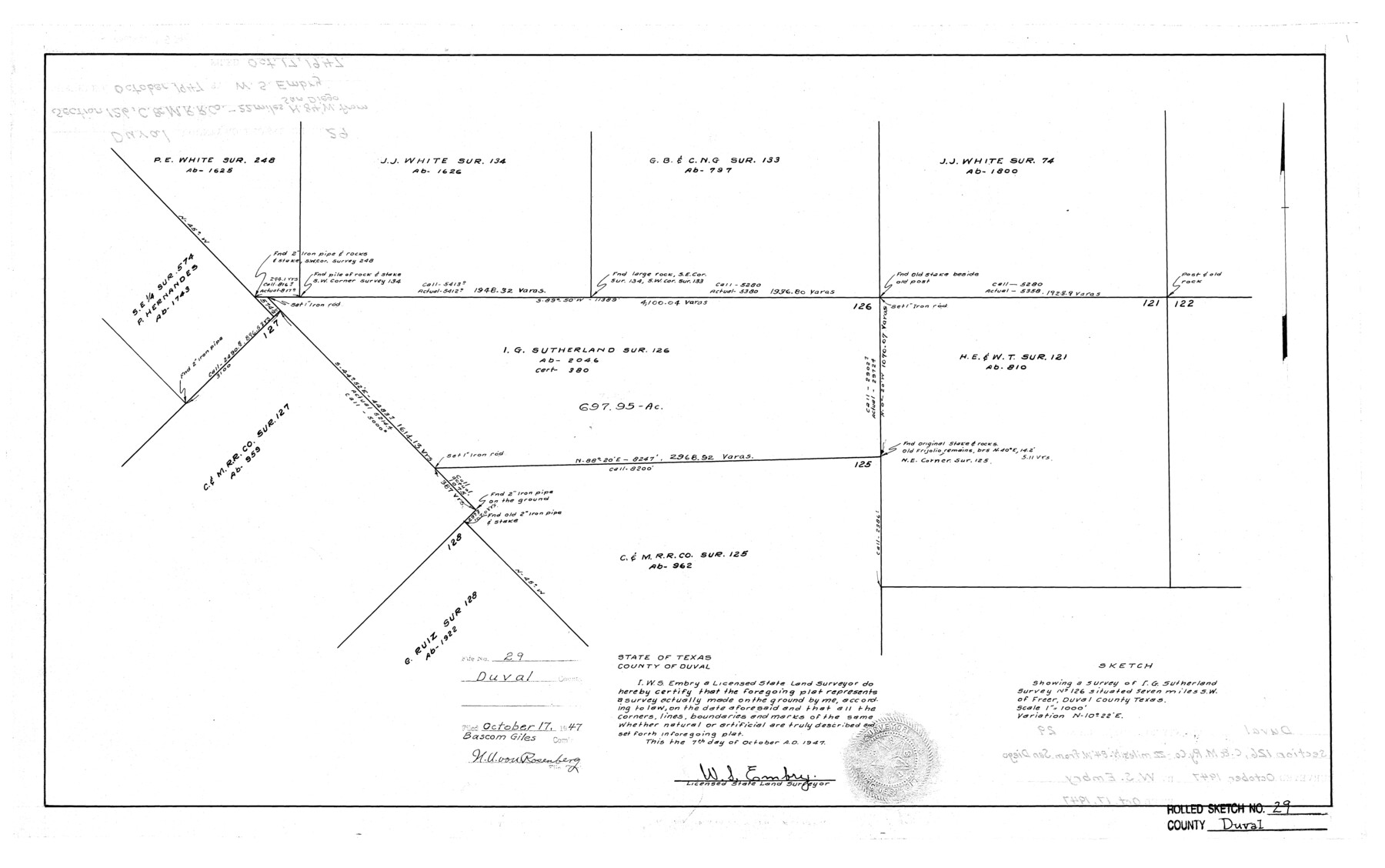
Duval County Rolled Sketch 29
Sketch showing a survey of I.G. Sutherland survey no. 126
-
Map/Doc
5746
-
Collection
General Map Collection
-
Object Dates
1947/10/7 (Creation Date)
1947/10/17 (File Date)
-
People and Organizations
W.S. Embry (Surveyor/Engineer)
-
Counties
Duval
-
Subjects
Surveying Rolled Sketch
-
Height x Width
16.2 x 25.8 inches
41.1 x 65.5 cm
-
Scale
1" = 1000 feet
Part of: General Map Collection
Map of Van Zandt County

Print $20.00
- Digital $50.00
Map of Van Zandt County
1853
Size 19.4 x 20.6 inches
Map/Doc 16957
Pecos County Rolled Sketch 146

Print $20.00
- Digital $50.00
Pecos County Rolled Sketch 146
Size 40.8 x 32.5 inches
Map/Doc 9734
Flight Mission No. DQO-3K, Frame 22, Galveston County

Print $20.00
- Digital $50.00
Flight Mission No. DQO-3K, Frame 22, Galveston County
1952
Size 18.8 x 22.5 inches
Map/Doc 85063
Irion County Rolled Sketch 3

Print $20.00
- Digital $50.00
Irion County Rolled Sketch 3
Size 26.2 x 27.5 inches
Map/Doc 6318
Gaines County Working Sketch 34

Print $20.00
- Digital $50.00
Gaines County Working Sketch 34
1990
Size 21.0 x 20.2 inches
Map/Doc 69334
Presidio County Working Sketch 74

Print $20.00
- Digital $50.00
Presidio County Working Sketch 74
1962
Size 45.9 x 35.2 inches
Map/Doc 71751
Wichita County

Print $20.00
- Digital $50.00
Wichita County
1971
Size 35.8 x 37.7 inches
Map/Doc 77457
Edwards County Sketch File 40

Print $20.00
- Digital $50.00
Edwards County Sketch File 40
1940
Size 20.4 x 14.3 inches
Map/Doc 11438
Kinney County Sketch File 5

Print $2.00
- Digital $50.00
Kinney County Sketch File 5
Size 5.7 x 13.1 inches
Map/Doc 29123
St. Louis, Brownsville & Mexico Railway Location Map from Mile 0 to Mile 20

Print $40.00
- Digital $50.00
St. Louis, Brownsville & Mexico Railway Location Map from Mile 0 to Mile 20
1906
Size 19.5 x 74.5 inches
Map/Doc 64075

Ward County Working Sketch Graphic Index - sheet A

Print $40.00
- Digital $50.00
Ward County Working Sketch Graphic Index - sheet A
1932
Size 30.8 x 52.8 inches
Map/Doc 76731
You may also like
[Unidentified Railroad through Denton and Dallas County]
![64775, [Unidentified Railroad through Denton and Dallas County], General Map Collection](https://historictexasmaps.com/wmedia_w700/maps/64775.tif.jpg)
Print $40.00
- Digital $50.00
[Unidentified Railroad through Denton and Dallas County]
Size 6.8 x 73.3 inches
Map/Doc 64775
Plot of surveys on Sims Bayou

Print $2.00
- Digital $50.00
Plot of surveys on Sims Bayou
1844
Size 6.8 x 8.3 inches
Map/Doc 26
The Judicial District/County of Burleson. Created, January 15, 1842

Print $20.00
The Judicial District/County of Burleson. Created, January 15, 1842
2020
Size 14.1 x 21.7 inches
Map/Doc 96320
Flight Mission No. CUG-1P, Frame 69, Kleberg County

Print $20.00
- Digital $50.00
Flight Mission No. CUG-1P, Frame 69, Kleberg County
1956
Size 18.6 x 22.3 inches
Map/Doc 86134
Surveys made on the San Miguel. March 1847

Print $2.00
- Digital $50.00
Surveys made on the San Miguel. March 1847
1847
Size 10.4 x 8.4 inches
Map/Doc 223
Zapata County Rolled Sketch 9

Print $20.00
- Digital $50.00
Zapata County Rolled Sketch 9
1912
Size 15.0 x 15.5 inches
Map/Doc 8310
[T. & G. Ry. Main Line, Texas, Right of Way Map, Center to Gary]
![64569, [T. & G. Ry. Main Line, Texas, Right of Way Map, Center to Gary], General Map Collection](https://historictexasmaps.com/wmedia_w700/maps/64569.tif.jpg)
Print $40.00
- Digital $50.00
[T. & G. Ry. Main Line, Texas, Right of Way Map, Center to Gary]
1917
Size 31.5 x 76.7 inches
Map/Doc 64569
Flight Mission No. DAG-17K, Frame 121, Matagorda County

Print $20.00
- Digital $50.00
Flight Mission No. DAG-17K, Frame 121, Matagorda County
1952
Size 16.4 x 16.5 inches
Map/Doc 86341
Flight Mission No. BQY-4M, Frame 116, Harris County

Print $20.00
- Digital $50.00
Flight Mission No. BQY-4M, Frame 116, Harris County
1953
Size 18.5 x 22.4 inches
Map/Doc 85283
County of Galveston, Texas

Print $20.00
- Digital $50.00
County of Galveston, Texas
1845
Size 22.9 x 32.2 inches
Map/Doc 3574
Maps & Lists Showing Prison Lands (Oil & Gas) Leased as of June 1955

Digital $50.00
Maps & Lists Showing Prison Lands (Oil & Gas) Leased as of June 1955
1934
Size 29.6 x 38.1 inches
Map/Doc 62880
Frio County Sketch File 20

Print $6.00
- Digital $50.00
Frio County Sketch File 20
1964
Size 14.2 x 8.8 inches
Map/Doc 23159