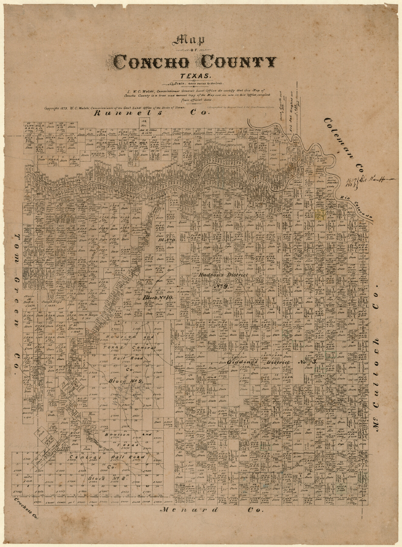
Map of Concho County, Texas
-
Map/Doc
703
-
Collection
Maddox Collection
-
Object Dates
1879 (Creation Date)
-
People and Organizations
General Land Office (Publisher)
W.C. Walsh (GLO Commissioner)
August Gast & Co. (Lithographer)
-
Counties
Concho
-
Subjects
County
-
Height x Width
28.8 x 23.9 inches
73.2 x 60.7 cm
-
Medium
paper, etching/engraving/lithograph
-
Scale
1" = 4000 varas
-
Comments
Conservation funded in 2011 by Friends of the Texas General Land Office.
"Lithographed by August Gast & new process. St. Louis" -
Features
Rio Colorado
Concho River
Cottonwood Creek
Kolb Creek
Kicapoo Creek
Brady's Creek
Claus Creek
South Prong of Brady's Creek
Part of: Maddox Collection
Working Sketch in Dickens and Crosby Cos.

Print $20.00
- Digital $50.00
Working Sketch in Dickens and Crosby Cos.
1910
Size 36.1 x 24.8 inches
Map/Doc 10771
[Surveying Sketch of John Knight, Champion Choate, A.M. Lejarza, et al in Hardin County, Texas - Exhibit "G"]
![75822, [Surveying Sketch of John Knight, Champion Choate, A.M. Lejarza, et al in Hardin County, Texas - Exhibit "G"], Maddox Collection](https://historictexasmaps.com/wmedia_w700/maps/75822.tif.jpg)
Print $20.00
- Digital $50.00
[Surveying Sketch of John Knight, Champion Choate, A.M. Lejarza, et al in Hardin County, Texas - Exhibit "G"]
Size 18.3 x 23.5 inches
Map/Doc 75822
Johnson County, Texas

Print $20.00
- Digital $50.00
Johnson County, Texas
1871
Size 18.2 x 23.3 inches
Map/Doc 734
Knox County, Texas

Print $20.00
- Digital $50.00
Knox County, Texas
1880
Size 27.7 x 23.4 inches
Map/Doc 550
Bee County, Texas

Print $20.00
- Digital $50.00
Bee County, Texas
1879
Size 25.5 x 21.7 inches
Map/Doc 510
[Dennis Corwin's Map of Survey for R. N. Graham]
![83427, [Dennis Corwin's Map of Survey for R. N. Graham], Maddox Collection](https://historictexasmaps.com/wmedia_w700/maps/83427.tif.jpg)
Print $2.00
- Digital $50.00
[Dennis Corwin's Map of Survey for R. N. Graham]
Size 11.1 x 8.5 inches
Map/Doc 83427
Sketch in NE Portion Hutchinson County

Print $20.00
- Digital $50.00
Sketch in NE Portion Hutchinson County
1913
Size 36.9 x 43.3 inches
Map/Doc 75815
Austin County, Texas

Print $20.00
- Digital $50.00
Austin County, Texas
1879
Size 23.5 x 28.8 inches
Map/Doc 689
[Mary L. Williams or Lydia Glasgow Survey, Bastrop County, Texas]
![572, [Mary L. Williams or Lydia Glasgow Survey, Bastrop County, Texas], Maddox Collection](https://historictexasmaps.com/wmedia_w700/maps/0572-1.tif.jpg)
Print $3.00
- Digital $50.00
[Mary L. Williams or Lydia Glasgow Survey, Bastrop County, Texas]
Size 11.9 x 15.6 inches
Map/Doc 572
[Unknown Building Sketch]
![75794, [Unknown Building Sketch], Maddox Collection](https://historictexasmaps.com/wmedia_w700/maps/75794.tif.jpg)
Print $20.00
- Digital $50.00
[Unknown Building Sketch]
Size 17.1 x 22.6 inches
Map/Doc 75794
Map of SW portion of Hale Co., Texas

Print $3.00
- Digital $50.00
Map of SW portion of Hale Co., Texas
Size 12.7 x 10.8 inches
Map/Doc 518
[Surveying Sketch of Northern Portion of Hutchinson County]
![5065, [Surveying Sketch of Northern Portion of Hutchinson County], Maddox Collection](https://historictexasmaps.com/wmedia_w700/maps/5065.tif.jpg)
Print $20.00
- Digital $50.00
[Surveying Sketch of Northern Portion of Hutchinson County]
1890
Size 26.5 x 42.5 inches
Map/Doc 5065
You may also like
Maps of Gulf Intracoastal Waterway, Texas - Sabine River to the Rio Grande and connecting waterways including ship channels

Print $20.00
- Digital $50.00
Maps of Gulf Intracoastal Waterway, Texas - Sabine River to the Rio Grande and connecting waterways including ship channels
1966
Size 14.5 x 22.3 inches
Map/Doc 61977
Ellis County Working Sketch 5

Print $40.00
- Digital $50.00
Ellis County Working Sketch 5
1997
Size 49.2 x 32.4 inches
Map/Doc 69021
Official Highway Map of Texas

Print $20.00
Official Highway Map of Texas
1928
Size 42.3 x 46.2 inches
Map/Doc 79746
Aransas County Sketch File 37

Print $139.00
- Digital $50.00
Aransas County Sketch File 37
1995
Size 11.1 x 9.1 inches
Map/Doc 13413
Shores of Nueces Bay, Texas

Print $40.00
- Digital $50.00
Shores of Nueces Bay, Texas
1882
Size 33.0 x 54.3 inches
Map/Doc 73464
Presidio County Rolled Sketch D3

Print $40.00
- Digital $50.00
Presidio County Rolled Sketch D3
1909
Size 57.2 x 38.5 inches
Map/Doc 9776
[Blocks N and B]
![90498, [Blocks N and B], Twichell Survey Records](https://historictexasmaps.com/wmedia_w700/maps/90498-1.tif.jpg)
Print $3.00
- Digital $50.00
[Blocks N and B]
Size 10.0 x 11.4 inches
Map/Doc 90498
A New Map of Texas

Print $20.00
- Digital $50.00
A New Map of Texas
1841
Size 17.6 x 16.2 inches
Map/Doc 93862
Childress County Rolled Sketch 16B

Print $40.00
- Digital $50.00
Childress County Rolled Sketch 16B
Size 26.3 x 78.1 inches
Map/Doc 8600
Flight Mission No. DQN-5K, Frame 59, Calhoun County

Print $20.00
- Digital $50.00
Flight Mission No. DQN-5K, Frame 59, Calhoun County
1953
Size 18.7 x 22.3 inches
Map/Doc 84402
Hutchinson County Working Sketch 19

Print $20.00
- Digital $50.00
Hutchinson County Working Sketch 19
1960
Size 18.8 x 18.3 inches
Map/Doc 66379
Sterling County Rolled Sketch 18

Print $20.00
- Digital $50.00
Sterling County Rolled Sketch 18
Size 34.6 x 35.9 inches
Map/Doc 9950