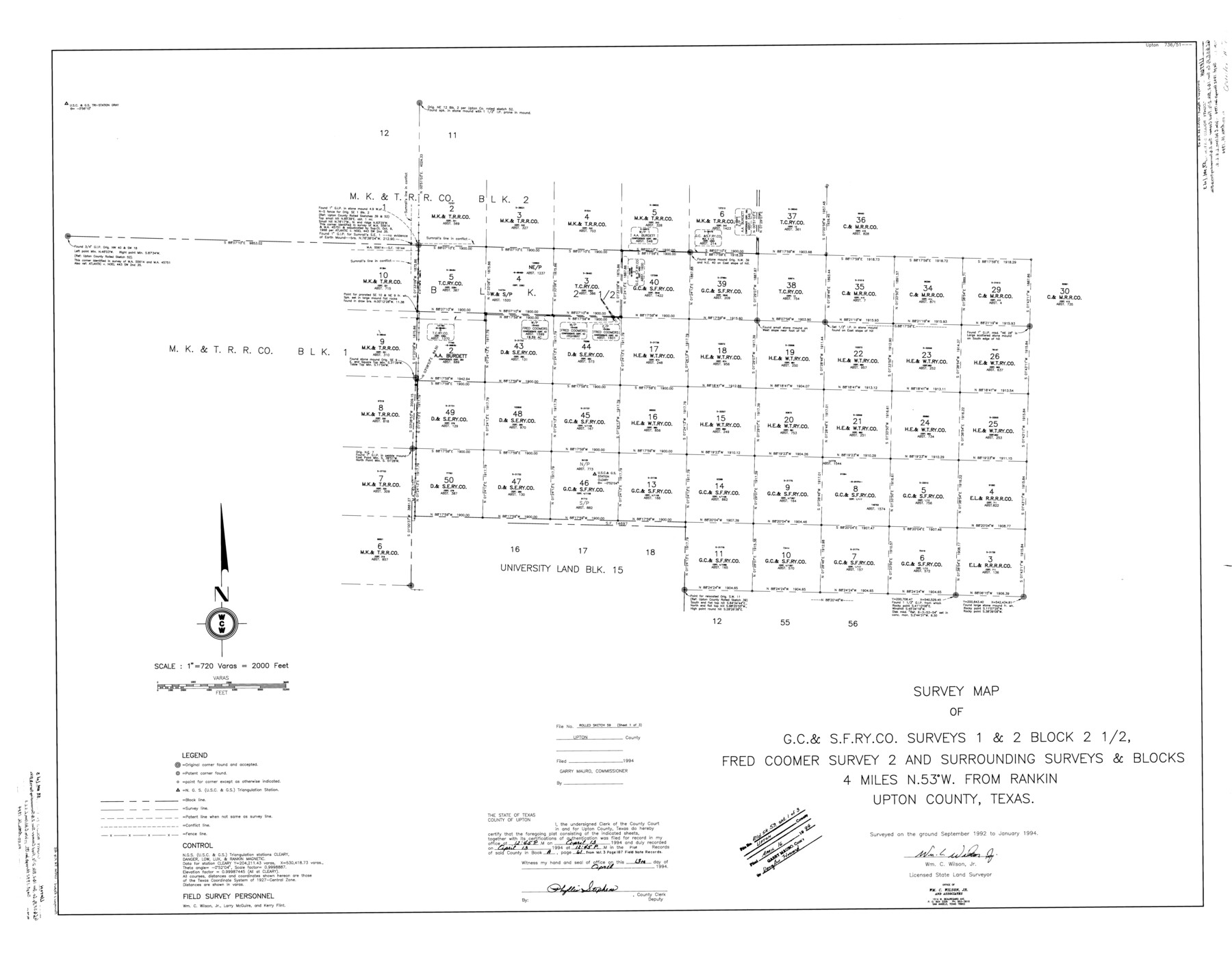
Upton County Rolled Sketch 59
Survey map of G. C. & S. F. Ry. Co. surveys 1 & 2, Block 2 1/2, Fred Coomer survey 2 and surrounding surveys & Blocks
-
Map/Doc
10062
-
Collection
General Map Collection
-
Object Dates
1994 (Survey Date)
1994/4/16 (File Date)
-
People and Organizations
Wm. C. Wilson, Jr. (Surveyor/Engineer)
-
Counties
Upton
-
Subjects
Surveying Rolled Sketch
-
Height x Width
37.8 x 48.4 inches
96.0 x 122.9 cm
-
Medium
mylar, print
-
Scale
1" = 720 varas
-
Comments
Sheet 1 of 3. See Upton County Sketch File 45 (38933) for report.
Related maps
Upton County Sketch File 45

Print $20.00
- Digital $50.00
Upton County Sketch File 45
1994
Size 11.3 x 8.8 inches
Map/Doc 38933
Part of: General Map Collection
Terrell County Rolled Sketch 27

Print $20.00
- Digital $50.00
Terrell County Rolled Sketch 27
Size 24.8 x 20.7 inches
Map/Doc 7934
Brewster County Rolled Sketch 152

Print $20.00
- Digital $50.00
Brewster County Rolled Sketch 152
1996
Size 28.0 x 36.5 inches
Map/Doc 5319
Map of Parker County

Print $20.00
- Digital $50.00
Map of Parker County
1879
Size 23.9 x 19.0 inches
Map/Doc 3947
Milam County Working Sketch 17

Print $40.00
- Digital $50.00
Milam County Working Sketch 17
1972
Size 54.7 x 32.2 inches
Map/Doc 89031
Map of Upton County

Print $20.00
- Digital $50.00
Map of Upton County
1889
Size 23.4 x 21.4 inches
Map/Doc 4104
Johnson County Working Sketch 16

Print $20.00
- Digital $50.00
Johnson County Working Sketch 16
1981
Size 37.3 x 38.0 inches
Map/Doc 66629
Upshur County Rolled Sketch 5

Print $20.00
- Digital $50.00
Upshur County Rolled Sketch 5
2000
Size 35.2 x 24.4 inches
Map/Doc 8064
McCulloch County Working Sketch 14

Print $20.00
- Digital $50.00
McCulloch County Working Sketch 14
1990
Size 15.3 x 29.0 inches
Map/Doc 70689
Reeves County Working Sketch 47

Print $20.00
- Digital $50.00
Reeves County Working Sketch 47
1974
Size 45.8 x 24.6 inches
Map/Doc 63490
Howard County Boundary File 4b

Print $24.00
- Digital $50.00
Howard County Boundary File 4b
Size 11.3 x 8.9 inches
Map/Doc 55168
Fisher County Rolled Sketch Y

Print $20.00
- Digital $50.00
Fisher County Rolled Sketch Y
Size 42.1 x 25.4 inches
Map/Doc 5878

You may also like
Lamb County Boundary File 3

Print $10.00
- Digital $50.00
Lamb County Boundary File 3
Size 11.4 x 8.9 inches
Map/Doc 56079
Hardin County Working Sketch 17

Print $20.00
- Digital $50.00
Hardin County Working Sketch 17
1942
Size 18.4 x 12.6 inches
Map/Doc 63415
Comanche County Working Sketch 21

Print $20.00
- Digital $50.00
Comanche County Working Sketch 21
1973
Size 28.0 x 26.1 inches
Map/Doc 68155
Flight Mission No. DQO-8K, Frame 46, Galveston County

Print $20.00
- Digital $50.00
Flight Mission No. DQO-8K, Frame 46, Galveston County
1952
Size 18.7 x 22.4 inches
Map/Doc 85153
Sulphur River, Bassett Sheet

Print $20.00
- Digital $50.00
Sulphur River, Bassett Sheet
1939
Size 25.3 x 32.0 inches
Map/Doc 78320
Val Verde County Working Sketch 82

Print $20.00
- Digital $50.00
Val Verde County Working Sketch 82
1973
Size 42.1 x 33.1 inches
Map/Doc 72217
[H. & G. N. Block 8 showing Llano and Espuella fence lines]
![90375, [H. & G. N. Block 8 showing Llano and Espuella fence lines], Twichell Survey Records](https://historictexasmaps.com/wmedia_w700/maps/90375-1.tif.jpg)
Print $2.00
- Digital $50.00
[H. & G. N. Block 8 showing Llano and Espuella fence lines]
Size 8.7 x 11.0 inches
Map/Doc 90375
Hardin County Sketch File 9a

Print $4.00
- Digital $50.00
Hardin County Sketch File 9a
1860
Size 9.9 x 8.4 inches
Map/Doc 25108
The California Case

Print $20.00
- Digital $50.00
The California Case
Size 17.9 x 12.6 inches
Map/Doc 91697
McMullen County Working Sketch 48

Print $20.00
- Digital $50.00
McMullen County Working Sketch 48
1983
Size 27.7 x 19.1 inches
Map/Doc 70749
[Sketch of Unknown Area in New Mexico]
![93027, [Sketch of Unknown Area in New Mexico], Twichell Survey Records](https://historictexasmaps.com/wmedia_w700/maps/93027-1.tif.jpg)
Print $40.00
- Digital $50.00
[Sketch of Unknown Area in New Mexico]
Size 50.6 x 37.1 inches
Map/Doc 93027
Old Miscellaneous File 15

Print $12.00
- Digital $50.00
Old Miscellaneous File 15
1905
Size 11.0 x 7.8 inches
Map/Doc 75451