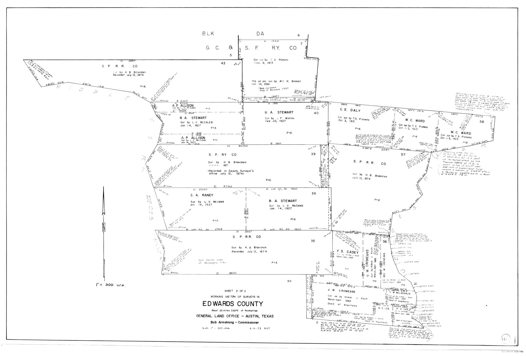
Edwards County Working Sketch 116
-
Map/Doc
68992
-
Collection
General Map Collection
-
Object Dates
6/15/1973 (Creation Date)
-
People and Organizations
Abner G. Trigg (Draftsman)
-
Counties
Edwards
-
Subjects
Surveying Working Sketch
-
Height x Width
26.5 x 39.1 inches
67.3 x 99.3 cm
-
Scale
1" = 300 varas
Part of: General Map Collection
Baylor County Aerial Photograph Index Sheet 2

Print $20.00
- Digital $50.00
Baylor County Aerial Photograph Index Sheet 2
1950
Size 22.2 x 15.4 inches
Map/Doc 83664
Lynn County Boundary File 7b

Print $8.00
- Digital $50.00
Lynn County Boundary File 7b
Size 11.3 x 8.6 inches
Map/Doc 56651
Blanco County Working Sketch 2

Print $20.00
- Digital $50.00
Blanco County Working Sketch 2
Size 26.6 x 20.5 inches
Map/Doc 67361
Flight Mission No. DCL-6C, Frame 127, Kenedy County

Print $20.00
- Digital $50.00
Flight Mission No. DCL-6C, Frame 127, Kenedy County
1943
Size 18.5 x 22.3 inches
Map/Doc 85957
Orange County Working Sketch 53

Print $20.00
- Digital $50.00
Orange County Working Sketch 53
2007
Size 34.1 x 46.0 inches
Map/Doc 87371
County Map of Texas and Indian Territory

Print $20.00
- Digital $50.00
County Map of Texas and Indian Territory
1881
Size 13.1 x 9.9 inches
Map/Doc 94153
[Map] of Goliad Land District
![3586, [Map] of Goliad Land District, General Map Collection](https://historictexasmaps.com/wmedia_w700/maps/3586-1.tif.jpg)
Print $20.00
- Digital $50.00
[Map] of Goliad Land District
1856
Size 33.5 x 25.2 inches
Map/Doc 3586
Hays County Sketch File 12

Print $4.00
- Digital $50.00
Hays County Sketch File 12
1866
Size 8.5 x 7.2 inches
Map/Doc 26218
Rusk County Working Sketch 7

Print $20.00
- Digital $50.00
Rusk County Working Sketch 7
1982
Size 22.3 x 36.7 inches
Map/Doc 63642
El Paso County Rolled Sketch 43A

Print $20.00
- Digital $50.00
El Paso County Rolled Sketch 43A
Size 23.2 x 22.6 inches
Map/Doc 5829
Reagan County Sketch File 32

Print $6.00
- Digital $50.00
Reagan County Sketch File 32
1954
Size 11.5 x 9.0 inches
Map/Doc 35025
Polk County Working Sketch 16

Print $20.00
- Digital $50.00
Polk County Working Sketch 16
1947
Size 45.7 x 27.3 inches
Map/Doc 71631
You may also like

Colton's New Map of the State of Texas Compiled from J. De Cordova's Large Map

Print $20.00
- Digital $50.00
Colton's New Map of the State of Texas Compiled from J. De Cordova's Large Map
1858
Size 18.0 x 28.4 inches
Map/Doc 89225
Zavala County Sketch File 11

Print $4.00
- Digital $50.00
Zavala County Sketch File 11
1885
Size 14.4 x 8.8 inches
Map/Doc 41270
Harris County Working Sketch 15

Print $20.00
- Digital $50.00
Harris County Working Sketch 15
1916
Size 29.3 x 41.2 inches
Map/Doc 65907
The Inca, Machu Picchu Salutes the Sun

The Inca, Machu Picchu Salutes the Sun
Size 20.4 x 31.3 inches
Map/Doc 95935
General Highway Map. Detail of Cities and Towns in Travis County, Texas. City Map, Austin and vicinity, Travis County, Texas

Print $20.00
General Highway Map. Detail of Cities and Towns in Travis County, Texas. City Map, Austin and vicinity, Travis County, Texas
1961
Size 24.8 x 18.1 inches
Map/Doc 79686
Burnet County Sketch File 16

Print $40.00
- Digital $50.00
Burnet County Sketch File 16
Size 15.8 x 12.8 inches
Map/Doc 16704
Nueces County Working Sketch 11

Print $20.00
- Digital $50.00
Nueces County Working Sketch 11
1965
Size 20.2 x 44.1 inches
Map/Doc 71313
Brazoria County Working Sketch 37

Print $40.00
- Digital $50.00
Brazoria County Working Sketch 37
1981
Size 43.5 x 66.0 inches
Map/Doc 67522
Live Oak County Working Sketch 30

Print $20.00
- Digital $50.00
Live Oak County Working Sketch 30
1988
Size 19.0 x 25.9 inches
Map/Doc 70615
Flight Mission No. BRE-1P, Frame 95, Nueces County

Print $20.00
- Digital $50.00
Flight Mission No. BRE-1P, Frame 95, Nueces County
1956
Size 18.4 x 22.2 inches
Map/Doc 86666
Brewster County Rolled Sketch 82A

Print $40.00
- Digital $50.00
Brewster County Rolled Sketch 82A
1952
Size 74.3 x 34.0 inches
Map/Doc 8498