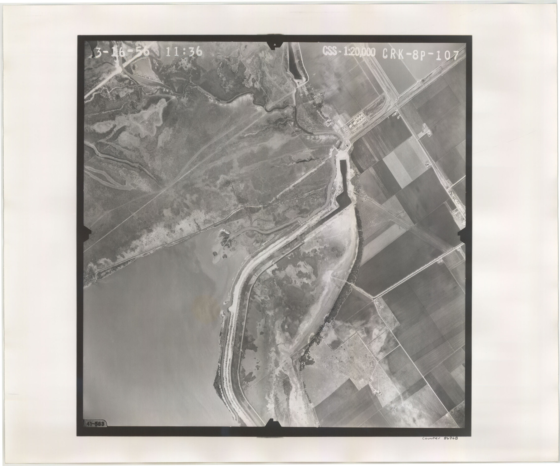
Flight Mission No. CRK-8P, Frame 107, Refugio County
CRK-8P-107
-
Map/Doc
86968
-
Collection
General Map Collection
-
Object Dates
1956/3/16 (Creation Date)
-
People and Organizations
U. S. Department of Agriculture (Publisher)
-
Counties
Refugio
-
Subjects
Aerial Photograph
-
Height x Width
18.4 x 22.0 inches
46.7 x 55.9 cm
-
Comments
Flown by V. L. Beavers and Associates of San Antonio, Texas.
Part of: General Map Collection
Current Miscellaneous File 86

Print $6.00
- Digital $50.00
Current Miscellaneous File 86
Size 11.2 x 8.8 inches
Map/Doc 74240
Archer County Sketch File 28-2

Print $40.00
- Digital $50.00
Archer County Sketch File 28-2
Size 21.4 x 16.9 inches
Map/Doc 10835
Webb County Sketch File 13-1

Print $6.00
- Digital $50.00
Webb County Sketch File 13-1
Size 8.5 x 7.8 inches
Map/Doc 39804
Dallas County Sketch File 2

Print $8.00
- Digital $50.00
Dallas County Sketch File 2
1855
Size 5.6 x 4.5 inches
Map/Doc 20396
Nueces County Rolled Sketch 98

Print $34.00
- Digital $50.00
Nueces County Rolled Sketch 98
1984
Size 24.5 x 36.4 inches
Map/Doc 7059
Dimmit County Sketch File 58

Print $20.00
- Digital $50.00
Dimmit County Sketch File 58
1951
Size 18.0 x 9.8 inches
Map/Doc 11361
Panola County Rolled Sketch 8

Print $20.00
- Digital $50.00
Panola County Rolled Sketch 8
1986
Size 20.1 x 18.0 inches
Map/Doc 7201
Harris County Sketch File AA3

Print $8.00
- Digital $50.00
Harris County Sketch File AA3
Size 8.2 x 8.5 inches
Map/Doc 25326
Flight Mission No. BRA-16M, Frame 142, Jefferson County

Print $20.00
- Digital $50.00
Flight Mission No. BRA-16M, Frame 142, Jefferson County
1953
Size 18.5 x 22.2 inches
Map/Doc 85748
Maps of Gulf Intracoastal Waterway, Texas - Sabine River to the Rio Grande and connecting waterways including ship channels

Print $20.00
- Digital $50.00
Maps of Gulf Intracoastal Waterway, Texas - Sabine River to the Rio Grande and connecting waterways including ship channels
1966
Size 14.5 x 22.2 inches
Map/Doc 61963
Flight Mission No. BRE-1P, Frame 50, Nueces County

Print $20.00
- Digital $50.00
Flight Mission No. BRE-1P, Frame 50, Nueces County
1956
Size 18.5 x 22.3 inches
Map/Doc 86639
Bandera County Working Sketch 12

Print $20.00
- Digital $50.00
Bandera County Working Sketch 12
Size 34.0 x 36.9 inches
Map/Doc 67605
You may also like

[Sketch showing Blocks B-11, O-18, P and Mc in case of Laneer vs. Bivens]
![91727, [Sketch showing Blocks B-11, O-18, P and Mc in case of Laneer vs. Bivens], Twichell Survey Records](https://historictexasmaps.com/wmedia_w700/maps/91727-1.tif.jpg)
Print $20.00
- Digital $50.00
[Sketch showing Blocks B-11, O-18, P and Mc in case of Laneer vs. Bivens]
Size 20.9 x 18.9 inches
Map/Doc 91727
Field Notes of Surveys in Travis District (Callahan, Coleman, and Runnels Counties)

Field Notes of Surveys in Travis District (Callahan, Coleman, and Runnels Counties)
Map/Doc 81675
Eberstadt and Brock's Subdivisions of the West Half of Survey Number 187 Block 2 A. B. & M., Randall County Texas

Print $20.00
- Digital $50.00
Eberstadt and Brock's Subdivisions of the West Half of Survey Number 187 Block 2 A. B. & M., Randall County Texas
Size 14.9 x 30.7 inches
Map/Doc 91747
Cameron County Rolled Sketch 25

Print $40.00
- Digital $50.00
Cameron County Rolled Sketch 25
1977
Size 25.0 x 72.9 inches
Map/Doc 5791
[Subdivision of Crockett County School Land Lgs. 214-217]
![90108, [Subdivision of Crockett County School Land Lgs. 214-217], Twichell Survey Records](https://historictexasmaps.com/wmedia_w700/maps/90108-1.tif.jpg)
Print $2.00
- Digital $50.00
[Subdivision of Crockett County School Land Lgs. 214-217]
Size 12.1 x 8.3 inches
Map/Doc 90108
Dallas County Sketch File 16

Print $4.00
- Digital $50.00
Dallas County Sketch File 16
Size 8.0 x 8.4 inches
Map/Doc 20435
Montgomery County, Texas

Print $20.00
- Digital $50.00
Montgomery County, Texas
1880
Size 24.6 x 27.6 inches
Map/Doc 582
Flight Mission No. DAG-21K, Frame 31, Matagorda County

Print $20.00
- Digital $50.00
Flight Mission No. DAG-21K, Frame 31, Matagorda County
1952
Size 18.7 x 22.4 inches
Map/Doc 86398
Harris County Historic Topographic 20

Print $20.00
- Digital $50.00
Harris County Historic Topographic 20
1915
Size 29.3 x 22.6 inches
Map/Doc 65831
Map of South Eastern Washington Territory

Print $20.00
Map of South Eastern Washington Territory
1878
Size 31.3 x 41.1 inches
Map/Doc 93942
Fractional Township No. 10 South Range No. 27 East of the Indian Meridian, Indian Territory

Print $20.00
- Digital $50.00
Fractional Township No. 10 South Range No. 27 East of the Indian Meridian, Indian Territory
1897
Size 19.2 x 24.3 inches
Map/Doc 75246