Cameron County Rolled Sketch 25
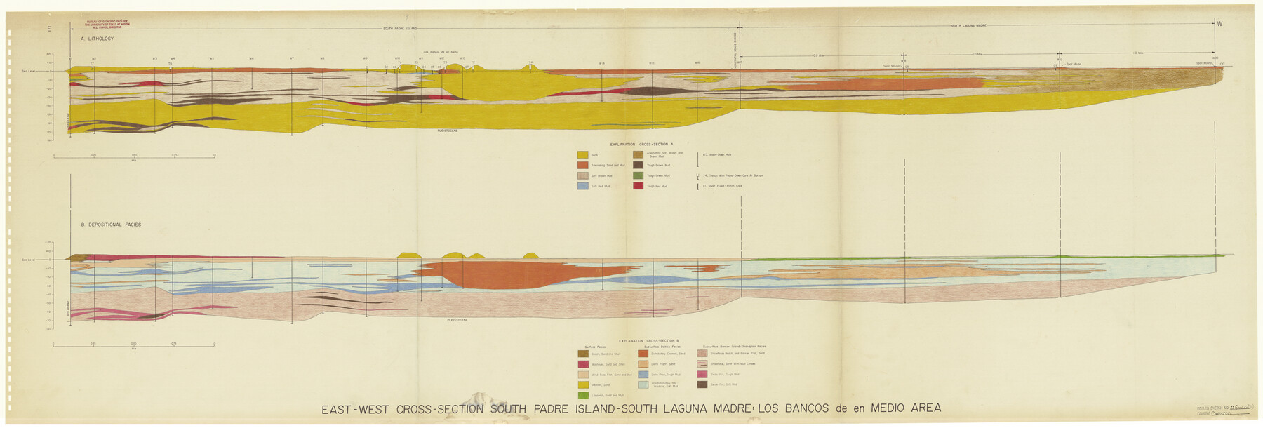
East-West Cross-section South Padre Island-South Laguna Madre: Los Bancos de en Medio Area [Page 2 of 10]
-
Map/Doc
5791
-
Collection
General Map Collection
-
Object Dates
1977 (Creation Date)
12/6/1983 (File Date)
-
People and Organizations
Bureau of Economic Geology, University of Texas (Publisher)
W.L. Fisher (Author)
-
Counties
Cameron
-
Subjects
Surveying Rolled Sketch
-
Height x Width
25.0 x 72.9 inches
63.5 x 185.2 cm
-
Medium
paper, etching/engraving/lithograph
-
Comments
See maps 5790-5799 for all sheets in this set.
Related maps
Cameron County Rolled Sketch 25

Print $20.00
- Digital $50.00
Cameron County Rolled Sketch 25
1977
Size 17.5 x 27.5 inches
Map/Doc 5790
Cameron County Rolled Sketch 25

Print $20.00
- Digital $50.00
Cameron County Rolled Sketch 25
1977
Size 24.8 x 36.8 inches
Map/Doc 5792
Cameron County Rolled Sketch 25

Print $20.00
- Digital $50.00
Cameron County Rolled Sketch 25
1977
Size 24.5 x 30.4 inches
Map/Doc 5793
Cameron County Rolled Sketch 25

Print $20.00
- Digital $50.00
Cameron County Rolled Sketch 25
1977
Size 24.9 x 36.7 inches
Map/Doc 5794
Cameron County Rolled Sketch 25

Print $20.00
- Digital $50.00
Cameron County Rolled Sketch 25
1977
Size 24.7 x 36.7 inches
Map/Doc 5795
Cameron County Rolled Sketch 25

Print $20.00
- Digital $50.00
Cameron County Rolled Sketch 25
1977
Size 24.6 x 36.7 inches
Map/Doc 5796
Cameron County Rolled Sketch 25

Print $20.00
- Digital $50.00
Cameron County Rolled Sketch 25
1977
Size 24.8 x 36.5 inches
Map/Doc 5797
Cameron County Rolled Sketch 25

Print $20.00
- Digital $50.00
Cameron County Rolled Sketch 25
1977
Size 24.8 x 36.6 inches
Map/Doc 5798
Cameron County Rolled Sketch 25

Print $20.00
- Digital $50.00
Cameron County Rolled Sketch 25
1977
Size 24.9 x 36.7 inches
Map/Doc 5799
Part of: General Map Collection
Liberty County Sketch File 45

Print $4.00
- Digital $50.00
Liberty County Sketch File 45
Size 7.8 x 10.1 inches
Map/Doc 30003
Harris County Sketch File 68

Print $20.00
- Digital $50.00
Harris County Sketch File 68
1939
Size 22.9 x 10.6 inches
Map/Doc 11662
Goliad Station Map, Galveston, Harrisburg & San Antonio Ry. operated by the T. & N. O. R.R. Co.

Print $40.00
- Digital $50.00
Goliad Station Map, Galveston, Harrisburg & San Antonio Ry. operated by the T. & N. O. R.R. Co.
1918
Size 24.7 x 55.8 inches
Map/Doc 76161
Intracoastal Waterway in Texas - Corpus Christi to Point Isabel including Arroyo Colorado to Mo. Pac. R.R. Bridge Near Harlingen

Print $20.00
- Digital $50.00
Intracoastal Waterway in Texas - Corpus Christi to Point Isabel including Arroyo Colorado to Mo. Pac. R.R. Bridge Near Harlingen
1934
Size 21.8 x 32.6 inches
Map/Doc 61888
Flight Mission No. CLL-1N, Frame 35, Willacy County

Print $20.00
- Digital $50.00
Flight Mission No. CLL-1N, Frame 35, Willacy County
1954
Size 18.5 x 22.1 inches
Map/Doc 87016
Sterling County Rolled Sketch 23A

Print $131.00
- Digital $50.00
Sterling County Rolled Sketch 23A
Size 10.6 x 15.2 inches
Map/Doc 49032
Hays County Sketch File 16a

Print $4.00
- Digital $50.00
Hays County Sketch File 16a
1871
Size 8.2 x 9.7 inches
Map/Doc 26229
Anderson County Working Sketch 46

Print $20.00
- Digital $50.00
Anderson County Working Sketch 46
2000
Size 29.2 x 34.2 inches
Map/Doc 67046
Township 3 North Range 14 West, North Western District, Louisiana

Print $20.00
- Digital $50.00
Township 3 North Range 14 West, North Western District, Louisiana
1844
Size 19.8 x 24.7 inches
Map/Doc 65862
Station Map, the Missouri, Kansas and Texas Ry. Of Texas - Henrietta Division

Print $20.00
- Digital $50.00
Station Map, the Missouri, Kansas and Texas Ry. Of Texas - Henrietta Division
1918
Size 11.8 x 26.7 inches
Map/Doc 64763
Padre Island National Seashore, Texas - Dependent Resurvey

Print $4.00
- Digital $50.00
Padre Island National Seashore, Texas - Dependent Resurvey
2001
Size 18.3 x 24.4 inches
Map/Doc 60545
[Drawings of individual counties for Pressler and Langermann's 1879 Map of Texas]
![[Drawings of individual counties for Pressler and Langermann's 1879 Map of Texas]](https://historictexasmaps.com/wmedia_w700/maps/4863.tif.jpg)
Print $20.00
- Digital $50.00
[Drawings of individual counties for Pressler and Langermann's 1879 Map of Texas]
1878
Size 38.8 x 26.8 inches
Map/Doc 4863
You may also like
Loving County Rolled Sketch 19

Print $20.00
- Digital $50.00
Loving County Rolled Sketch 19
2020
Size 24.4 x 35.3 inches
Map/Doc 96575
Baylor County Rolled Sketch 8

Print $20.00
- Digital $50.00
Baylor County Rolled Sketch 8
1883
Size 12.9 x 18.4 inches
Map/Doc 5124
Cottle County Rolled Sketch 13

Print $20.00
- Digital $50.00
Cottle County Rolled Sketch 13
1976
Size 21.6 x 35.5 inches
Map/Doc 5571
County and Railroad Map of Texas

Print $20.00
- Digital $50.00
County and Railroad Map of Texas
1875
Size 17.4 x 16.0 inches
Map/Doc 95754
Galveston County NRC Article 33.136 Sketch 73

Print $28.00
- Digital $50.00
Galveston County NRC Article 33.136 Sketch 73
2013
Size 31.7 x 24.0 inches
Map/Doc 94995
Flight Mission No. BRA-6M, Frame 79, Jefferson County

Print $20.00
- Digital $50.00
Flight Mission No. BRA-6M, Frame 79, Jefferson County
1953
Size 18.6 x 22.4 inches
Map/Doc 85423
Hudspeth County Sketch File 44

Print $6.00
- Digital $50.00
Hudspeth County Sketch File 44
1886
Size 11.0 x 8.5 inches
Map/Doc 27027
Hill County Working Sketch 4

Print $20.00
- Digital $50.00
Hill County Working Sketch 4
1982
Size 25.3 x 23.3 inches
Map/Doc 66190
The Republic County of Travis. Created, January 25, 1840

Print $20.00
The Republic County of Travis. Created, January 25, 1840
2020
Size 20.8 x 21.6 inches
Map/Doc 96289
Geological Map of the route explored by Capt. Jno. Pope, Corps of Topl. Engrs. near the 32nd Parallel of North Latitude from the Red River to the Rio Grande

Print $20.00
- Digital $50.00
Geological Map of the route explored by Capt. Jno. Pope, Corps of Topl. Engrs. near the 32nd Parallel of North Latitude from the Red River to the Rio Grande
1854
Size 11.1 x 24.8 inches
Map/Doc 95751
Pecos County Rolled Sketch 143

Print $74.00
- Digital $50.00
Pecos County Rolled Sketch 143
1935
Size 14.8 x 9.4 inches
Map/Doc 48359
Angelina County Working Sketch 31

Print $20.00
- Digital $50.00
Angelina County Working Sketch 31
1955
Size 24.3 x 24.5 inches
Map/Doc 67113