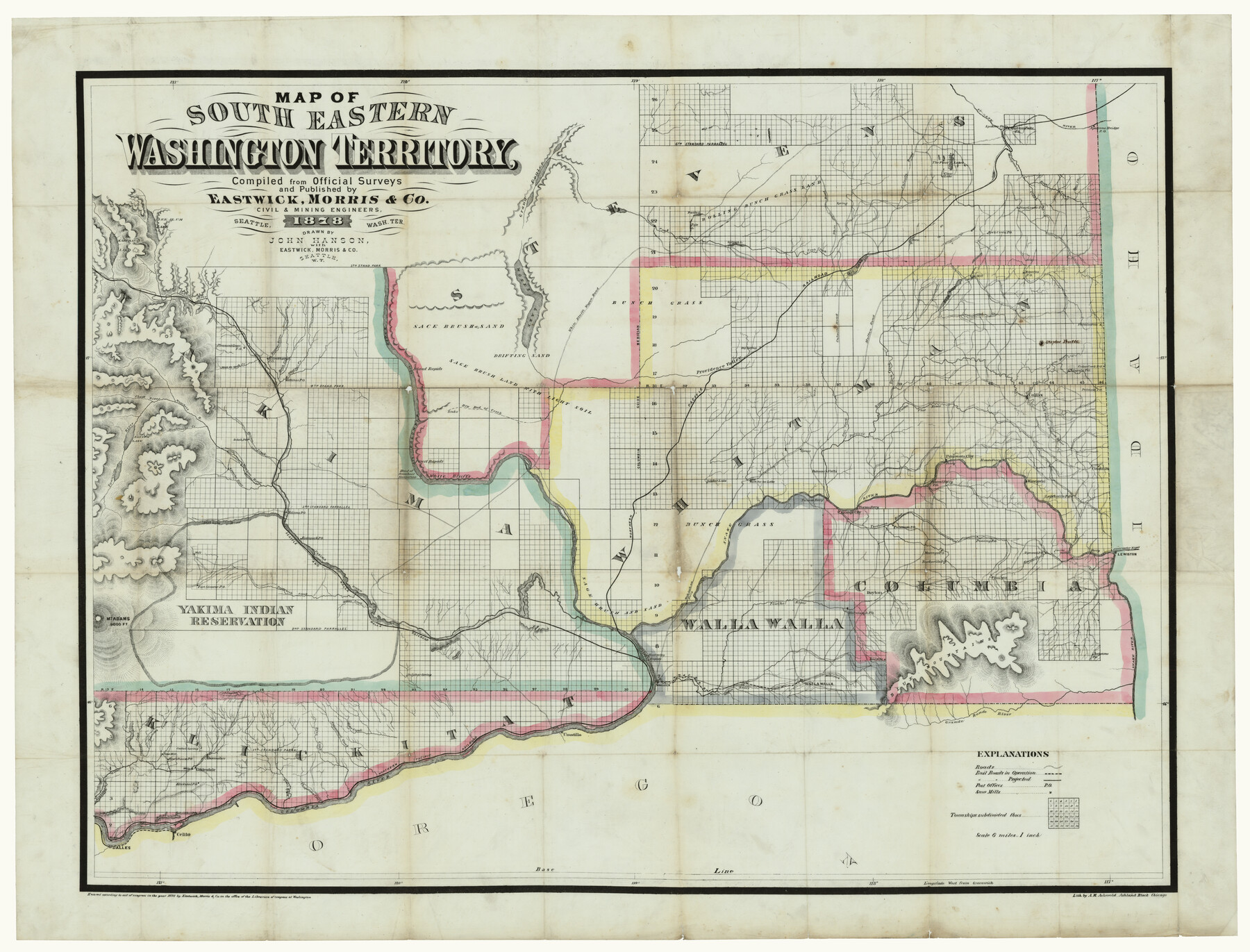
Map of South Eastern Washington Territory
-
Map/Doc
93942
-
Collection
Non-GLO Digital Images
-
Object Dates
1878 (Creation Date)
-
People and Organizations
Eastwick, Morris & Co. (Publisher)
Eastwick, Morris & Co. (Compiler)
John Hanson (Draftsman)
-
Height x Width
31.3 x 41.1 inches
79.5 x 104.4 cm
-
Comments
Courtesy of Patrick "Rick" Stewart of Fort Worth, TX
Part of: Non-GLO Digital Images
Map of Texas and part of New Mexico

Print $20.00
Map of Texas and part of New Mexico
1857
Size 17.4 x 23.1 inches
Map/Doc 95284
Ladonia, Fannin County, Texas

Print $20.00
Ladonia, Fannin County, Texas
1891
Size 12.0 x 22.1 inches
Map/Doc 89097

Mexico, California and Texas

Print $20.00
Mexico, California and Texas
1850
Size 11.1 x 15.0 inches
Map/Doc 82964
Bird's Eye View of the City of Brenham, Washington County, Texas

Print $20.00
Bird's Eye View of the City of Brenham, Washington County, Texas
1881
Size 19.4 x 26.7 inches
Map/Doc 89076
Map of the United States Exhibiting the grants of lands made by the general government to aid in the construction of railroads and wagon roads

Print $20.00
Map of the United States Exhibiting the grants of lands made by the general government to aid in the construction of railroads and wagon roads
1878
Size 20.8 x 29.4 inches
Map/Doc 95286
A Map of the United States of Mexico as organized and defined by the several Acts of the Congress of that Republic

Print $20.00
A Map of the United States of Mexico as organized and defined by the several Acts of the Congress of that Republic
1826
Size 23.2 x 28.9 inches
Map/Doc 93635
Bird's Eye View of Schulenburg, Fayette County, Texas

Print $20.00
Bird's Eye View of Schulenburg, Fayette County, Texas
1881
Size 18.6 x 31.0 inches
Map/Doc 89206
[Movements & Objectives of the 143rd & 144th Infantry and many other divisions and regiments, 1918]
![94138, [Movements & Objectives of the 143rd & 144th Infantry and many other divisions and regiments, 1918], Non-GLO Digital Images](https://historictexasmaps.com/wmedia_w700/maps/94138-1.tif.jpg)
Print $40.00
[Movements & Objectives of the 143rd & 144th Infantry and many other divisions and regiments, 1918]
1918
Size 64.2 x 37.5 inches
Map/Doc 94138

Waco, Tex., County Seat of McLennan Co.

Print $20.00
Waco, Tex., County Seat of McLennan Co.
1886
Size 23.1 x 32.7 inches
Map/Doc 89212
[Stephen F. Austin's Map of Texas]
![95825, [Stephen F. Austin's Map of Texas], Non-GLO Digital Images](https://historictexasmaps.com/wmedia_w700/maps/95825.tif.jpg)
[Stephen F. Austin's Map of Texas]
1829
Size 21.7 x 17.9 inches
Map/Doc 95825
You may also like
Amerique Septentrionale

Print $20.00
- Digital $50.00
Amerique Septentrionale
1650
Size 17.2 x 23.1 inches
Map/Doc 93684
General Highway Map, Hockley County, Texas

Print $20.00
General Highway Map, Hockley County, Texas
1961
Size 18.2 x 24.6 inches
Map/Doc 79522
Karte von Texas entworfen nach den Vermessungen, welche in den Acten der General-Land-Office der Republic liegen bis zum Jahr 1839 von Richard S. Hunt & Jesse F. Randel

Print $20.00
Karte von Texas entworfen nach den Vermessungen, welche in den Acten der General-Land-Office der Republic liegen bis zum Jahr 1839 von Richard S. Hunt & Jesse F. Randel
1841
Size 19.6 x 14.6 inches
Map/Doc 79311
Post City and Surroundings Showing Improvements and 4 Sec. Pastures

Print $20.00
- Digital $50.00
Post City and Surroundings Showing Improvements and 4 Sec. Pastures
1911
Size 36.4 x 29.8 inches
Map/Doc 90858
Flight Mission No. BRE-1P, Frame 143, Nueces County

Print $20.00
- Digital $50.00
Flight Mission No. BRE-1P, Frame 143, Nueces County
1956
Size 18.3 x 22.2 inches
Map/Doc 86703
Brazos River Conservation and Reclamation District Official Boundary Line Survey, Parmer County

Print $20.00
- Digital $50.00
Brazos River Conservation and Reclamation District Official Boundary Line Survey, Parmer County
Size 24.5 x 16.9 inches
Map/Doc 91658
DeWitt County Sketch File 13

Print $8.00
- Digital $50.00
DeWitt County Sketch File 13
1845
Size 12.8 x 8.2 inches
Map/Doc 20824
Presidio County Sketch File 69b

Print $6.00
- Digital $50.00
Presidio County Sketch File 69b
1919
Size 11.2 x 8.8 inches
Map/Doc 34666
Liberty County Sketch File 13

Print $12.00
- Digital $50.00
Liberty County Sketch File 13
1858
Size 8.3 x 7.9 inches
Map/Doc 29909
Bowie County Working Sketch Graphic Index

Print $20.00
- Digital $50.00
Bowie County Working Sketch Graphic Index
1933
Size 38.9 x 47.1 inches
Map/Doc 76470
Aransas County Sketch File 28

Print $16.00
- Digital $50.00
Aransas County Sketch File 28
1973
Size 11.3 x 8.8 inches
Map/Doc 13226
Dickens County Rolled Sketch H

Print $20.00
- Digital $50.00
Dickens County Rolled Sketch H
1902
Size 26.4 x 19.1 inches
Map/Doc 5712