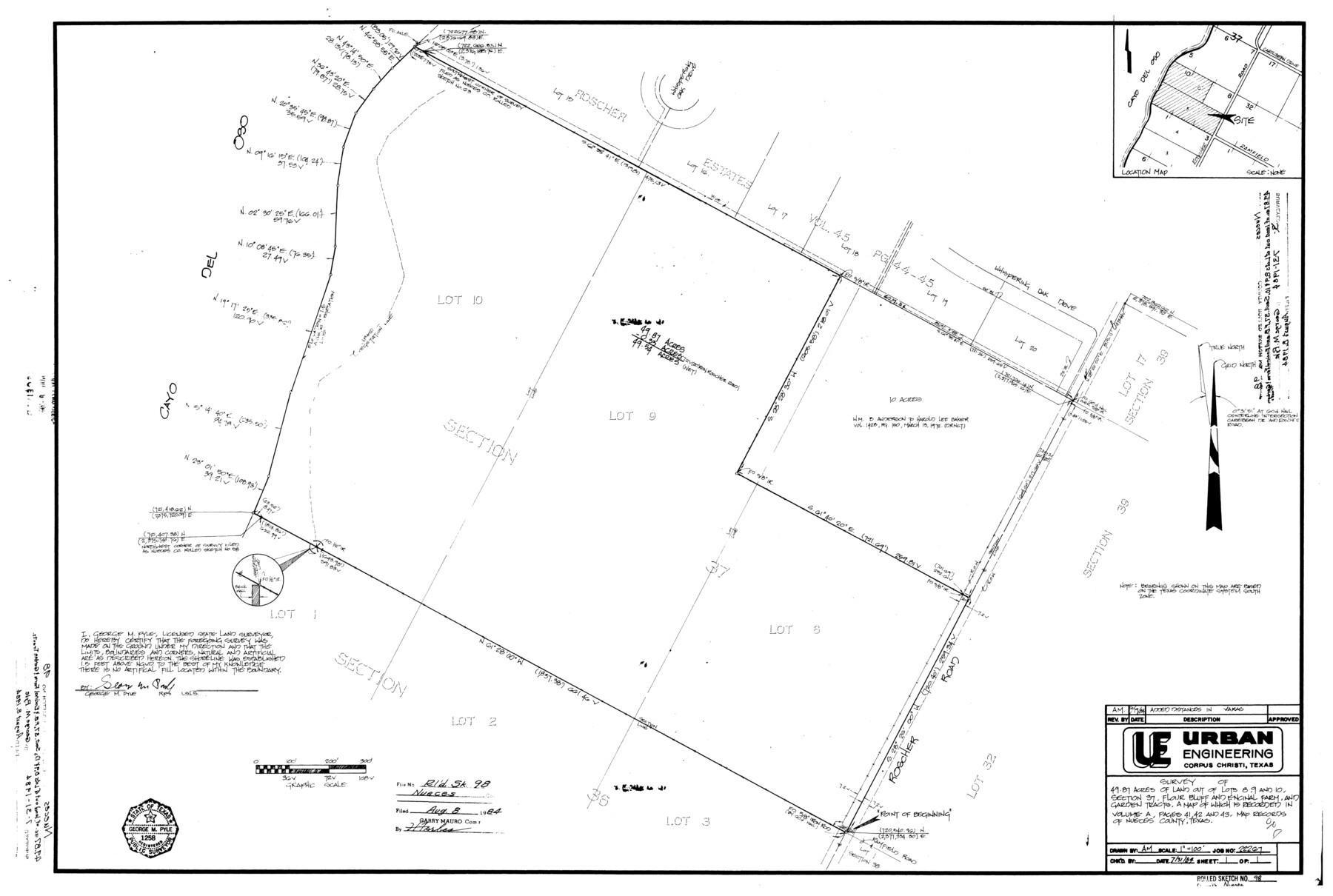
Nueces County Rolled Sketch 98
[Plats and correspondence relating to] survey of 49.87 acres of land out of lots 8, 9, and 10, section 37, Flour Bluff and Encinal Farm and Garden Tracts
-
Map/Doc
7059
-
Collection
General Map Collection
-
Object Dates
1984/7/31 (Creation Date)
1984/8/31 (File Date)
-
People and Organizations
George M. Pyle (Surveyor/Engineer)
-
Counties
Nueces
-
Subjects
Surveying Rolled Sketch
-
Height x Width
24.5 x 36.4 inches
62.2 x 92.5 cm
-
Medium
multi-page, multi-format
-
Scale
1" = 100 feet
-
Comments
See Nueces County Rolled Sketch 98B (9632) for aerial photograph of this area.
Related maps
Nueces County Rolled Sketch 98B

Print $20.00
- Digital $50.00
Nueces County Rolled Sketch 98B
Size 33.5 x 32.7 inches
Map/Doc 9632
Part of: General Map Collection
Nolan County Rolled Sketch 4

Print $20.00
- Digital $50.00
Nolan County Rolled Sketch 4
1982
Size 21.7 x 25.2 inches
Map/Doc 6862
Map showing survey for proposed ship channel from Brownsville to Brazos Santiago Pass

Print $20.00
- Digital $50.00
Map showing survey for proposed ship channel from Brownsville to Brazos Santiago Pass
1912
Size 18.2 x 26.9 inches
Map/Doc 72898
Morris County Rolled Sketch 2A

Print $20.00
- Digital $50.00
Morris County Rolled Sketch 2A
Size 22.7 x 17.7 inches
Map/Doc 10227
Pecos County Working Sketch 68

Print $20.00
- Digital $50.00
Pecos County Working Sketch 68
1955
Size 41.4 x 24.0 inches
Map/Doc 71540
Bexar County Sketch File 58

Print $4.00
- Digital $50.00
Bexar County Sketch File 58
1847
Size 10.4 x 8.3 inches
Map/Doc 14572
Midland County Sketch File 3

Print $20.00
- Digital $50.00
Midland County Sketch File 3
1886
Size 18.3 x 25.2 inches
Map/Doc 12081
Gulf Intracoastal Waterway - Aransas Bay to Corpus Christi Bay, Modified Route of Main Channel Location of Spoil Disposal Areas

Print $20.00
- Digital $50.00
Gulf Intracoastal Waterway - Aransas Bay to Corpus Christi Bay, Modified Route of Main Channel Location of Spoil Disposal Areas
1961
Size 31.4 x 42.1 inches
Map/Doc 61829
La Salle County Sketch File 48

Print $6.00
- Digital $50.00
La Salle County Sketch File 48
1942
Size 11.2 x 8.8 inches
Map/Doc 29617
[Aransas County, Texas]
![2083, [Aransas County, Texas], General Map Collection](https://historictexasmaps.com/wmedia_w700/maps/2083.tif.jpg)
Print $20.00
- Digital $50.00
[Aransas County, Texas]
1928
Size 37.5 x 31.3 inches
Map/Doc 2083
Webb County Working Sketch 60

Print $20.00
- Digital $50.00
Webb County Working Sketch 60
1960
Size 43.3 x 47.8 inches
Map/Doc 72426
[Right of Way & Track Map, The Texas & Pacific Ry. Co. Main Line]
![64684, [Right of Way & Track Map, The Texas & Pacific Ry. Co. Main Line], General Map Collection](https://historictexasmaps.com/wmedia_w700/maps/64684.tif.jpg)
Print $20.00
- Digital $50.00
[Right of Way & Track Map, The Texas & Pacific Ry. Co. Main Line]
Size 11.0 x 19.0 inches
Map/Doc 64684
Potter County Sketch File 17

Print $16.00
- Digital $50.00
Potter County Sketch File 17
1920
Size 11.2 x 8.7 inches
Map/Doc 34403
You may also like
Crockett County Rolled Sketch 58

Print $20.00
- Digital $50.00
Crockett County Rolled Sketch 58
Size 19.0 x 32.8 inches
Map/Doc 5600
City of Andrews

Print $20.00
- Digital $50.00
City of Andrews
1951
Size 25.1 x 24.2 inches
Map/Doc 92454
Ochiltree County State of Texas

Print $20.00
- Digital $50.00
Ochiltree County State of Texas
1889
Size 25.5 x 19.0 inches
Map/Doc 4609
State of Texas

Print $40.00
- Digital $50.00
State of Texas
1985
Size 50.0 x 53.6 inches
Map/Doc 2486
Travis County Sketch File 9

Print $4.00
- Digital $50.00
Travis County Sketch File 9
Size 12.6 x 8.2 inches
Map/Doc 38290
Smith County Working Sketch 2

Print $20.00
- Digital $50.00
Smith County Working Sketch 2
Size 16.3 x 13.1 inches
Map/Doc 63887
Plan de la Villa de Austin

Print $20.00
- Digital $50.00
Plan de la Villa de Austin
1828
Size 18.5 x 12.5 inches
Map/Doc 94116
General Highway Map, Wichita County, Texas

Print $20.00
General Highway Map, Wichita County, Texas
1940
Size 18.1 x 24.8 inches
Map/Doc 79277
Coke County Working Sketch 11

Print $20.00
- Digital $50.00
Coke County Working Sketch 11
1945
Size 40.9 x 40.2 inches
Map/Doc 68048
Presidio County Rolled Sketch 86

Print $20.00
- Digital $50.00
Presidio County Rolled Sketch 86
1945
Size 34.1 x 27.8 inches
Map/Doc 7372
Calhoun County Sketch File 14

Print $20.00
- Digital $50.00
Calhoun County Sketch File 14
1852
Size 22.6 x 16.2 inches
Map/Doc 35980
Current Miscellaneous File 31

Print $8.00
- Digital $50.00
Current Miscellaneous File 31
1916
Size 11.2 x 8.7 inches
Map/Doc 73929