Panola County Rolled Sketch 8
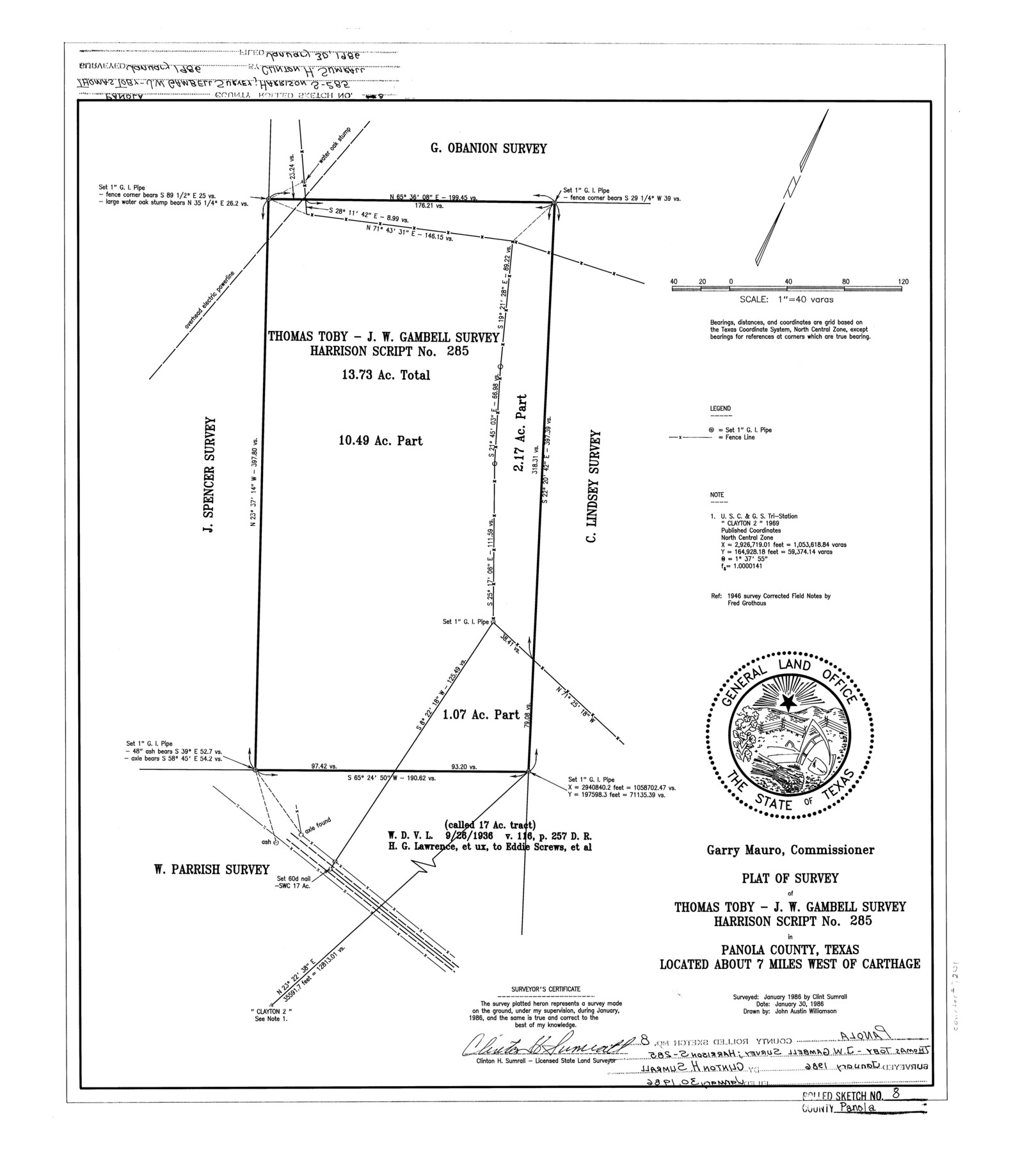
Plat of survey of Thomas Toby - J.W. Gambell survey, Harrison Script no. 285 in Panola County, Texas
-
Map/Doc
7201
-
Collection
General Map Collection
-
Object Dates
1986/1/30 (Creation Date)
1986/1/30 (File Date)
-
People and Organizations
Clinton H. Sumrall (Surveyor/Engineer)
John Austin Williamson (Draftsman)
-
Counties
Panola
-
Subjects
Surveying Rolled Sketch
-
Height x Width
20.1 x 18.0 inches
51.1 x 45.7 cm
-
Medium
mylar, print
-
Scale
1" = 40 varas
Part of: General Map Collection

Montgomery County Rolled Sketch 18

Print $40.00
- Digital $50.00
Montgomery County Rolled Sketch 18
Size 51.4 x 25.3 inches
Map/Doc 9528
Jefferson County Sketch File 54

Print $226.00
- Digital $50.00
Jefferson County Sketch File 54
1961
Size 11.0 x 8.5 inches
Map/Doc 28359
Lamar County Sketch File 11

Print $24.00
- Digital $50.00
Lamar County Sketch File 11
1934
Size 11.5 x 7.2 inches
Map/Doc 29295
Rusk County Sketch File 11

Print $4.00
Rusk County Sketch File 11
1849
Size 8.5 x 9.1 inches
Map/Doc 35509
Map of Texas in 1830 Showing Spanish Colonies

Print $20.00
- Digital $50.00
Map of Texas in 1830 Showing Spanish Colonies
Size 41.1 x 42.0 inches
Map/Doc 73588
Fractional Township No. 10 South Range No. 24 East of the Indian Meridian, Indian Territory

Print $20.00
- Digital $50.00
Fractional Township No. 10 South Range No. 24 East of the Indian Meridian, Indian Territory
1898
Size 19.1 x 24.2 inches
Map/Doc 75242
Brazos River, Harlem-Imperial Farms Project

Print $20.00
- Digital $50.00
Brazos River, Harlem-Imperial Farms Project
1930
Size 28.3 x 25.5 inches
Map/Doc 69678

Presidio County Rolled Sketch 89

Print $20.00
- Digital $50.00
Presidio County Rolled Sketch 89
1946
Size 34.4 x 25.5 inches
Map/Doc 7374
El Paso County

Print $40.00
- Digital $50.00
El Paso County
1881
Size 53.7 x 88.3 inches
Map/Doc 16826
La Salle County Rolled Sketch 8

Print $20.00
- Digital $50.00
La Salle County Rolled Sketch 8
Size 21.4 x 43.9 inches
Map/Doc 6571
You may also like
Andrews County Working Sketch 13

Print $20.00
- Digital $50.00
Andrews County Working Sketch 13
1956
Size 37.3 x 30.6 inches
Map/Doc 67059
Milam County Working Sketch 12

Print $40.00
- Digital $50.00
Milam County Working Sketch 12
Size 44.3 x 56.4 inches
Map/Doc 71027
Menard County Boundary File 12a

Print $14.00
- Digital $50.00
Menard County Boundary File 12a
Size 14.2 x 8.8 inches
Map/Doc 57114
Haskell County Sketch File 20

Print $20.00
- Digital $50.00
Haskell County Sketch File 20
1902
Size 20.9 x 26.2 inches
Map/Doc 11743
Terrell County Sketch File 29

Print $6.00
- Digital $50.00
Terrell County Sketch File 29
1940
Size 11.2 x 8.8 inches
Map/Doc 37976
Wichita County Sketch File 7

Print $2.00
- Digital $50.00
Wichita County Sketch File 7
Size 7.5 x 13.9 inches
Map/Doc 40047
Galveston County NRC Article 33.136 Sketch 93

Digital $50.00
Galveston County NRC Article 33.136 Sketch 93
2020
Map/Doc 97257
Harris County Rolled Sketch 44

Print $20.00
- Digital $50.00
Harris County Rolled Sketch 44
Size 22.5 x 29.9 inches
Map/Doc 6102
Gulf Coast of the United States, Key West to Rio Grande

Print $20.00
- Digital $50.00
Gulf Coast of the United States, Key West to Rio Grande
1863
Size 18.4 x 27.2 inches
Map/Doc 72668
Chambers County Sketch File 21a

Print $2.00
- Digital $50.00
Chambers County Sketch File 21a
1867
Size 10.2 x 6.6 inches
Map/Doc 17593
[R. M. Thompson, Block A]
![91129, [R. M. Thompson, Block A], Twichell Survey Records](https://historictexasmaps.com/wmedia_w700/maps/91129-1.tif.jpg)
Print $3.00
- Digital $50.00
[R. M. Thompson, Block A]
Size 9.6 x 11.8 inches
Map/Doc 91129
Flight Mission No. CLL-1N, Frame 84, Willacy County

Print $20.00
- Digital $50.00
Flight Mission No. CLL-1N, Frame 84, Willacy County
1954
Size 18.5 x 22.2 inches
Map/Doc 87030