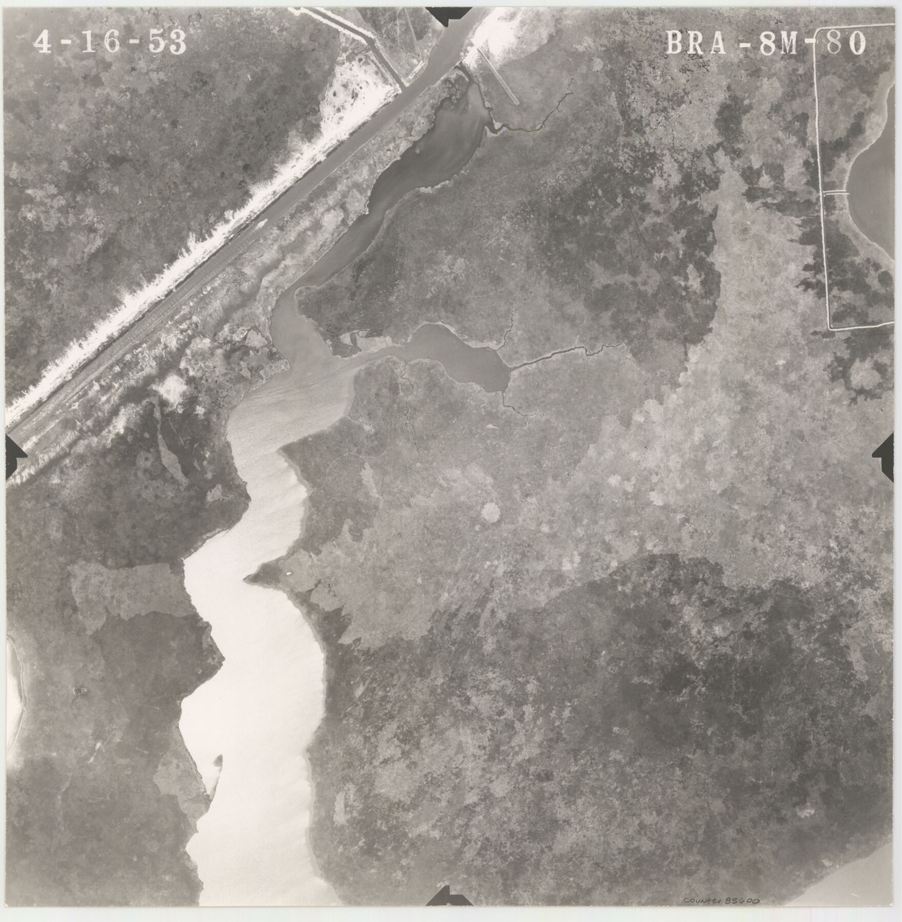
Flight Mission No. BRA-8M, Frame 80, Jefferson County
[Aerial Photo, Jefferson County, frame BRA-8M-80]
-
Map/Doc
85600
-
Collection
General Map Collection
-
Object Dates
1953/4/16 (Creation Date)
-
People and Organizations
U. S. Department of Agriculture (Publisher)
-
Counties
Jefferson
-
Subjects
Aerial Photograph
-
Height x Width
15.9 x 15.6 inches
40.4 x 39.6 cm
-
Comments
Flown by Jack Ammann Photogrammetric Engineers of San Antonio, Texas.
Part of: General Map Collection
Flight Mission No. BRA-16M, Frame 138, Jefferson County

Print $20.00
- Digital $50.00
Flight Mission No. BRA-16M, Frame 138, Jefferson County
1953
Size 18.7 x 22.3 inches
Map/Doc 85744
Edwards County Sketch File 35

Print $4.00
- Digital $50.00
Edwards County Sketch File 35
Size 11.3 x 8.9 inches
Map/Doc 21769
Kerr County Sketch File 17

Print $20.00
- Digital $50.00
Kerr County Sketch File 17
1950
Size 23.3 x 23.8 inches
Map/Doc 11920
Hardeman County Sketch File 14

Print $8.00
- Digital $50.00
Hardeman County Sketch File 14
1884
Size 12.7 x 8.1 inches
Map/Doc 25022
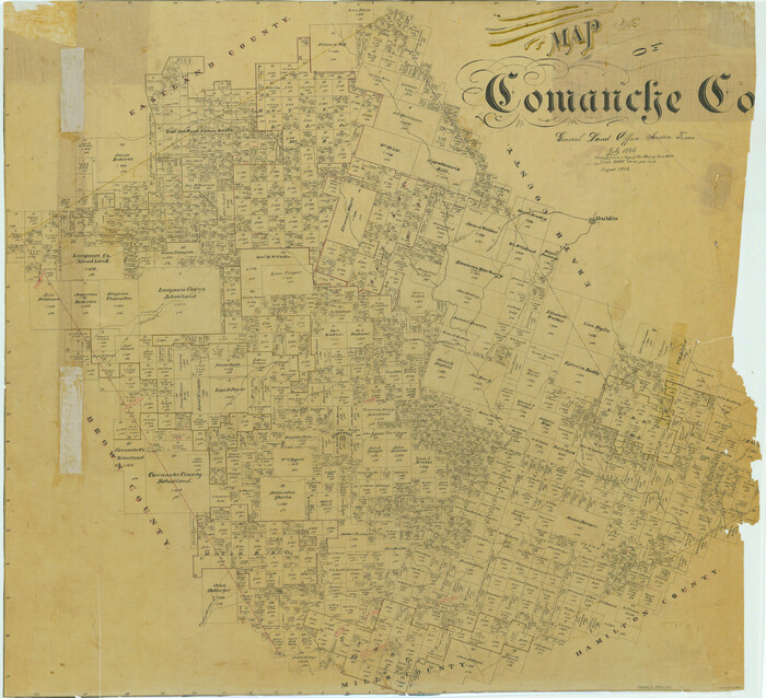
Map of Comanche Co.
Print $20.00
- Digital $50.00
Map of Comanche Co.
1896
Size 39.3 x 43.1 inches
Map/Doc 66782
General Road Map, Webb County, Texas

Print $40.00
- Digital $50.00
General Road Map, Webb County, Texas
1944
Size 37.1 x 50.0 inches
Map/Doc 10126
Flight Mission No. BQR-5K, Frame 71, Brazoria County

Print $20.00
- Digital $50.00
Flight Mission No. BQR-5K, Frame 71, Brazoria County
1952
Size 18.8 x 22.4 inches
Map/Doc 84016
Fannin County Boundary File 1

Print $14.00
- Digital $50.00
Fannin County Boundary File 1
Size 13.2 x 8.6 inches
Map/Doc 53272
[San Patricio No. 2]
![69746, [San Patricio No. 2], General Map Collection](https://historictexasmaps.com/wmedia_w700/maps/69746.tif.jpg)
Print $2.00
- Digital $50.00
[San Patricio No. 2]
1847
Size 8.3 x 11.2 inches
Map/Doc 69746
Controlled Mosaic by Jack Amman Photogrammetric Engineers, Inc - Sheet 48

Print $20.00
- Digital $50.00
Controlled Mosaic by Jack Amman Photogrammetric Engineers, Inc - Sheet 48
1954
Size 20.0 x 24.0 inches
Map/Doc 83507
Map of Henderson County

Print $20.00
- Digital $50.00
Map of Henderson County
1877
Size 17.7 x 29.2 inches
Map/Doc 3666
Flight Mission No. CGI-3N, Frame 50, Cameron County

Print $20.00
- Digital $50.00
Flight Mission No. CGI-3N, Frame 50, Cameron County
1954
Size 18.6 x 22.2 inches
Map/Doc 84556
You may also like
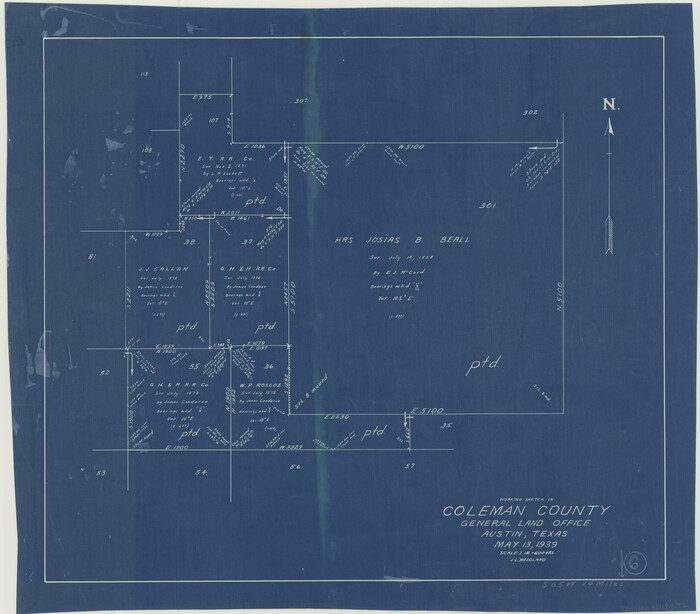
Coleman County Working Sketch 6
Print $20.00
- Digital $50.00
Coleman County Working Sketch 6
1939
Size 19.1 x 21.8 inches
Map/Doc 68072
Newton County Working Sketch 1

Print $20.00
- Digital $50.00
Newton County Working Sketch 1
Size 25.5 x 25.9 inches
Map/Doc 71247
[Jack District]
![1992, [Jack District], General Map Collection](https://historictexasmaps.com/wmedia_w700/maps/1992.tif.jpg)
Print $40.00
- Digital $50.00
[Jack District]
1880
Size 52.7 x 43.4 inches
Map/Doc 1992
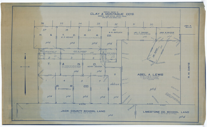
Montague County Working Sketch 41
Print $40.00
- Digital $50.00
Montague County Working Sketch 41
1923
Size 43.3 x 70.1 inches
Map/Doc 65350
Crockett County Sketch File 77

Print $8.00
- Digital $50.00
Crockett County Sketch File 77
1932
Size 11.2 x 8.7 inches
Map/Doc 19877
[Sketch showing C. D. & W. A. Murphy's Pasture and Wint Barfield's Pasture]
![90935, [Sketch showing C. D. & W. A. Murphy's Pasture and Wint Barfield's Pasture], Twichell Survey Records](https://historictexasmaps.com/wmedia_w700/maps/90935-1.tif.jpg)
Print $20.00
- Digital $50.00
[Sketch showing C. D. & W. A. Murphy's Pasture and Wint Barfield's Pasture]
Size 30.4 x 26.7 inches
Map/Doc 90935
Frio County Rolled Sketch 12

Print $20.00
- Digital $50.00
Frio County Rolled Sketch 12
1948
Size 36.5 x 45.5 inches
Map/Doc 8904

Pecos County Rolled Sketch 185

Print $20.00
- Digital $50.00
Pecos County Rolled Sketch 185
1985
Size 34.9 x 29.0 inches
Map/Doc 7304
General Highway Map. Detail of Cities and Towns in Harris County, Texas. City Map [of] Houston, Pasadena, West University Place, Bellaire, Galena Park, Jacinto City, South Houston, South Side Place, Deer Park, and vicinity, Harris County, Texas
![79504, General Highway Map. Detail of Cities and Towns in Harris County, Texas. City Map [of] Houston, Pasadena, West University Place, Bellaire, Galena Park, Jacinto City, South Houston, South Side Place, Deer Park, and vicinity, Harris County, Texas, Texas State Library and Archives](https://historictexasmaps.com/wmedia_w700/maps/79504.tif.jpg)
Print $20.00
General Highway Map. Detail of Cities and Towns in Harris County, Texas. City Map [of] Houston, Pasadena, West University Place, Bellaire, Galena Park, Jacinto City, South Houston, South Side Place, Deer Park, and vicinity, Harris County, Texas
1961
Size 18.1 x 24.8 inches
Map/Doc 79504
Borden County Boundary File 1

Print $60.00
- Digital $50.00
Borden County Boundary File 1
Size 13.7 x 8.7 inches
Map/Doc 50605
Gaines County Sketch File 8

Print $40.00
- Digital $50.00
Gaines County Sketch File 8
1941
Size 14.2 x 17.2 inches
Map/Doc 23191