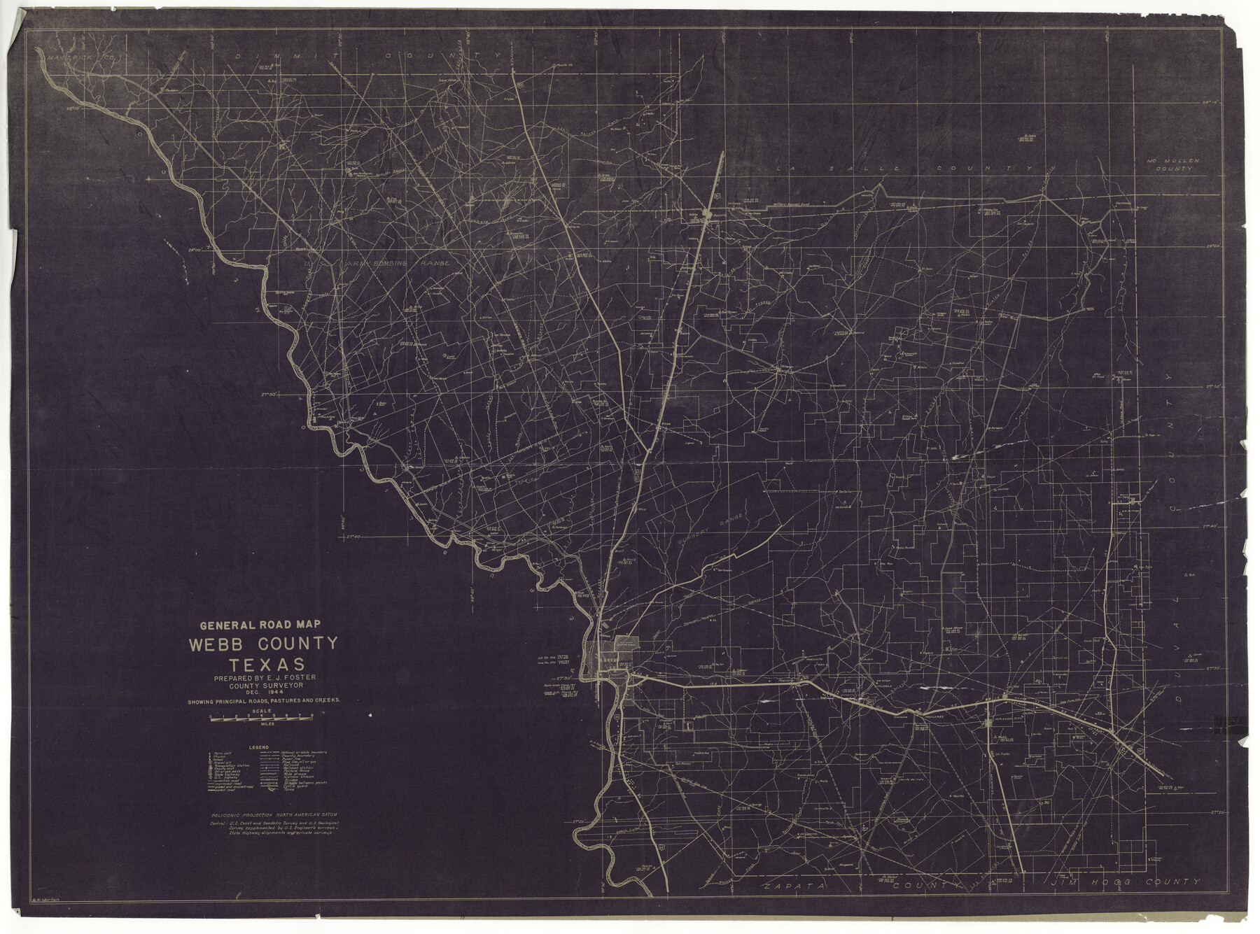
General Road Map, Webb County, Texas
-
Map/Doc
10126
-
Collection
General Map Collection
-
Object Dates
1944 (Creation Date)
1945/9/6 (File Date)
-
People and Organizations
Webb County (Publisher)
E.J. Foster (Compiler)
G.W. Morton (Draftsman)
E.J. Foster (Surveyor/Engineer)
-
Counties
Webb
-
Subjects
County
-
Height x Width
37.1 x 50.0 inches
94.2 x 127.0 cm
-
Comments
Note on back: "Map showing roads, creeks, and triangulation stations and giving coordinates of same. Prepared by E. Foster, Co. Surveyor, Dec. 1944".; formerly Webb County Rolled Sketch 55. Shows many homesteads/rancheros.
-
Features
Corrizo Springs Road
Eagle Pass Road
Borrego Creek
Valenzuela Creek
Buena Vista
Catarina Road
Piloncilla Hill
Highway 83
Espejo Creek
Lorenzo Creek
Chupadero
San Ambrosio Creek
Twin Peaks
Dos Hermanas Mountains
Arroyo Tierritas Blancas
Blanco Creek
Las Raices Creek
Jaboncillos Creek
Prairie View School
San Antonio Road
San Casimiro Creek
Freer Road
Dolores Creek
Charco Largo Creek
Withers to Encinal Road
Withers Road
Encinal Road
Encinal
Cuchara Creek
Dordillo Creek
San Cirildo Creek
Little Apache Hill
Buena Vista Road
Pinto Creek
El Venado Creek
Los Olmos Creek
Pintas Parida Creek
Charamusco Creek
Buenavista School
Carrizilos Creek
Cactus
Cerrito Prieto Mountain
Palo Blanco Creek
Loma Blanca Mountain
Big Apache Hill
Espada Creek
San Pedro Hill
Carricitos Creek
Santa Isabel Creek
Callaghan
MP
Salado Creek
La Moca Road
El Doctor Road
El Lato Road
Caliches Creek
Highway 81
Sombreretillo Creek
El Cuervo Creek
Tordillo Creek
Tordillo Settlement
Santo Tomas
Darwin
Cannel
Islitas [sic]
San Pablo
San Ygnacio Creek
Manadas Creek
Chacon Creek
Laredo
Pescadito
Villegas
Highway 59
Reiser Creek
Oilton
Bruni
Corpus Christi Road
Laurel
Los Ojuelos
Mirando City
Aguilares
Raup Creek
Eistler Road
Pitato Mangana Road
Jennings Road
Becerrita Creek
Agua Azul Creek
Burritas Hill
San Juanito Creek
Dolores
Blancas Creek
Becerra Creek
Jaral Creek
Las Albercas Creek
James Carr Ranch
H. Garcia Rancho
J. Rector Rancho
G. Lyles Ranch
Brown Rancho
Ojitas Rancho
C. Chanault Rancho
Mrs. Brown's Rancho
Charamusco Rancho
G. Adami Rancho
San Casimiro Rancho
Mancillas Rancho
Las Comas Rancho
Vidalis Rancho
Mrs. B. Carr Ranch
B. B. Dunbar Ranch
Pilotes Rancho
Granades Rancho
T. Ramos Rancho
Cushillo Rancho
Jabalina Rancho
Potts Ranch
Sanchez Rancho
Rodriguez Rancho
San Roman Rancho
Wilkins Rancho
Reyna Rancho
J. Guerra Rancho
Los Olmos Rancho
El Junco Rancho
Lincoln Ranch
Bacerra Rancho
Cenizal Rancho
Las Pintas Rancho
L. Adami Ranch
P. Adami Ranch
Chihuahua Rancho
Las Tiendas Rancho
Denteno Rancho
J. Gonzales Rancho
Dowling Ranch
La Mesa Rancho
Raices
Palo Blanco Rancho
Trevino Rancho
Tejones Rancho
Mendiolena Rancho
Farrel Ranch
La Volanta Rancho
Alamito Rancho
Las Mujeras Rancho
Molinos Rancho
Tinajas Rancho
Hirsch Ranch
San Carlos Rancho
Las Lomas Rancho
Poole Ranch
Minera Rancho
Dolores Rancho
Simon Ranch
Isabel Rancho
Pedro Parada Rancho
Centreras Rancho
Gliches Rancho
Arroyo Blanco
Buey Ranch
Alamito Creek
El Gato Creek
Sandia Ranch
Los Tejones Creek
Llave Creek
Santo Tomas Creek
Palafox
Milo
San Pablo School
RG&EP
Proposed Houston Highway
North Bruni Road
[Road] to Monterrey
[Road] to North Rosita Mexico
Rancho Chico
Cerrito del Indio
Part of: General Map Collection
Flight Mission No. DAG-17K, Frame 63, Matagorda County

Print $20.00
- Digital $50.00
Flight Mission No. DAG-17K, Frame 63, Matagorda County
1952
Size 18.6 x 22.3 inches
Map/Doc 86325
Val Verde County Sketch File 4

Print $30.00
- Digital $50.00
Val Verde County Sketch File 4
1888
Size 28.0 x 20.6 inches
Map/Doc 12561
Flight Mission No. BQR-22K, Frame 45, Brazoria County

Print $20.00
- Digital $50.00
Flight Mission No. BQR-22K, Frame 45, Brazoria County
1953
Size 18.7 x 22.4 inches
Map/Doc 84129
Lamar County Sketch File 1

Print $4.00
- Digital $50.00
Lamar County Sketch File 1
1849
Size 8.0 x 8.2 inches
Map/Doc 29271
Presidio County Rolled Sketch 71

Print $20.00
- Digital $50.00
Presidio County Rolled Sketch 71
1941
Size 31.7 x 42.9 inches
Map/Doc 7361
Lipscomb County

Print $20.00
- Digital $50.00
Lipscomb County
1878
Size 18.1 x 16.4 inches
Map/Doc 3816
Flight Mission No. BRA-8M, Frame 26, Jefferson County

Print $20.00
- Digital $50.00
Flight Mission No. BRA-8M, Frame 26, Jefferson County
1953
Size 18.6 x 22.3 inches
Map/Doc 85581
[Subdivision of Nueces Bay and list of Court Decrees]
![2086, [Subdivision of Nueces Bay and list of Court Decrees], General Map Collection](https://historictexasmaps.com/wmedia_w700/maps/2086-1.tif.jpg)
Print $40.00
- Digital $50.00
[Subdivision of Nueces Bay and list of Court Decrees]
1940
Size 34.2 x 48.8 inches
Map/Doc 2086
San Jacinto County Sketch File 10

Print $5.00
San Jacinto County Sketch File 10
1859
Size 11.7 x 6.6 inches
Map/Doc 35714
Denton County Sketch File 15

Print $8.00
- Digital $50.00
Denton County Sketch File 15
1857
Size 13.1 x 8.2 inches
Map/Doc 20724
Sutton County Sketch File A

Print $5.00
- Digital $50.00
Sutton County Sketch File A
Size 9.1 x 11.9 inches
Map/Doc 37389
Madison County Working Sketch 12

Print $40.00
- Digital $50.00
Madison County Working Sketch 12
1965
Size 41.7 x 48.5 inches
Map/Doc 70774
You may also like
Ward County Working Sketch 38

Print $40.00
- Digital $50.00
Ward County Working Sketch 38
1969
Size 62.2 x 30.3 inches
Map/Doc 72344
Nueces County Sketch File 4

Print $4.00
- Digital $50.00
Nueces County Sketch File 4
1848
Size 10.1 x 8.0 inches
Map/Doc 32505
Montgomery County

Print $20.00
- Digital $50.00
Montgomery County
1861
Size 18.5 x 22.6 inches
Map/Doc 78283
McLennan County Sketch File 22

Print $3.00
- Digital $50.00
McLennan County Sketch File 22
1869
Size 11.1 x 9.3 inches
Map/Doc 31296
Gaines County Working Sketch 31

Print $20.00
- Digital $50.00
Gaines County Working Sketch 31
1990
Size 37.4 x 26.8 inches
Map/Doc 69331
Wharton County Working Sketch 20

Print $20.00
- Digital $50.00
Wharton County Working Sketch 20
1938
Size 39.1 x 42.2 inches
Map/Doc 72484
Andrews County

Print $40.00
- Digital $50.00
Andrews County
1925
Size 56.5 x 42.8 inches
Map/Doc 89866
San Augustine County Working Sketch 1

Print $3.00
- Digital $50.00
San Augustine County Working Sketch 1
1906
Size 9.1 x 11.3 inches
Map/Doc 63688
Aransas County Sketch File 38

Print $244.00
- Digital $50.00
Aransas County Sketch File 38
1996
Size 11.1 x 8.7 inches
Map/Doc 13465
Val Verde County Rolled Sketch 76

Print $20.00
- Digital $50.00
Val Verde County Rolled Sketch 76
1976
Size 38.6 x 26.6 inches
Map/Doc 8139
Leon County Rolled Sketch 6

Print $20.00
- Digital $50.00
Leon County Rolled Sketch 6
1951
Size 31.6 x 37.6 inches
Map/Doc 6597
Morris County Rolled Sketch 2A

Print $20.00
- Digital $50.00
Morris County Rolled Sketch 2A
Size 36.2 x 19.3 inches
Map/Doc 10282