Gaines County Sketch File 8
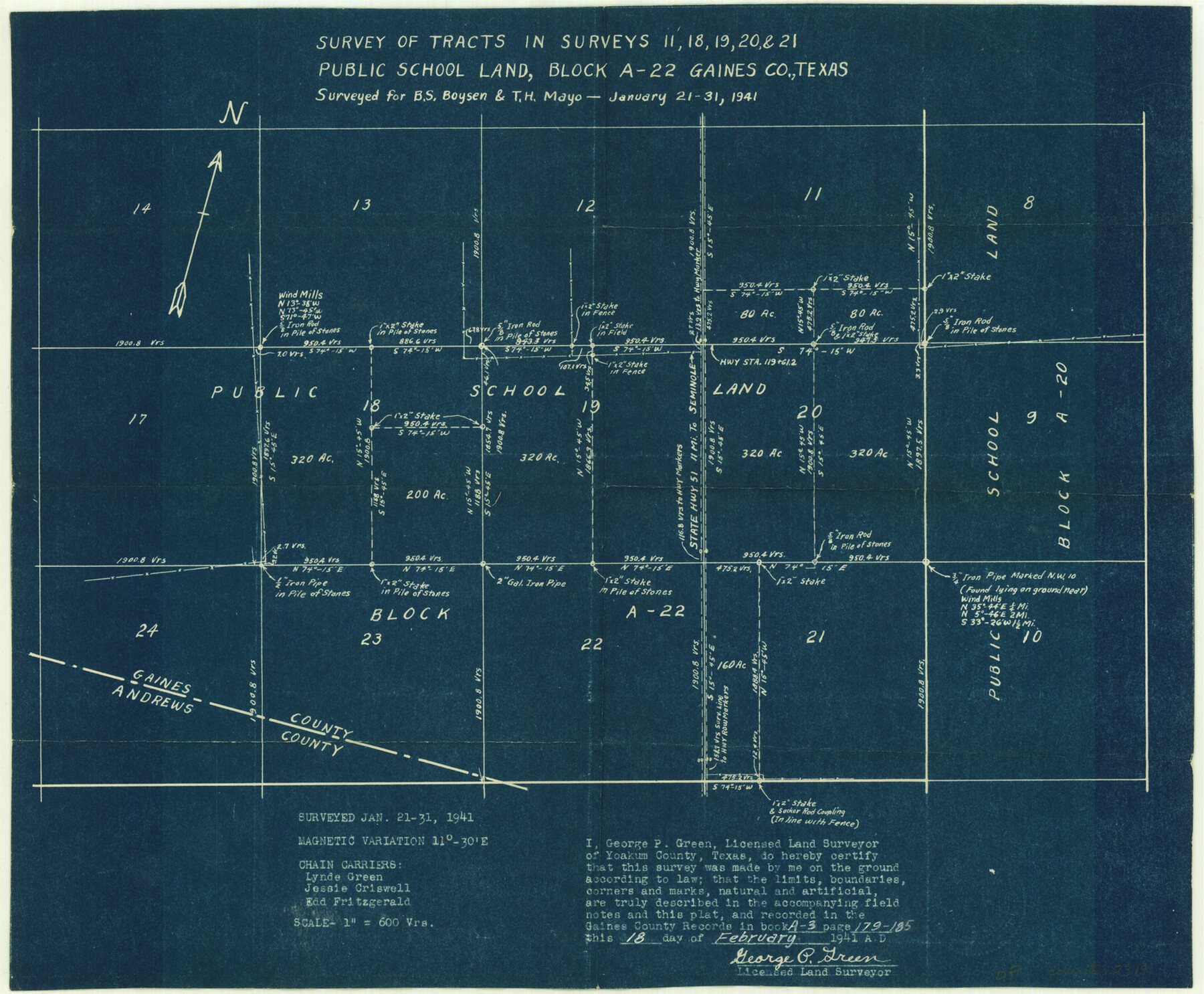
Survey of tracts in surveys 11, 18, 19, 20 and 21, Public School Land, Block A-22]
-
Map/Doc
23191
-
Collection
General Map Collection
-
Object Dates
1941/1/18 (Creation Date)
1941/2/26 (File Date)
1941/1/31 (Survey Date)
-
People and Organizations
George P. Green (Surveyor/Engineer)
Lynde Green (Chainman)
Jessie Criswell (Chainman)
Edd Fritzgerald (Chainman)
-
Counties
Gaines Andrews
-
Subjects
Surveying Sketch File
-
Height x Width
14.2 x 17.2 inches
36.1 x 43.7 cm
-
Medium
blueprint/diazo
-
Scale
1:600
Part of: General Map Collection
Panola County Sketch File 23

Print $20.00
- Digital $50.00
Panola County Sketch File 23
Size 23.1 x 17.5 inches
Map/Doc 12139
Tyler County Sketch File 17b

Print $4.00
- Digital $50.00
Tyler County Sketch File 17b
Size 12.0 x 8.0 inches
Map/Doc 38666
Brazos County Working Sketch 10

Print $20.00
- Digital $50.00
Brazos County Working Sketch 10
1991
Size 15.8 x 20.7 inches
Map/Doc 67485
Chambers County Sketch File 44

Print $36.00
- Digital $50.00
Chambers County Sketch File 44
Size 13.9 x 8.7 inches
Map/Doc 17735
Florida called by ye French Louisiana & c.

Print $20.00
- Digital $50.00
Florida called by ye French Louisiana & c.
1728
Size 9.6 x 14.3 inches
Map/Doc 94110
Flight Mission No. CUG-3P, Frame 12, Kleberg County

Print $20.00
- Digital $50.00
Flight Mission No. CUG-3P, Frame 12, Kleberg County
1956
Size 18.5 x 22.3 inches
Map/Doc 86222
Bastrop County Working Sketch 1

Print $20.00
- Digital $50.00
Bastrop County Working Sketch 1
1913
Size 24.8 x 21.3 inches
Map/Doc 67301
Aransas County Sketch File 21b

Print $4.00
- Digital $50.00
Aransas County Sketch File 21b
Size 8.7 x 14.2 inches
Map/Doc 13160
Map of the East Part of Tom Green County

Print $40.00
- Digital $50.00
Map of the East Part of Tom Green County
1894
Size 45.9 x 49.4 inches
Map/Doc 63071
[Map of Block 97, Borden and Scurry Co (Exhibit A); Map of Southeastern part of Young Territory; Map of part of of Borden, Fisher, Kent, Mitchell, Scurry and Garza Cos. Showing the north boundary line of the T&P 80 mile reservation]
![65693, [Map of Block 97, Borden and Scurry Co (Exhibit A); Map of Southeastern part of Young Territory; Map of part of of Borden, Fisher, Kent, Mitchell, Scurry and Garza Cos. Showing the north boundary line of the T&P 80 mile reservation], General Map Collection](https://historictexasmaps.com/wmedia_w700/maps/65693.tif.jpg)
Print $20.00
- Digital $50.00
[Map of Block 97, Borden and Scurry Co (Exhibit A); Map of Southeastern part of Young Territory; Map of part of of Borden, Fisher, Kent, Mitchell, Scurry and Garza Cos. Showing the north boundary line of the T&P 80 mile reservation]
1901
Size 31.2 x 23.3 inches
Map/Doc 65693
Presidio County Rolled Sketch 69

Print $20.00
- Digital $50.00
Presidio County Rolled Sketch 69
1927
Size 36.5 x 14.1 inches
Map/Doc 7359

You may also like
Presidio County Working Sketch 63

Print $40.00
- Digital $50.00
Presidio County Working Sketch 63
1958
Size 64.8 x 38.9 inches
Map/Doc 71740
Flight Mission No. DQN-2K, Frame 26, Calhoun County

Print $20.00
- Digital $50.00
Flight Mission No. DQN-2K, Frame 26, Calhoun County
1953
Size 18.6 x 22.2 inches
Map/Doc 84233
Briscoe County Rolled Sketch 16

Print $20.00
- Digital $50.00
Briscoe County Rolled Sketch 16
1934
Size 17.8 x 19.9 inches
Map/Doc 5330
Flight Mission No. DQN-1K, Frame 45, Calhoun County

Print $20.00
- Digital $50.00
Flight Mission No. DQN-1K, Frame 45, Calhoun County
1953
Size 15.8 x 15.6 inches
Map/Doc 84145
Flight Mission No. BRA-16M, Frame 145, Jefferson County

Print $20.00
- Digital $50.00
Flight Mission No. BRA-16M, Frame 145, Jefferson County
1953
Size 18.7 x 22.3 inches
Map/Doc 85751
Johnson County Working Sketch 13

Print $20.00
- Digital $50.00
Johnson County Working Sketch 13
1969
Size 32.0 x 41.0 inches
Map/Doc 66626
Map of Swisher Addition

Print $20.00
- Digital $50.00
Map of Swisher Addition
1910
Size 18.0 x 13.1 inches
Map/Doc 83425
Gray County Sketch File 14

Print $4.00
- Digital $50.00
Gray County Sketch File 14
1946
Size 11.3 x 8.9 inches
Map/Doc 24457
Gregg County Working Sketch 16

Print $20.00
- Digital $50.00
Gregg County Working Sketch 16
1944
Size 14.8 x 27.9 inches
Map/Doc 63283
Garza County Rolled Sketch R1

Print $40.00
- Digital $50.00
Garza County Rolled Sketch R1
Size 32.1 x 49.3 inches
Map/Doc 9045
Terrell County Working Sketch 40

Print $20.00
- Digital $50.00
Terrell County Working Sketch 40
1956
Size 22.9 x 29.1 inches
Map/Doc 62133
[Surveys along the Sabine River made under G.W. Smyth, Commissioner]
![90, [Surveys along the Sabine River made under G.W. Smyth, Commissioner], General Map Collection](https://historictexasmaps.com/wmedia_w700/maps/90.tif.jpg)
Print $20.00
- Digital $50.00
[Surveys along the Sabine River made under G.W. Smyth, Commissioner]
1837
Size 13.9 x 17.0 inches
Map/Doc 90