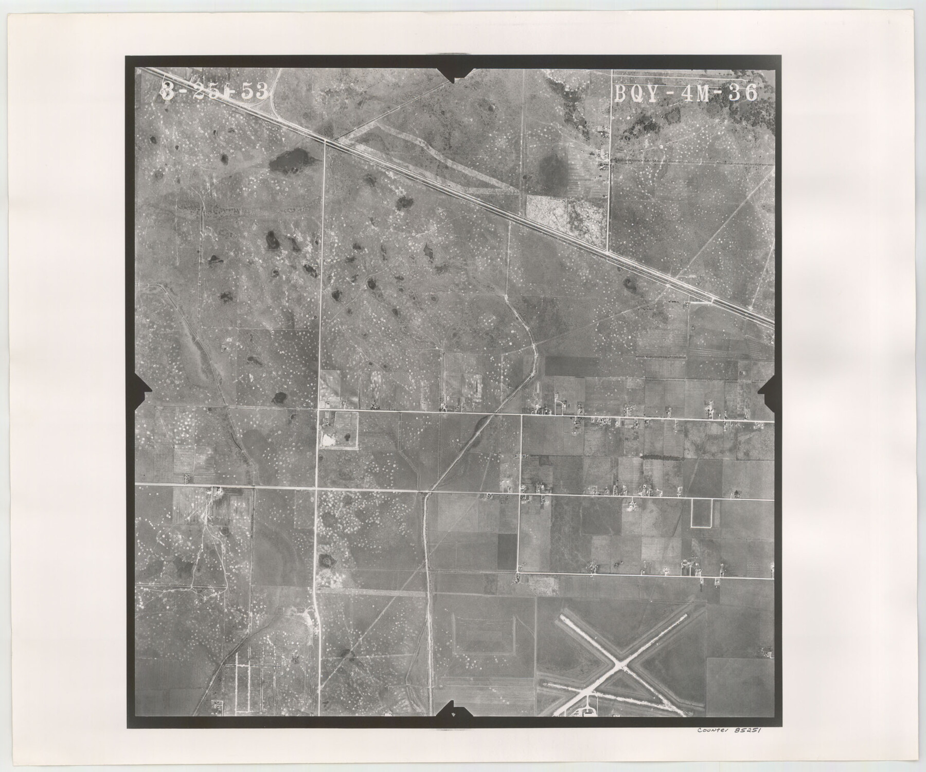
Flight Mission No. BQY-4M, Frame 36, Harris County
BQY-4M-36
-
Map/Doc
85251
-
Collection
General Map Collection
-
Object Dates
1953/3/25 (Creation Date)
-
People and Organizations
U. S. Department of Agriculture (Publisher)
-
Counties
Harris
-
Subjects
Aerial Photograph
-
Height x Width
18.6 x 22.3 inches
47.2 x 56.6 cm
-
Comments
Flown by Jack Ammann Photogrammetric Engineers of San Antonio, Texas.
Part of: General Map Collection
Terry County Rolled Sketch 4

Print $20.00
- Digital $50.00
Terry County Rolled Sketch 4
Size 38.7 x 36.8 inches
Map/Doc 9994
Edwards County Working Sketch 120

Print $40.00
- Digital $50.00
Edwards County Working Sketch 120
1975
Size 25.0 x 48.9 inches
Map/Doc 68996
Edwards County Rolled Sketch 29

Print $40.00
- Digital $50.00
Edwards County Rolled Sketch 29
1974
Size 49.1 x 29.1 inches
Map/Doc 8847
Burnet County Sketch File 30

Print $4.00
- Digital $50.00
Burnet County Sketch File 30
Size 11.0 x 8.0 inches
Map/Doc 16746
Guadalupe County Working Sketch 11

Print $40.00
- Digital $50.00
Guadalupe County Working Sketch 11
1972
Size 67.7 x 45.0 inches
Map/Doc 63320
Coryell County Working Sketch 27

Print $20.00
- Digital $50.00
Coryell County Working Sketch 27
1988
Size 15.5 x 20.0 inches
Map/Doc 68234
Harris County Sketch File 57

Print $15.00
- Digital $50.00
Harris County Sketch File 57
1919
Size 8.8 x 7.7 inches
Map/Doc 25473
Current Miscellaneous File 15

Print $16.00
- Digital $50.00
Current Miscellaneous File 15
1951
Size 10.7 x 8.2 inches
Map/Doc 73822
Gillespie County Sketch File 7

Print $4.00
- Digital $50.00
Gillespie County Sketch File 7
1872
Size 7.7 x 7.3 inches
Map/Doc 24141
Dimmit County Working Sketch 27

Print $20.00
- Digital $50.00
Dimmit County Working Sketch 27
1956
Size 20.3 x 23.0 inches
Map/Doc 68688
El Paso County Rolled Sketch 52

Print $20.00
- Digital $50.00
El Paso County Rolled Sketch 52
1955
Size 18.5 x 24.3 inches
Map/Doc 5840
Duval County Rolled Sketch 13

Print $20.00
- Digital $50.00
Duval County Rolled Sketch 13
1937
Size 33.8 x 30.4 inches
Map/Doc 5735
You may also like
Val Verde County Sketch File 40A

Print $4.00
- Digital $50.00
Val Verde County Sketch File 40A
1939
Size 11.3 x 8.9 inches
Map/Doc 39307
Austin County Rolled Sketch 4

Print $20.00
- Digital $50.00
Austin County Rolled Sketch 4
Size 30.8 x 44.8 inches
Map/Doc 8435
[Surveys in the Victoria District along the Guadalupe and Coleto Rivers]
![21, [Surveys in the Victoria District along the Guadalupe and Coleto Rivers], General Map Collection](https://historictexasmaps.com/wmedia_w700/maps/21.tif.jpg)
Print $20.00
- Digital $50.00
[Surveys in the Victoria District along the Guadalupe and Coleto Rivers]
1840
Size 26.0 x 19.6 inches
Map/Doc 21
Eastland County Boundary File 13

Print $68.00
- Digital $50.00
Eastland County Boundary File 13
Size 8.0 x 3.7 inches
Map/Doc 52785
Kerr County Working Sketch 12

Print $20.00
- Digital $50.00
Kerr County Working Sketch 12
1951
Size 34.3 x 37.0 inches
Map/Doc 70043
[Blocks XO3 and I]
![91167, [Blocks XO3 and I], Twichell Survey Records](https://historictexasmaps.com/wmedia_w700/maps/91167-1.tif.jpg)
Print $2.00
- Digital $50.00
[Blocks XO3 and I]
Size 6.5 x 11.8 inches
Map/Doc 91167
Map of Glasscock County, Texas

Print $20.00
Map of Glasscock County, Texas
Size 22.7 x 18.3 inches
Map/Doc 88943
Flight Mission No. DAG-21K, Frame 133, Matagorda County

Print $20.00
- Digital $50.00
Flight Mission No. DAG-21K, Frame 133, Matagorda County
1952
Size 18.6 x 22.4 inches
Map/Doc 86459
Atascosa County

Print $20.00
- Digital $50.00
Atascosa County
1948
Size 47.6 x 44.9 inches
Map/Doc 77204
[Movements & Objectives of the 143rd & 144th Infantry and many other divisions and regiments, 1918] - Verso
![94139, [Movements & Objectives of the 143rd & 144th Infantry and many other divisions and regiments, 1918] - Verso, Non-GLO Digital Images](https://historictexasmaps.com/wmedia_w700/maps/94139-1.tif.jpg)
Print $40.00
[Movements & Objectives of the 143rd & 144th Infantry and many other divisions and regiments, 1918] - Verso
1918
Size 37.2 x 63.9 inches
Map/Doc 94139
Parker County Working Sketch 4

Print $20.00
- Digital $50.00
Parker County Working Sketch 4
1941
Map/Doc 71454
Pecos County Working Sketch Graphic Index - south part

Print $20.00
- Digital $50.00
Pecos County Working Sketch Graphic Index - south part
1976
Size 35.3 x 43.2 inches
Map/Doc 76665