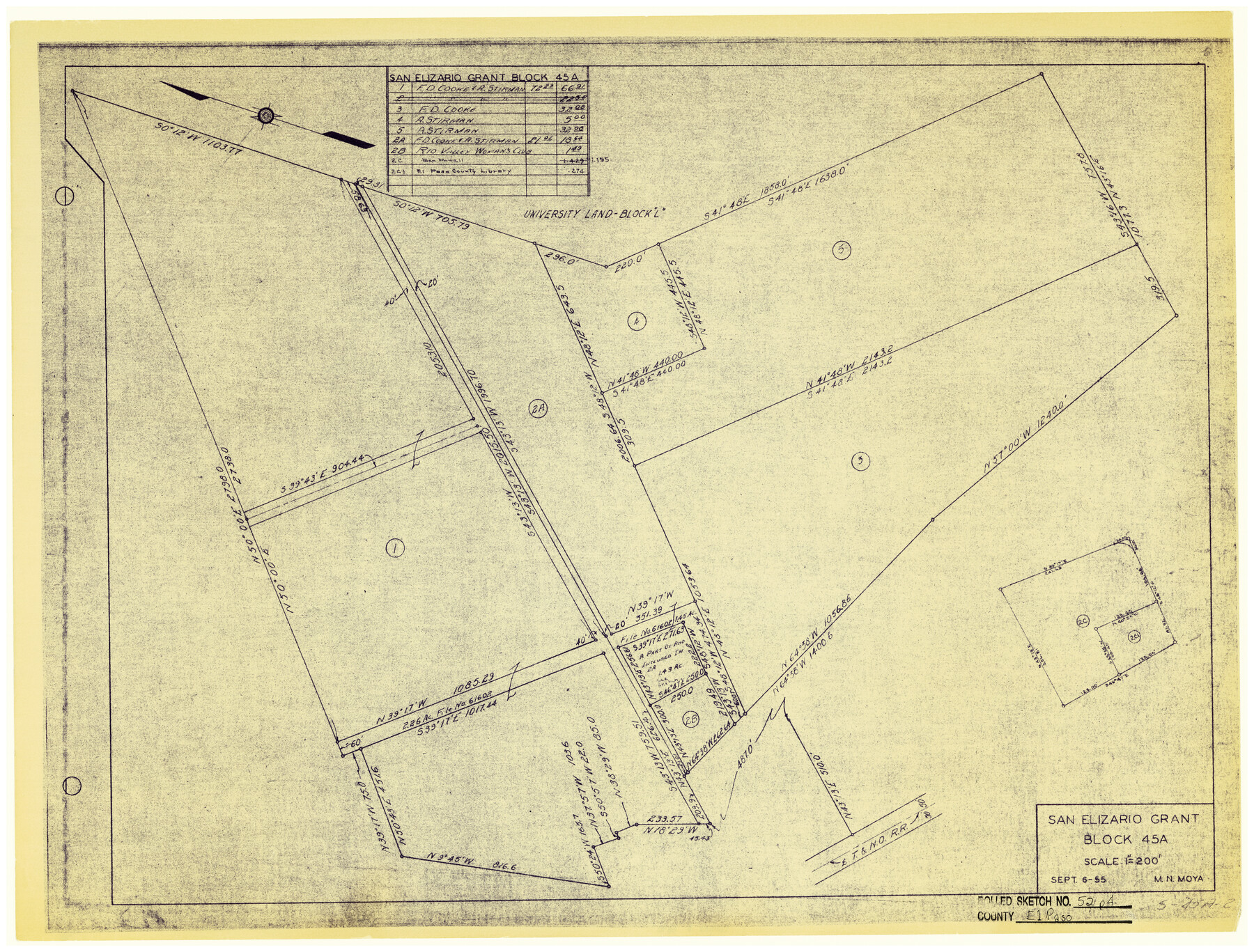
El Paso County Rolled Sketch 52
San Elizario Grant - Block No. 45A
-
Map/Doc
5840
-
Collection
General Map Collection
-
Object Dates
9/6/1955 (Creation Date)
10/23/1974 (File Date)
-
Counties
El Paso
-
Subjects
Surveying Rolled Sketch
-
Height x Width
18.5 x 24.3 inches
47.0 x 61.7 cm
-
Medium
blueprint/diazo
-
Scale
1" = 200 feet
Part of: General Map Collection
Flight Mission No. BRA-7M, Frame 6, Jefferson County

Print $20.00
- Digital $50.00
Flight Mission No. BRA-7M, Frame 6, Jefferson County
1953
Size 18.5 x 22.3 inches
Map/Doc 85457

Glasscock County Sketch File 21

Print $20.00
- Digital $50.00
Glasscock County Sketch File 21
1936
Size 23.1 x 20.3 inches
Map/Doc 11564
Potter County Working Sketch 12

Print $40.00
- Digital $50.00
Potter County Working Sketch 12
1972
Size 64.4 x 42.4 inches
Map/Doc 71672
Johnson County Sketch File 23

Print $22.00
- Digital $50.00
Johnson County Sketch File 23
1857
Size 8.1 x 12.6 inches
Map/Doc 28456
Flight Mission No. DCL-6C, Frame 122, Kenedy County

Print $20.00
- Digital $50.00
Flight Mission No. DCL-6C, Frame 122, Kenedy County
1943
Size 18.5 x 22.4 inches
Map/Doc 85952
Flight Mission No. CRK-8P, Frame 98, Refugio County

Print $20.00
- Digital $50.00
Flight Mission No. CRK-8P, Frame 98, Refugio County
1956
Size 18.2 x 22.0 inches
Map/Doc 86959
Borden County Boundary File 2

Print $22.00
- Digital $50.00
Borden County Boundary File 2
Size 13.6 x 8.7 inches
Map/Doc 50614
Navarro County Working Sketch 15

Print $20.00
- Digital $50.00
Navarro County Working Sketch 15
1993
Size 16.1 x 17.8 inches
Map/Doc 71245
Sabine and Neches Rivers

Print $20.00
- Digital $50.00
Sabine and Neches Rivers
1987
Size 19.6 x 44.7 inches
Map/Doc 69820
Upton County Sketch File 22

Print $4.00
- Digital $50.00
Upton County Sketch File 22
1927
Size 11.2 x 8.5 inches
Map/Doc 38877
Flight Mission No. CRC-5R, Frame 24, Chambers County

Print $20.00
- Digital $50.00
Flight Mission No. CRC-5R, Frame 24, Chambers County
1956
Size 18.7 x 22.4 inches
Map/Doc 84946
You may also like

Right of Way & Track Map, St. Louis, Brownsville & Mexico Ry. operated by St. Louis, Brownsville & Mexico Ry. Co.

Print $40.00
- Digital $50.00
Right of Way & Track Map, St. Louis, Brownsville & Mexico Ry. operated by St. Louis, Brownsville & Mexico Ry. Co.
1919
Size 25.5 x 57.0 inches
Map/Doc 64626
Lynn County Rolled Sketch B

Print $20.00
- Digital $50.00
Lynn County Rolled Sketch B
1908
Size 27.9 x 33.1 inches
Map/Doc 6653
General Highway Map, Refugio County, Texas

Print $20.00
General Highway Map, Refugio County, Texas
1961
Size 18.1 x 24.7 inches
Map/Doc 79639
Jeff Davis County Boundary File 2

Print $14.00
- Digital $50.00
Jeff Davis County Boundary File 2
Size 14.3 x 8.8 inches
Map/Doc 55505
Hood County Sketch File 5

Print $4.00
- Digital $50.00
Hood County Sketch File 5
1884
Size 9.1 x 5.7 inches
Map/Doc 26577
Northern Part of Laguna Madre

Print $20.00
- Digital $50.00
Northern Part of Laguna Madre
1965
Size 44.5 x 35.0 inches
Map/Doc 73526
Coke County Rolled Sketch 8

Print $20.00
- Digital $50.00
Coke County Rolled Sketch 8
Size 26.5 x 34.8 inches
Map/Doc 5507
Culberson County Sketch File 37

Print $20.00
- Digital $50.00
Culberson County Sketch File 37
1961
Size 24.8 x 18.5 inches
Map/Doc 11273
Yellow House Land Company's Subdivision of State Capitol Leagues Hockley and Lamb Counties, Texas

Print $20.00
- Digital $50.00
Yellow House Land Company's Subdivision of State Capitol Leagues Hockley and Lamb Counties, Texas
Size 22.4 x 23.0 inches
Map/Doc 92206
Flight Mission No. CRC-2R, Frame 195, Chambers County

Print $20.00
- Digital $50.00
Flight Mission No. CRC-2R, Frame 195, Chambers County
1956
Size 18.6 x 22.3 inches
Map/Doc 84773
Hays County Sketch File 22

Print $4.00
- Digital $50.00
Hays County Sketch File 22
Size 8.4 x 7.3 inches
Map/Doc 26249