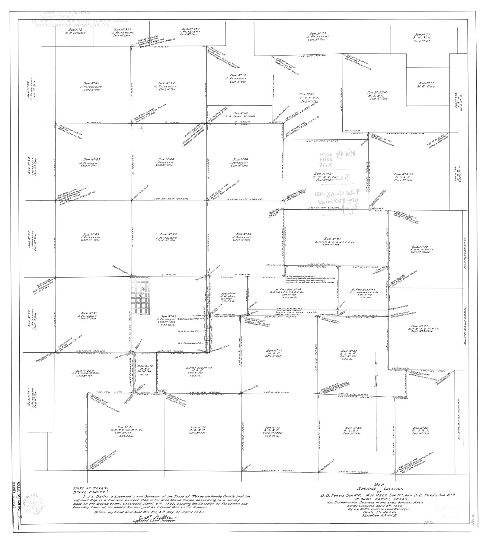
Duval County Rolled Sketch 13
Map showing location of D.B. Purvis sur. no. 8, M.H. Reed sur. no. 1 & D.B. Purvis sur. no. 9 in Duval County, Texas and surrounding surveys in the same general area
-
Map/Doc
5735
-
Collection
General Map Collection
-
Object Dates
1937/4/6 (Creation Date)
1937/4/8 (File Date)
-
People and Organizations
J.L. Dellis (Surveyor/Engineer)
-
Counties
Duval
-
Subjects
Surveying Rolled Sketch
-
Height x Width
33.8 x 30.4 inches
85.9 x 77.2 cm
-
Scale
1" = 400 varas
Part of: General Map Collection
[Surveys in Vehlein's Colony along the San Jacinto River and Cedar Bayou]
![75, [Surveys in Vehlein's Colony along the San Jacinto River and Cedar Bayou], General Map Collection](https://historictexasmaps.com/wmedia_w700/maps/75.tif.jpg)
Print $20.00
- Digital $50.00
[Surveys in Vehlein's Colony along the San Jacinto River and Cedar Bayou]
1837
Size 17.5 x 15.1 inches
Map/Doc 75
Reeves County Rolled Sketch 28

Print $20.00
- Digital $50.00
Reeves County Rolled Sketch 28
1985
Size 28.1 x 40.1 inches
Map/Doc 7497
Dimmit County Sketch File 9a

Print $4.00
- Digital $50.00
Dimmit County Sketch File 9a
Size 12.7 x 8.2 inches
Map/Doc 21073
Flight Mission No. DIX-10P, Frame 66, Aransas County

Print $20.00
- Digital $50.00
Flight Mission No. DIX-10P, Frame 66, Aransas County
1956
Size 18.8 x 22.5 inches
Map/Doc 83927
Panola County Working Sketch 35

Print $40.00
- Digital $50.00
Panola County Working Sketch 35
1983
Map/Doc 71444
Cass County Working Sketch 29

Print $20.00
- Digital $50.00
Cass County Working Sketch 29
1979
Size 38.4 x 23.5 inches
Map/Doc 67932
[Map of the Fort Worth & Denver City Railway]
![64432, [Map of the Fort Worth & Denver City Railway], General Map Collection](https://historictexasmaps.com/wmedia_w700/maps/64432.tif.jpg)
Print $40.00
- Digital $50.00
[Map of the Fort Worth & Denver City Railway]
1887
Size 21.3 x 122.7 inches
Map/Doc 64432
Dimmit County Sketch File 50

Print $36.00
- Digital $50.00
Dimmit County Sketch File 50
1909
Size 18.2 x 20.4 inches
Map/Doc 21181
Duval County Sketch File 32b

Print $6.00
- Digital $50.00
Duval County Sketch File 32b
Size 14.2 x 8.9 inches
Map/Doc 21339
Nueces County Rolled Sketch 62

Print $20.00
- Digital $50.00
Nueces County Rolled Sketch 62
1977
Size 25.0 x 33.3 inches
Map/Doc 6908
Flight Mission No. DCL-7C, Frame 48, Kenedy County

Print $20.00
- Digital $50.00
Flight Mission No. DCL-7C, Frame 48, Kenedy County
1943
Size 16.6 x 16.5 inches
Map/Doc 86036
Haskell County Rolled Sketch 15A

Print $3.00
- Digital $50.00
Haskell County Rolled Sketch 15A
1991
Size 11.3 x 17.1 inches
Map/Doc 6174
You may also like
Presidio County Sketch File 31

Print $20.00
- Digital $50.00
Presidio County Sketch File 31
Size 11.4 x 20.8 inches
Map/Doc 11712
Presidio County Rolled Sketch T-4

Print $20.00
- Digital $50.00
Presidio County Rolled Sketch T-4
Size 46.6 x 21.7 inches
Map/Doc 10085
Val Verde County Rolled Sketch 72

Print $20.00
- Digital $50.00
Val Verde County Rolled Sketch 72
Size 15.2 x 28.5 inches
Map/Doc 8134
Flight Mission No. DQO-8K, Frame 133, Galveston County

Print $20.00
- Digital $50.00
Flight Mission No. DQO-8K, Frame 133, Galveston County
1952
Size 18.8 x 22.5 inches
Map/Doc 85198
Reagan County Working Sketch 29

Print $40.00
- Digital $50.00
Reagan County Working Sketch 29
1963
Size 34.3 x 66.4 inches
Map/Doc 71871
Terrell County Rolled Sketch 49

Print $20.00
- Digital $50.00
Terrell County Rolled Sketch 49
1962
Size 17.3 x 24.1 inches
Map/Doc 7951
[State Capitol Leagues, County School Leagues, and vicinity]
![92535, [State Capitol Leagues, County School Leagues, and vicinity], Twichell Survey Records](https://historictexasmaps.com/wmedia_w700/maps/92535-1.tif.jpg)
Print $20.00
- Digital $50.00
[State Capitol Leagues, County School Leagues, and vicinity]
1913
Size 20.8 x 27.6 inches
Map/Doc 92535

Milam County Working Sketch 9

Print $20.00
- Digital $50.00
Milam County Working Sketch 9
1976
Size 27.2 x 22.7 inches
Map/Doc 71024
Cass County Working Sketch 38

Print $20.00
- Digital $50.00
Cass County Working Sketch 38
1982
Size 19.2 x 21.0 inches
Map/Doc 67941
Hudspeth County Sketch File 47

Print $30.00
- Digital $50.00
Hudspeth County Sketch File 47
1978
Size 14.5 x 8.9 inches
Map/Doc 27050
W. L. Ellwood's Subdivision of Parts of Leagues 9 and 10, Donley County School Land, 7 Wilbarger County School Land and Parts of Section 50, 61, and 74, Block 20 Hockley County, Texas

Print $20.00
- Digital $50.00
W. L. Ellwood's Subdivision of Parts of Leagues 9 and 10, Donley County School Land, 7 Wilbarger County School Land and Parts of Section 50, 61, and 74, Block 20 Hockley County, Texas
1923
Size 20.2 x 19.8 inches
Map/Doc 92249