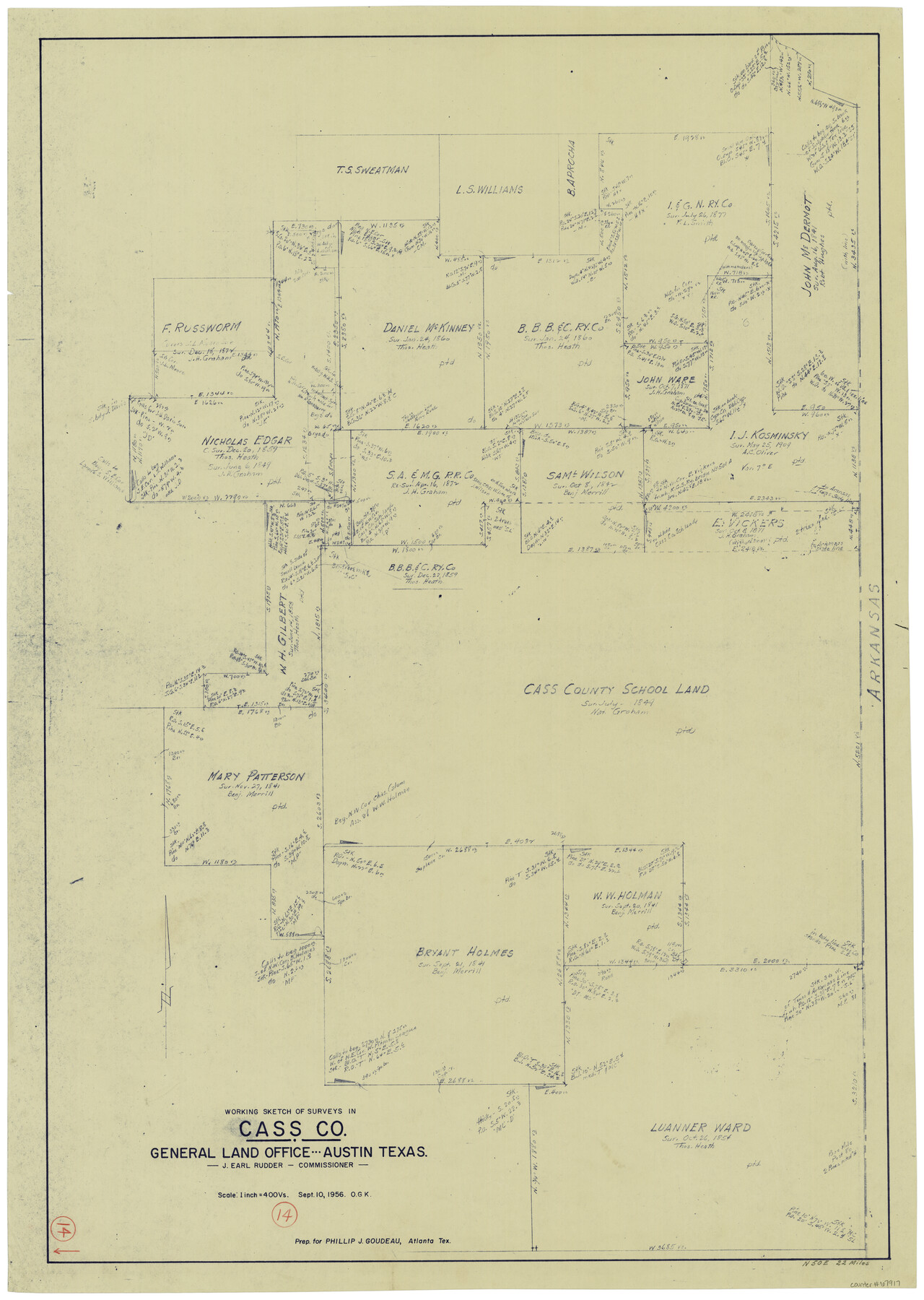
Cass County Working Sketch 14
-
Map/Doc
67917
-
Collection
General Map Collection
-
Object Dates
9/10/1956 (Creation Date)
-
People and Organizations
Otto G. Kurio (Draftsman)
-
Counties
Cass
-
Subjects
Surveying Working Sketch
-
Height x Width
36.7 x 26.4 inches
93.2 x 67.1 cm
-
Scale
1" = 400 varas
Part of: General Map Collection
Brewster County Rolled Sketch 96

Print $20.00
- Digital $50.00
Brewster County Rolled Sketch 96
1951
Size 21.7 x 33.7 inches
Map/Doc 5253
Presidio County Rolled Sketch 131A

Print $20.00
- Digital $50.00
Presidio County Rolled Sketch 131A
1975
Size 30.5 x 24.9 inches
Map/Doc 10706
Jefferson County Rolled Sketch 31

Print $425.00
- Digital $50.00
Jefferson County Rolled Sketch 31
1955
Size 10.1 x 15.3 inches
Map/Doc 46323
Medina County Boundary File 1

Print $14.00
- Digital $50.00
Medina County Boundary File 1
Size 12.8 x 8.1 inches
Map/Doc 57019
Baylor County Sketch File 2

Print $10.00
- Digital $50.00
Baylor County Sketch File 2
Size 7.8 x 9.9 inches
Map/Doc 14119
Wood County Working Sketch 11

Print $20.00
- Digital $50.00
Wood County Working Sketch 11
1964
Size 31.4 x 37.4 inches
Map/Doc 62011
Grayson County Working Sketch 2

Print $20.00
- Digital $50.00
Grayson County Working Sketch 2
1939
Size 27.8 x 40.9 inches
Map/Doc 63241

Jasper County Working Sketch 13

Print $20.00
- Digital $50.00
Jasper County Working Sketch 13
1920
Size 24.3 x 17.1 inches
Map/Doc 66475
Flight Mission No. CGI-3G, Frame 16, Cameron County

Print $20.00
- Digital $50.00
Flight Mission No. CGI-3G, Frame 16, Cameron County
1950
Size 18.5 x 18.3 inches
Map/Doc 84664
Wilbarger County Working Sketch 2b

Print $20.00
- Digital $50.00
Wilbarger County Working Sketch 2b
1922
Size 19.8 x 20.0 inches
Map/Doc 72540
Cameron County

Print $20.00
- Digital $50.00
Cameron County
1913
Size 30.0 x 33.8 inches
Map/Doc 1793
You may also like
Borden County Working Sketch 12

Print $20.00
- Digital $50.00
Borden County Working Sketch 12
1956
Size 43.1 x 37.0 inches
Map/Doc 67472
General Highway Map, Gaines County, Texas

Print $20.00
General Highway Map, Gaines County, Texas
1961
Size 24.6 x 18.0 inches
Map/Doc 79475
[Sketch of 'San Salvador del Tule', Juan Jose Balli Grant, Hidalgo County, Texas]
![10756, [Sketch of 'San Salvador del Tule', Juan Jose Balli Grant, Hidalgo County, Texas], Maddox Collection](https://historictexasmaps.com/wmedia_w700/maps/10756.tif.jpg)
Print $20.00
- Digital $50.00
[Sketch of 'San Salvador del Tule', Juan Jose Balli Grant, Hidalgo County, Texas]
Size 22.0 x 17.5 inches
Map/Doc 10756
The Mexican Municipality of Colorado. Petition, December 30. 1835

Print $20.00
The Mexican Municipality of Colorado. Petition, December 30. 1835
2020
Size 15.4 x 21.6 inches
Map/Doc 96018
Galveston County NRC Article 33.136 Sketch 40

Print $22.00
- Digital $50.00
Galveston County NRC Article 33.136 Sketch 40
2005
Size 23.9 x 36.5 inches
Map/Doc 83061
Wichita County Sketch File 14

Print $20.00
- Digital $50.00
Wichita County Sketch File 14
1885
Size 17.7 x 17.0 inches
Map/Doc 12678
Greenville, Tex., County Seat of Hunt County, 1886

Print $20.00
Greenville, Tex., County Seat of Hunt County, 1886
1886
Size 20.4 x 28.3 inches
Map/Doc 93476

Harris County Rolled Sketch 67

Print $20.00
- Digital $50.00
Harris County Rolled Sketch 67
1940
Size 15.7 x 26.9 inches
Map/Doc 6109
Callahan County Rolled Sketch 1

Print $20.00
- Digital $50.00
Callahan County Rolled Sketch 1
1944
Size 26.9 x 26.3 inches
Map/Doc 5379
Throckmorton County Sketch File 5

Print $58.00
- Digital $50.00
Throckmorton County Sketch File 5
Size 14.4 x 8.7 inches
Map/Doc 38056
Val Verde County Working Sketch 23

Print $20.00
- Digital $50.00
Val Verde County Working Sketch 23
1932
Size 29.6 x 24.9 inches
Map/Doc 72158