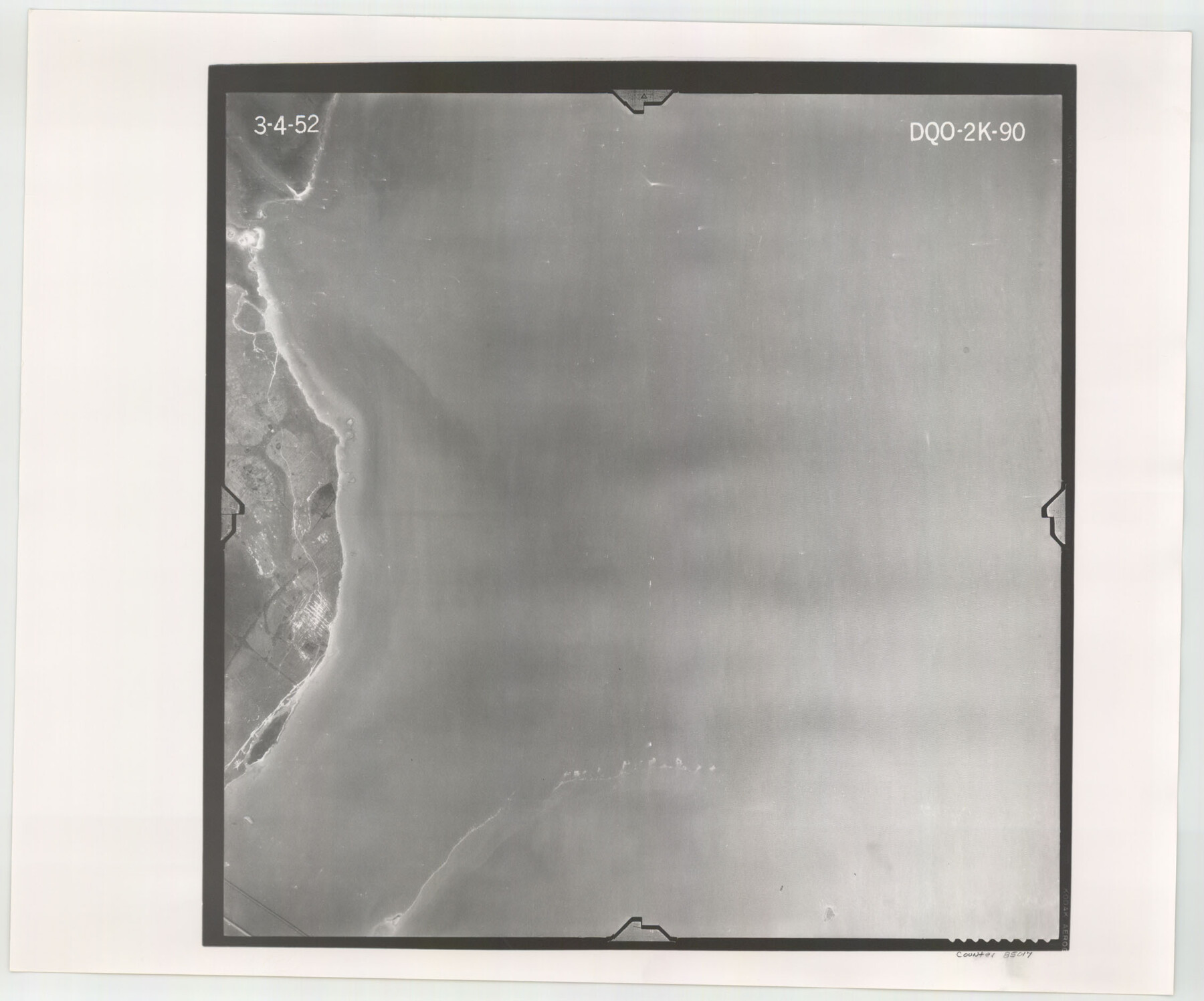
Flight Mission No. DQO-2K, Frame 90, Galveston County
DQO-2K-90
-
Map/Doc
85017
-
Collection
General Map Collection
-
Object Dates
1952/3/4 (Creation Date)
-
People and Organizations
U. S. Department of Agriculture (Publisher)
-
Counties
Galveston
-
Subjects
Aerial Photograph
-
Height x Width
18.8 x 22.6 inches
47.8 x 57.4 cm
-
Comments
Flown by Aero Exploration Company of Tulsa, Oklahoma.
Part of: General Map Collection
Hood County Sketch File 3

Print $4.00
- Digital $50.00
Hood County Sketch File 3
1877
Size 12.7 x 8.1 inches
Map/Doc 26573
Flight Mission No. DQN-3K, Frame 7, Calhoun County

Print $20.00
- Digital $50.00
Flight Mission No. DQN-3K, Frame 7, Calhoun County
1953
Size 18.6 x 22.2 inches
Map/Doc 84339
Presidio County Sketch File 72

Print $6.00
- Digital $50.00
Presidio County Sketch File 72
1943
Size 13.3 x 8.8 inches
Map/Doc 34679
Galveston County Sketch File 11

Print $40.00
- Digital $50.00
Galveston County Sketch File 11
Size 16.3 x 13.2 inches
Map/Doc 23374
Gillespie County Rolled Sketch 1

Print $20.00
- Digital $50.00
Gillespie County Rolled Sketch 1
1956
Size 19.7 x 36.1 inches
Map/Doc 6008
Travis County Sketch File 73

Print $4.00
- Digital $50.00
Travis County Sketch File 73
1847
Size 13.0 x 8.3 inches
Map/Doc 38462
Denton County Working Sketch 2

Print $20.00
- Digital $50.00
Denton County Working Sketch 2
Size 21.2 x 17.7 inches
Map/Doc 68607
Comanche County Working Sketch 3

Print $20.00
- Digital $50.00
Comanche County Working Sketch 3
1919
Size 21.9 x 12.6 inches
Map/Doc 68137
Map Showing Location of Dallas & Greenville Railway through Hunt County, Texas

Print $2.00
- Digital $50.00
Map Showing Location of Dallas & Greenville Railway through Hunt County, Texas
Size 11.9 x 8.2 inches
Map/Doc 64486
Kent County Sketch File 12

Print $20.00
- Digital $50.00
Kent County Sketch File 12
1911
Size 26.8 x 23.6 inches
Map/Doc 11916
Rio Grande Rectification Project, El Paso and Juarez Valley

Print $3.00
- Digital $50.00
Rio Grande Rectification Project, El Paso and Juarez Valley
1935
Size 9.7 x 14.9 inches
Map/Doc 1749
Flight Mission No. BRE-1P, Frame 114, Nueces County

Print $20.00
- Digital $50.00
Flight Mission No. BRE-1P, Frame 114, Nueces County
1956
Size 18.6 x 22.9 inches
Map/Doc 86680
You may also like
Baylor County Working Sketch 14

Print $40.00
- Digital $50.00
Baylor County Working Sketch 14
1982
Size 33.5 x 55.1 inches
Map/Doc 67299
Corpus Christi is the Sportsman's Paradise

Print $20.00
Corpus Christi is the Sportsman's Paradise
1942
Size 26.8 x 16.4 inches
Map/Doc 79331

[Double Lakes Area Northwest of Tohoka, Block 3, Surveys 319, 321, and 322]
![91298, [Double Lakes Area Northwest of Tohoka, Block 3, Surveys 319, 321, and 322], Twichell Survey Records](https://historictexasmaps.com/wmedia_w700/maps/91298-1.tif.jpg)
Print $20.00
- Digital $50.00
[Double Lakes Area Northwest of Tohoka, Block 3, Surveys 319, 321, and 322]
Size 21.1 x 20.1 inches
Map/Doc 91298
Jack County Sketch File 9a

Print $6.00
- Digital $50.00
Jack County Sketch File 9a
1857
Size 12.5 x 7.8 inches
Map/Doc 27522
Kendall County Working Sketch 27

Print $20.00
- Digital $50.00
Kendall County Working Sketch 27
1994
Size 25.0 x 37.5 inches
Map/Doc 66700
Ward County Working Sketch 28

Print $40.00
- Digital $50.00
Ward County Working Sketch 28
1964
Size 60.9 x 29.1 inches
Map/Doc 72334
Pecos County Working Sketch 121

Print $20.00
- Digital $50.00
Pecos County Working Sketch 121
1973
Size 44.3 x 37.7 inches
Map/Doc 71594
Coryell County Working Sketch 3

Print $20.00
- Digital $50.00
Coryell County Working Sketch 3
1928
Size 23.6 x 22.5 inches
Map/Doc 68210
Potter County Boundary File 4

Print $30.00
- Digital $50.00
Potter County Boundary File 4
Size 14.6 x 9.3 inches
Map/Doc 57997
[Sketch showing surveys on the north side of the Canadian River, Blocks B-11, L, O-18, and G and M 2 and 3]
![91737, [Sketch showing surveys on the north side of the Canadian River, Blocks B-11, L, O-18, and G and M 2 and 3], Twichell Survey Records](https://historictexasmaps.com/wmedia_w700/maps/91737-1.tif.jpg)
Print $20.00
- Digital $50.00
[Sketch showing surveys on the north side of the Canadian River, Blocks B-11, L, O-18, and G and M 2 and 3]
1883
Size 35.4 x 25.3 inches
Map/Doc 91737
Crockett County Working Sketch 94

Print $20.00
- Digital $50.00
Crockett County Working Sketch 94
1979
Size 43.1 x 28.7 inches
Map/Doc 68427