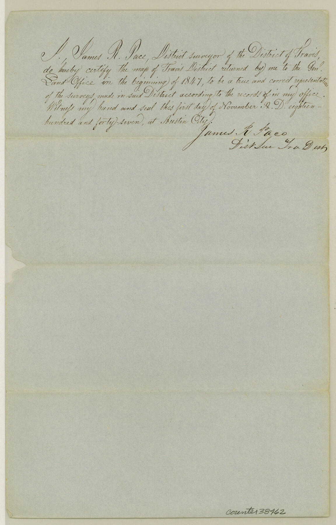
Travis County Sketch File 73
[Certificate of District Surveyor to the correctness of District Map returned to the GLO in 1847]
-
Map/Doc
38462
-
Collection
General Map Collection
-
Object Dates
11/1/1847 (Creation Date)
12/11/1984 (File Date)
-
People and Organizations
James R. Pace (Surveyor/Engineer)
-
Counties
Travis
-
Subjects
Surveying Sketch File
-
Height x Width
13.0 x 8.3 inches
33.0 x 21.1 cm
-
Medium
paper, manuscript
Part of: General Map Collection
Denton County Boundary File 4 and 4a and 4b and 4c

Print $14.00
- Digital $50.00
Denton County Boundary File 4 and 4a and 4b and 4c
Size 11.2 x 8.5 inches
Map/Doc 52441
Flight Mission No. DCL-6C, Frame 77, Kenedy County

Print $20.00
- Digital $50.00
Flight Mission No. DCL-6C, Frame 77, Kenedy County
1943
Size 18.5 x 22.3 inches
Map/Doc 85919
Terry County Rolled Sketch 4

Print $20.00
- Digital $50.00
Terry County Rolled Sketch 4
Size 38.7 x 36.8 inches
Map/Doc 9994
Limestone County Sketch File 11

Print $4.00
- Digital $50.00
Limestone County Sketch File 11
1881
Size 7.9 x 9.5 inches
Map/Doc 30177
Flight Mission No. DQO-8K, Frame 71, Galveston County

Print $20.00
- Digital $50.00
Flight Mission No. DQO-8K, Frame 71, Galveston County
1952
Size 18.6 x 22.4 inches
Map/Doc 85175
Runnels County Sketch File H

Print $4.00
Runnels County Sketch File H
1890
Size 14.3 x 8.8 inches
Map/Doc 35450
Pecos County Rolled Sketch 184

Print $20.00
- Digital $50.00
Pecos County Rolled Sketch 184
1977
Size 44.4 x 30.0 inches
Map/Doc 7303
Liberty County Working Sketch 89

Print $20.00
- Digital $50.00
Liberty County Working Sketch 89
1993
Size 45.0 x 26.2 inches
Map/Doc 70549
Hunt County Rolled Sketch 1

Print $20.00
- Digital $50.00
Hunt County Rolled Sketch 1
Size 28.3 x 18.4 inches
Map/Doc 6266
Hardeman County Sketch File 18

Print $8.00
- Digital $50.00
Hardeman County Sketch File 18
Size 13.1 x 8.2 inches
Map/Doc 25026
Current Miscellaneous File 114

Print $16.00
- Digital $50.00
Current Miscellaneous File 114
1985
Size 8.9 x 11.3 inches
Map/Doc 74803
Erath County Rolled Sketch 2B

Print $20.00
- Digital $50.00
Erath County Rolled Sketch 2B
Size 15.5 x 20.9 inches
Map/Doc 5863
You may also like
Haskell County Rolled Sketch 10

Print $20.00
- Digital $50.00
Haskell County Rolled Sketch 10
1981
Size 33.2 x 14.3 inches
Map/Doc 6169
Nueces County NRC Article 33.136 Location Key Sheet

Print $20.00
- Digital $50.00
Nueces County NRC Article 33.136 Location Key Sheet
1975
Size 27.0 x 22.8 inches
Map/Doc 77033
Webb County Sketch File 4-1

Print $6.00
- Digital $50.00
Webb County Sketch File 4-1
1874
Size 10.3 x 8.2 inches
Map/Doc 39722
[Southeast Portion of Lubbock County]
![91313, [Southeast Portion of Lubbock County], Twichell Survey Records](https://historictexasmaps.com/wmedia_w700/maps/91313-1.tif.jpg)
Print $20.00
- Digital $50.00
[Southeast Portion of Lubbock County]
Size 24.7 x 18.5 inches
Map/Doc 91313
Erath County Working Sketch 41

Print $20.00
- Digital $50.00
Erath County Working Sketch 41
Size 25.5 x 29.0 inches
Map/Doc 69122
Flight Mission No. DAG-17K, Frame 119, Matagorda County

Print $20.00
- Digital $50.00
Flight Mission No. DAG-17K, Frame 119, Matagorda County
1952
Size 16.4 x 16.5 inches
Map/Doc 86339
Wharton County Boundary File 1b

Print $20.00
- Digital $50.00
Wharton County Boundary File 1b
Size 15.1 x 26.6 inches
Map/Doc 59855
Flight Mission No. DQO-2K, Frame 160, Galveston County

Print $20.00
- Digital $50.00
Flight Mission No. DQO-2K, Frame 160, Galveston County
1952
Size 18.7 x 22.4 inches
Map/Doc 85049

Van Zandt County Sketch File 25

Print $4.00
- Digital $50.00
Van Zandt County Sketch File 25
Size 7.6 x 8.8 inches
Map/Doc 39443
Flight Mission No. DQO-8K, Frame 132, Galveston County

Print $20.00
- Digital $50.00
Flight Mission No. DQO-8K, Frame 132, Galveston County
1952
Size 18.8 x 22.6 inches
Map/Doc 85197
[H. & T. C. Block 47 and Vicinity]
![91423, [H. & T. C. Block 47 and Vicinity], Twichell Survey Records](https://historictexasmaps.com/wmedia_w700/maps/91423-1.tif.jpg)
Print $20.00
- Digital $50.00
[H. & T. C. Block 47 and Vicinity]
1887
Size 16.3 x 18.8 inches
Map/Doc 91423