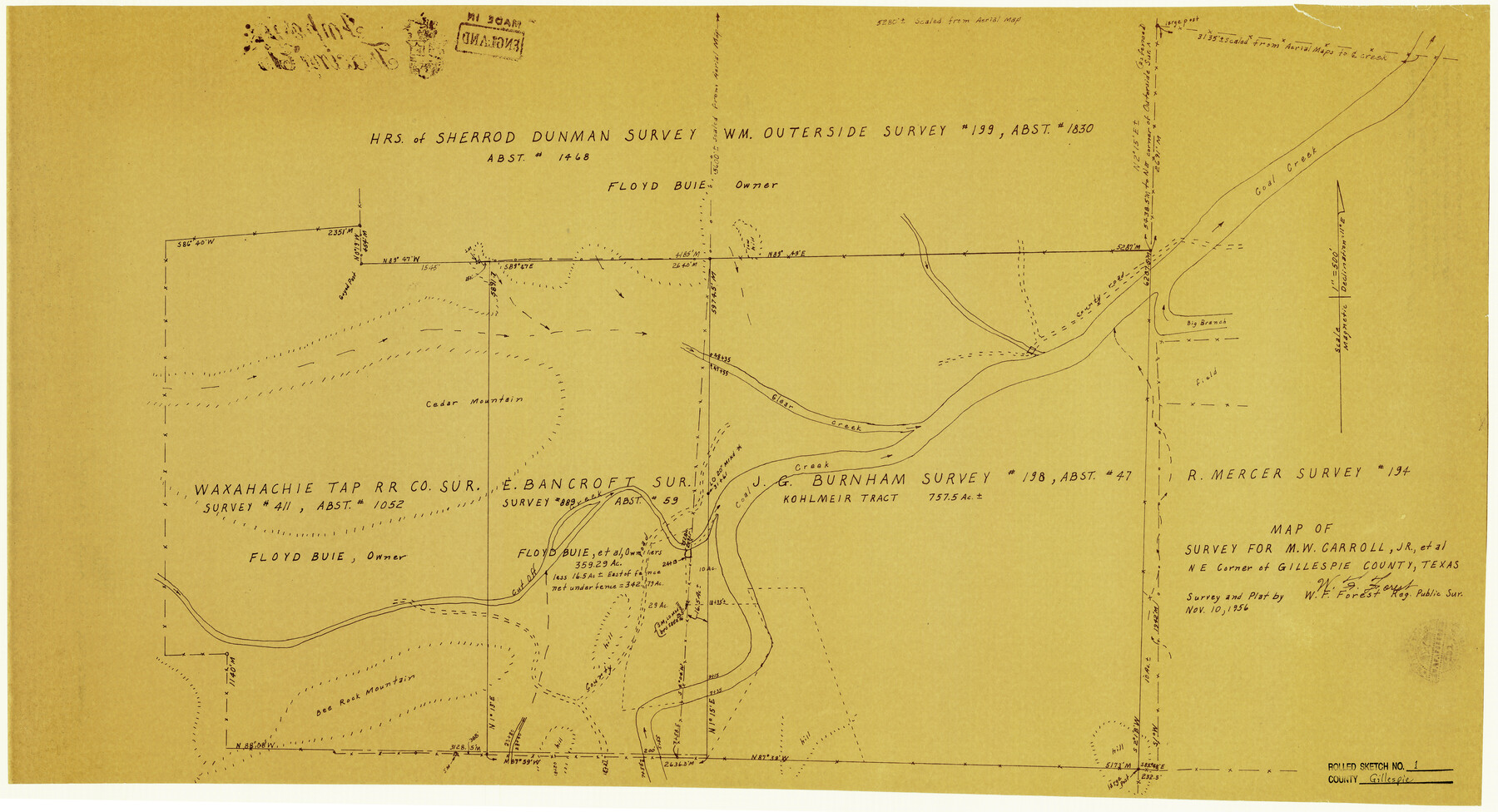
Gillespie County Rolled Sketch 1
Map of survey for M.W. Carroll, Jr., et al - NE Corner of Gillespie County, Texas
- 
                          Map/Doc
6008
 - 
                            Collection
General Map Collection
 - 
                            Object Dates
11/10/1956 (Creation Date)
 - 
                            People and Organizations
W.F. Forest (Surveyor/Engineer)
 - 
                            Counties
Gillespie
 - 
                            Subjects
Surveying Rolled Sketch
 - 
                            Height x Width
19.7 x 36.1 inches
50.0 x 91.7 cm
 - 
                            Medium
blueprint/diazo
 - 
                            Scale
1" = 500 feet
 
Part of: General Map Collection
            Lamb County Rolled Sketch 3


                                            Print $20.00                    
                                             -                         Digital $50.00                                    
                Lamb County Rolled Sketch 3
1917
Size 23.0 x 42.5 inches
                                Map/Doc 9413
            
            Harris County Working Sketch 121


                                            Print $20.00                    
                                             -                         Digital $50.00                                    
                Harris County Working Sketch 121
1985
Size 34.4 x 18.6 inches
                                Map/Doc 66013
            
            Map of the United States and Territories to accompany annual report of Hon. N.C. McFarland, Commissioner, General Land Office for fiscal year which ended June 30, 1884


                                            Print $20.00                    
                                             -                         Digital $50.00                                    
                Map of the United States and Territories to accompany annual report of Hon. N.C. McFarland, Commissioner, General Land Office for fiscal year which ended June 30, 1884
Size 27.0 x 39.3 inches
                                Map/Doc 96631
            
            Floyd County Sketch File 34


                                            Print $4.00                    
                                             -                         Digital $50.00                                    
                Floyd County Sketch File 34
1892
Size 11.3 x 8.9 inches
                                Map/Doc 22798
            
            Eastland County Sketch File 10


                                            Print $42.00                    
                                             -                         Digital $50.00                                    
                Eastland County Sketch File 10
Size 7.0 x 7.8 inches
                                Map/Doc 21582
            
            Cottle County Rolled Sketch 12


                                            Print $20.00                    
                                             -                         Digital $50.00                                    
                Cottle County Rolled Sketch 12
1963
Size 34.2 x 25.7 inches
                                Map/Doc 5549
            
            La Salle County Working Sketch 36


                                            Print $20.00                    
                                             -                         Digital $50.00                                    
                La Salle County Working Sketch 36
1958
Size 18.8 x 42.6 inches
                                Map/Doc 70337
            
            Pecos County Sketch File 29c


                                            Print $14.00                    
                                             -                         Digital $50.00                                    
                Pecos County Sketch File 29c
1929
Size 11.2 x 8.8 inches
                                Map/Doc 33698
            
            Bee County Working Sketch 33


                                            Print $20.00                    
                                             -                         Digital $50.00                                    
                Bee County Working Sketch 33
1980
Size 32.0 x 28.2 inches
                                Map/Doc 67284
            
            Fannin County Rolled Sketch 18A


                                            Print $20.00                    
                                             -                         Digital $50.00                                    
                Fannin County Rolled Sketch 18A
Size 15.1 x 33.6 inches
                                Map/Doc 5868
            
            Fort Bend County Rolled Sketch 3


                                            Print $20.00                    
                                             -                         Digital $50.00                                    
                Fort Bend County Rolled Sketch 3
1958
Size 31.4 x 31.5 inches
                                Map/Doc 5893
            You may also like
            Fort Bend County State Real Property Sketch 1


                                            Print $40.00                    
                                             -                         Digital $50.00                                    
                Fort Bend County State Real Property Sketch 1
1986
Size 34.7 x 43.2 inches
                                Map/Doc 61675
            
            Rains County Rolled Sketch 3


                                            Print $40.00                    
                                             -                         Digital $50.00                                    
                Rains County Rolled Sketch 3
1992
Size 56.2 x 38.4 inches
                                Map/Doc 8353
            
            South Part Brewster Co.


                                            Print $40.00                    
                                             -                         Digital $50.00                                    
                South Part Brewster Co.
1915
Size 39.2 x 51.8 inches
                                Map/Doc 4760
            
            Texas 1971 Official State Highway Map


                                                                    Digital $50.00                                    
                Texas 1971 Official State Highway Map
Size 28.3 x 36.5 inches
                                Map/Doc 94316
            
            Caldwell County Working Sketch 10


                                            Print $40.00                    
                                             -                         Digital $50.00                                    
                Caldwell County Working Sketch 10
1977
Size 46.2 x 50.5 inches
                                Map/Doc 67840
            
            Flight Mission No. DAG-24K, Frame 150, Matagorda County


                                            Print $20.00                    
                                             -                         Digital $50.00                                    
                Flight Mission No. DAG-24K, Frame 150, Matagorda County
1953
Size 18.5 x 22.2 inches
                                Map/Doc 86564
            
            Map of Upton County


                                            Print $20.00                    
                                             -                         Digital $50.00                                    
                Map of Upton County
1889
Size 23.4 x 21.4 inches
                                Map/Doc 4104
            
            Val Verde County Working Sketch 65


                                            Print $20.00                    
                                             -                         Digital $50.00                                    
                Val Verde County Working Sketch 65
1960
Size 30.9 x 31.8 inches
                                Map/Doc 72200
            
            Kimble County Working Sketch 71


                                            Print $20.00                    
                                             -                         Digital $50.00                                    
                Kimble County Working Sketch 71
1965
Size 47.1 x 22.0 inches
                                Map/Doc 70139
            
            Fractional Township No. 10 South Range No. 26 East of the Indian Meridian, Indian Territory


                                            Print $20.00                    
                                             -                         Digital $50.00                                    
                Fractional Township No. 10 South Range No. 26 East of the Indian Meridian, Indian Territory
1897
Size 19.2 x 24.3 inches
                                Map/Doc 75245
            
            [Sketch in Southeast Part of County around J. H. Gibson Sections 1 and 2]


                                            Print $2.00                    
                                             -                         Digital $50.00                                    
                [Sketch in Southeast Part of County around J. H. Gibson Sections 1 and 2]
Size 14.2 x 7.3 inches
                                Map/Doc 91906