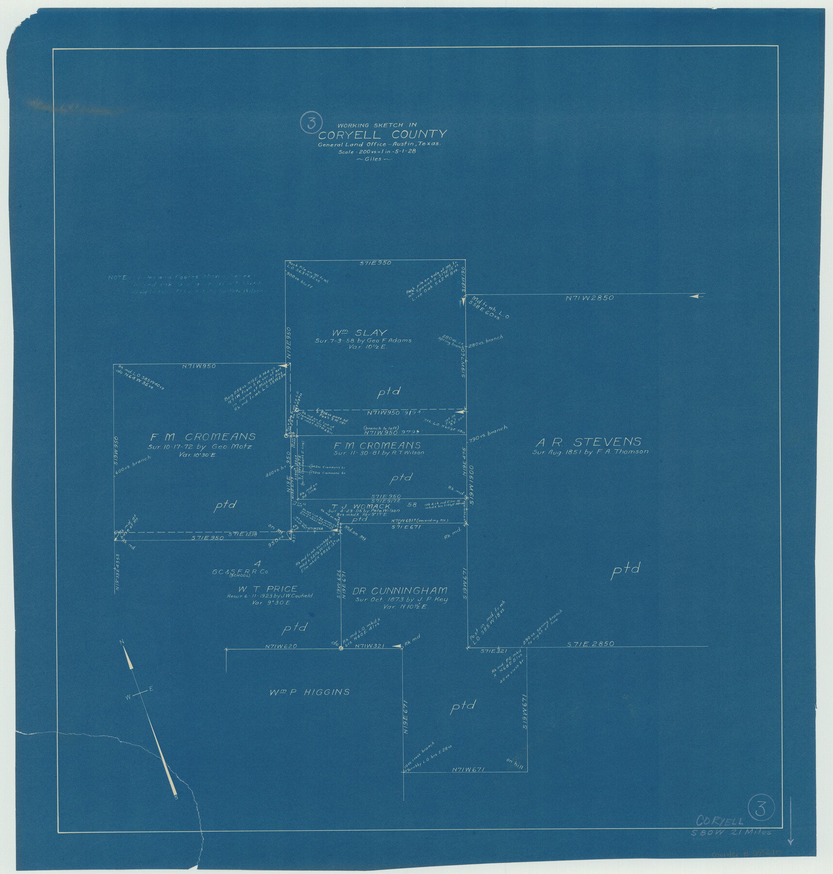
Coryell County Working Sketch 3
-
Map/Doc
68210
-
Collection
General Map Collection
-
Object Dates
5/1/1928 (Creation Date)
-
People and Organizations
J. Bascom Giles (Draftsman)
-
Counties
Coryell
-
Subjects
Surveying Working Sketch
-
Height x Width
23.6 x 22.5 inches
59.9 x 57.2 cm
-
Scale
1" = 200 varas
Part of: General Map Collection
Kendall County Working Sketch 28

Print $20.00
- Digital $50.00
Kendall County Working Sketch 28
1995
Size 36.0 x 37.2 inches
Map/Doc 70001
Flight Mission No. CLL-1N, Frame 76, Willacy County

Print $20.00
- Digital $50.00
Flight Mission No. CLL-1N, Frame 76, Willacy County
1954
Size 18.3 x 22.0 inches
Map/Doc 87022

Yoakum County Sketch File 1

Print $10.00
- Digital $50.00
Yoakum County Sketch File 1
Size 9.4 x 8.3 inches
Map/Doc 40697
Padre Island, Register No. 1485b

Print $40.00
- Digital $50.00
Padre Island, Register No. 1485b
1881
Size 55.6 x 37.3 inches
Map/Doc 73608
Hopkins County Sketch File 16a

Print $4.00
- Digital $50.00
Hopkins County Sketch File 16a
Size 12.1 x 7.6 inches
Map/Doc 26715
Brazoria County Rolled Sketch 49

Print $20.00
- Digital $50.00
Brazoria County Rolled Sketch 49
1948
Size 23.8 x 36.1 inches
Map/Doc 5182
Wheeler County Sketch File 4

Print $30.00
- Digital $50.00
Wheeler County Sketch File 4
1886
Size 9.1 x 8.4 inches
Map/Doc 40000
Lipscomb County Boundary File 8

Print $4.00
- Digital $50.00
Lipscomb County Boundary File 8
Size 11.1 x 8.6 inches
Map/Doc 56333
Hardin County Working Sketch 38

Print $20.00
- Digital $50.00
Hardin County Working Sketch 38
1981
Size 37.2 x 19.4 inches
Map/Doc 63436
Palo Pinto County

Print $20.00
- Digital $50.00
Palo Pinto County
1896
Size 27.2 x 22.1 inches
Map/Doc 3937
Hudspeth County Working Sketch 13

Print $40.00
- Digital $50.00
Hudspeth County Working Sketch 13
1952
Size 34.3 x 51.4 inches
Map/Doc 66295
You may also like
Limestone County Sketch File 26

Print $12.00
- Digital $50.00
Limestone County Sketch File 26
Size 14.3 x 8.7 inches
Map/Doc 30210
San Jacinto County Rolled Sketch 13

Print $20.00
- Digital $50.00
San Jacinto County Rolled Sketch 13
1994
Size 32.2 x 23.7 inches
Map/Doc 7562
[I. & G. N. Block 1, sections 64, 65, 67-71 and 545 along river]
![91604, [I. & G. N. Block 1, sections 64, 65, 67-71 and 545 along river], Twichell Survey Records](https://historictexasmaps.com/wmedia_w700/maps/91604-1.tif.jpg)
Print $2.00
- Digital $50.00
[I. & G. N. Block 1, sections 64, 65, 67-71 and 545 along river]
Size 8.9 x 14.4 inches
Map/Doc 91604
Galveston County Working Sketch 6

Print $20.00
- Digital $50.00
Galveston County Working Sketch 6
1934
Size 43.5 x 38.0 inches
Map/Doc 69343
[County School Land Leagues in Bailey County and Lamb County]
![90971, [County School Land Leagues in Bailey County and Lamb County], Twichell Survey Records](https://historictexasmaps.com/wmedia_w700/maps/90971-2.tif.jpg)
Print $3.00
- Digital $50.00
[County School Land Leagues in Bailey County and Lamb County]
1900
Size 10.9 x 16.6 inches
Map/Doc 90971
Travis County Rolled Sketch 31

Print $20.00
- Digital $50.00
Travis County Rolled Sketch 31
1943
Size 43.4 x 27.3 inches
Map/Doc 8033
Nueces County Sketch File 25B

Print $20.00
- Digital $50.00
Nueces County Sketch File 25B
1894
Size 17.6 x 24.6 inches
Map/Doc 42183
Glasscock County Working Sketch 5

Print $20.00
- Digital $50.00
Glasscock County Working Sketch 5
1926
Size 16.1 x 28.0 inches
Map/Doc 63178
Henderson County Rolled Sketch 11

Print $20.00
- Digital $50.00
Henderson County Rolled Sketch 11
1915
Size 29.4 x 42.4 inches
Map/Doc 75950
Ellis County Sketch File 10

Print $40.00
- Digital $50.00
Ellis County Sketch File 10
1860
Size 12.7 x 16.1 inches
Map/Doc 21845
Bell County Working Sketch 20

Print $20.00
- Digital $50.00
Bell County Working Sketch 20
1996
Size 39.5 x 34.7 inches
Map/Doc 67360
Old Miscellaneous File 24

Print $6.00
- Digital $50.00
Old Miscellaneous File 24
1919
Size 14.4 x 8.7 inches
Map/Doc 75629