Kent County Sketch File 12
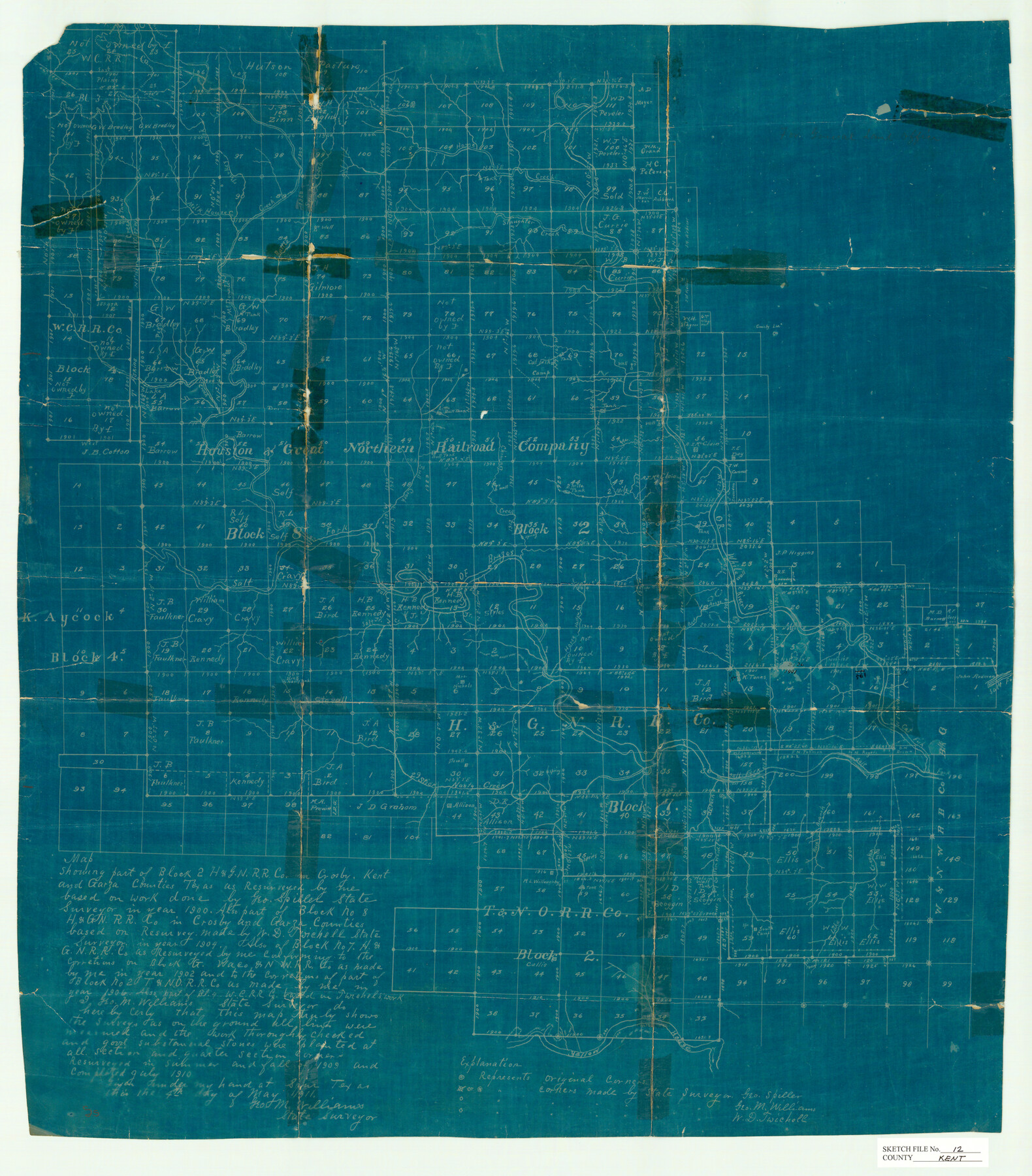
Map showing part of Block 2, H. & G. N. R.R. Co. in Crosby, Kent, and Garza Counties, Texas
-
Map/Doc
11916
-
Collection
General Map Collection
-
Object Dates
5/4/1911 (Creation Date)
1900 (Survey Date)
1904 (Survey Date)
-
People and Organizations
George M. Williams (Surveyor/Engineer)
George Spiller (Surveyor/Engineer)
W.D. Twichell (Surveyor/Engineer)
-
Counties
Kent Crosby Garza Dickens
-
Subjects
Surveying Sketch File
-
Height x Width
26.8 x 23.6 inches
68.1 x 59.9 cm
-
Medium
blueprint/diazo
-
Features
Home Creek
Slaughter Creek
Turkey Creek
Milk House Creek
Lake Creek
McDonald Creek
White River
Brazos River
Horse Hollow
Red Arroyo
Salt Creek
Brazos River
Salt Fork of Brazos River
Stick Nasty Creek
Yellow House River
Part of: General Map Collection
Nueces County Rolled Sketch 126 A-G

Print $22.00
- Digital $50.00
Nueces County Rolled Sketch 126 A-G
1998
Size 11.3 x 8.8 inches
Map/Doc 8962
Cameron County Rolled Sketch 25

Print $20.00
- Digital $50.00
Cameron County Rolled Sketch 25
1977
Size 24.9 x 36.7 inches
Map/Doc 5794
Flight Mission No. DCL-7C, Frame 118, Kenedy County

Print $20.00
- Digital $50.00
Flight Mission No. DCL-7C, Frame 118, Kenedy County
1943
Size 18.4 x 22.3 inches
Map/Doc 86083
Flight Mission No. CUG-1P, Frame 54, Kleberg County

Print $20.00
- Digital $50.00
Flight Mission No. CUG-1P, Frame 54, Kleberg County
1956
Size 18.5 x 22.3 inches
Map/Doc 86132
Township 6 North Range 13 West, North Western District, Louisiana

Print $20.00
- Digital $50.00
Township 6 North Range 13 West, North Western District, Louisiana
1841
Size 19.7 x 24.8 inches
Map/Doc 65864
Flight Mission No. CGI-4N, Frame 188, Cameron County

Print $20.00
- Digital $50.00
Flight Mission No. CGI-4N, Frame 188, Cameron County
1955
Size 18.5 x 22.3 inches
Map/Doc 84691

Presidio County Sketch File R

Print $18.00
- Digital $50.00
Presidio County Sketch File R
Size 10.3 x 8.4 inches
Map/Doc 34590
Jasper County Rolled Sketch 7B

Print $20.00
- Digital $50.00
Jasper County Rolled Sketch 7B
Size 19.7 x 11.6 inches
Map/Doc 6355
[Sketch for Mineral Application 27669 - Trinity River, Frank R. Graves]
![2860, [Sketch for Mineral Application 27669 - Trinity River, Frank R. Graves], General Map Collection](https://historictexasmaps.com/wmedia_w700/maps/2860-1.tif.jpg)
Print $20.00
- Digital $50.00
[Sketch for Mineral Application 27669 - Trinity River, Frank R. Graves]
1934
Size 27.4 x 42.7 inches
Map/Doc 2860
Clay County Sketch File 22

Print $6.00
- Digital $50.00
Clay County Sketch File 22
Size 12.8 x 8.3 inches
Map/Doc 18436
Aransas County Working Sketch 1

Print $20.00
- Digital $50.00
Aransas County Working Sketch 1
1919
Size 13.8 x 27.5 inches
Map/Doc 67168
You may also like
Flight Mission No. DQN-5K, Frame 51, Calhoun County

Print $20.00
- Digital $50.00
Flight Mission No. DQN-5K, Frame 51, Calhoun County
1953
Size 18.6 x 22.2 inches
Map/Doc 84396
La Salle County Working Sketch 14

Print $20.00
- Digital $50.00
La Salle County Working Sketch 14
1941
Size 37.8 x 36.7 inches
Map/Doc 70315
Gaines County Rolled Sketch 30

Print $20.00
- Digital $50.00
Gaines County Rolled Sketch 30
1962
Size 19.4 x 26.3 inches
Map/Doc 5943
Flight Mission No. CRC-3R, Frame 163, Chambers County

Print $20.00
- Digital $50.00
Flight Mission No. CRC-3R, Frame 163, Chambers County
1956
Size 18.7 x 22.4 inches
Map/Doc 84845
Right of Way and Track Map, the Missouri, Kansas and Texas Ry. of Texas - Henrietta Division

Print $20.00
- Digital $50.00
Right of Way and Track Map, the Missouri, Kansas and Texas Ry. of Texas - Henrietta Division
1918
Size 11.8 x 26.9 inches
Map/Doc 64748
Flight Mission No. DAH-9M, Frame 85, Orange County

Print $20.00
- Digital $50.00
Flight Mission No. DAH-9M, Frame 85, Orange County
1953
Size 18.5 x 22.7 inches
Map/Doc 86849
Travis County Rolled Sketch 30

Print $20.00
- Digital $50.00
Travis County Rolled Sketch 30
1943
Size 26.5 x 25.6 inches
Map/Doc 8032
Lamb County Sketch File 11

Print $6.00
- Digital $50.00
Lamb County Sketch File 11
1913
Size 11.5 x 8.8 inches
Map/Doc 29360
Atascosa County Sketch File 25

Print $4.00
- Digital $50.00
Atascosa County Sketch File 25
Size 12.7 x 8.0 inches
Map/Doc 13792
Runnels County Sketch File 27

Print $6.00
Runnels County Sketch File 27
1949
Size 11.5 x 8.9 inches
Map/Doc 35490
Dallas County Sketch File 19 1/2

Print $4.00
- Digital $50.00
Dallas County Sketch File 19 1/2
Size 9.9 x 8.2 inches
Map/Doc 20439
Dr. Ross Trigg's Ranch [Block 29E, Townships 14N and 15N]
![92036, Dr. Ross Trigg's Ranch [Block 29E, Townships 14N and 15N], Twichell Survey Records](https://historictexasmaps.com/wmedia_w700/maps/92036-1.tif.jpg)
Print $20.00
- Digital $50.00
Dr. Ross Trigg's Ranch [Block 29E, Townships 14N and 15N]
Size 25.8 x 19.6 inches
Map/Doc 92036