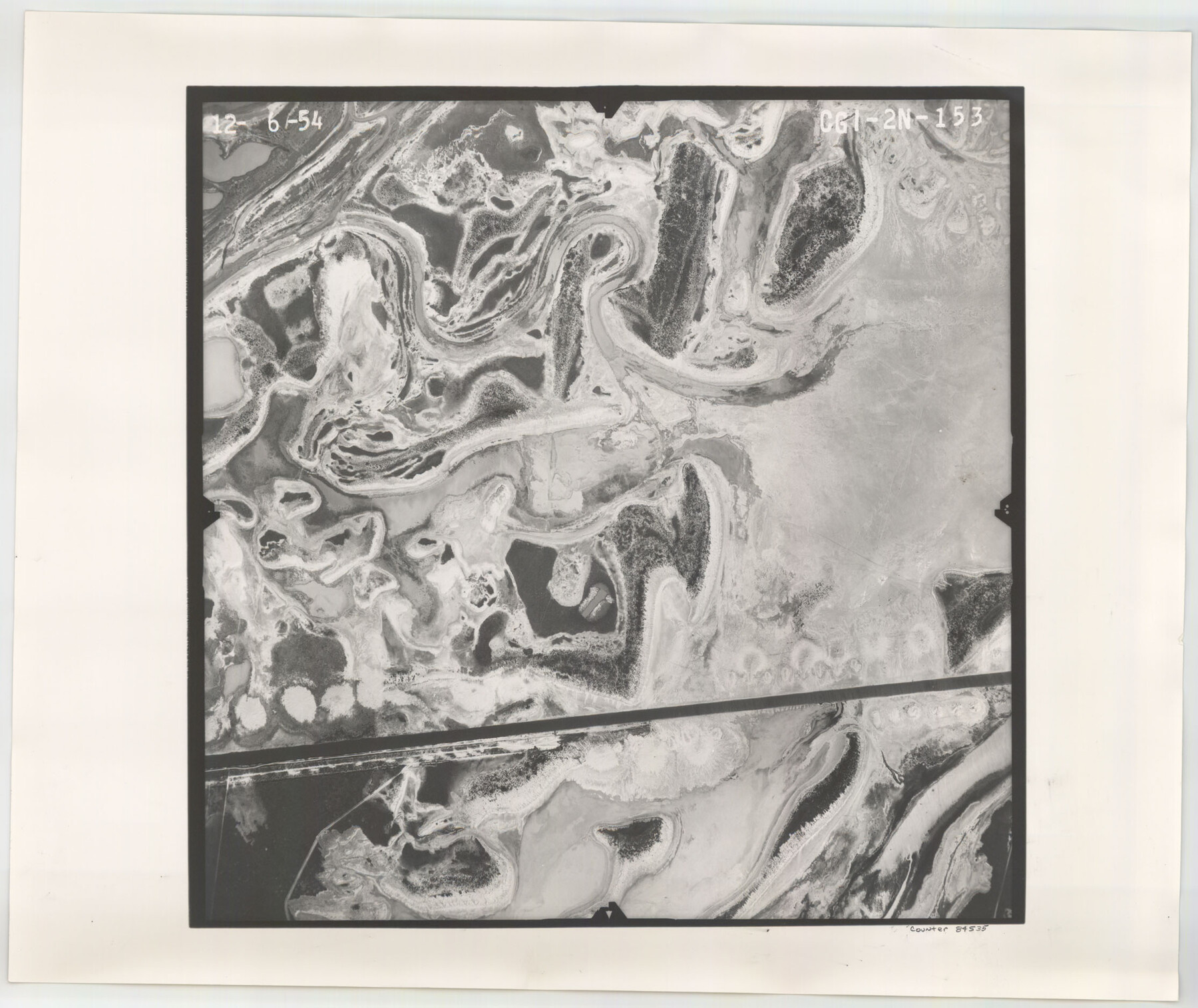
Flight Mission No. CGI-2N, Frame 153, Cameron County
CGI-2N-153
-
Map/Doc
84535
-
Collection
General Map Collection
-
Object Dates
1954/12/6 (Creation Date)
-
People and Organizations
U. S. Department of Agriculture (Publisher)
-
Counties
Cameron
-
Subjects
Aerial Photograph
-
Height x Width
18.8 x 22.3 inches
47.8 x 56.6 cm
-
Comments
Flown by Puckett Aerial Surveys, Inc. of Jackson, Mississippi.
Part of: General Map Collection
[Map of Texas showing Counties, County Seats, Rivers and Location of State Boundary Line Markers]
![60304, [Map of Texas showing Counties, County Seats, Rivers and Location of State Boundary Line Markers], General Map Collection](https://historictexasmaps.com/wmedia_w700/maps/60304.tif.jpg)
Print $20.00
- Digital $50.00
[Map of Texas showing Counties, County Seats, Rivers and Location of State Boundary Line Markers]
1950
Size 30.2 x 32.9 inches
Map/Doc 60304
Denton County Working Sketch 12

Print $20.00
- Digital $50.00
Denton County Working Sketch 12
1960
Size 29.8 x 17.3 inches
Map/Doc 68617
Burnet County Sketch File 20

Print $4.00
- Digital $50.00
Burnet County Sketch File 20
1862
Size 10.1 x 8.0 inches
Map/Doc 16712
Flight Mission No. CGI-1N, Frame 221, Cameron County

Print $20.00
- Digital $50.00
Flight Mission No. CGI-1N, Frame 221, Cameron County
1955
Size 18.5 x 22.2 inches
Map/Doc 84530
Liberty County Sketch File 44

Print $2.00
- Digital $50.00
Liberty County Sketch File 44
Size 6.0 x 10.3 inches
Map/Doc 30002
Hood County Working Sketch 12

Print $40.00
- Digital $50.00
Hood County Working Sketch 12
1978
Size 25.2 x 55.5 inches
Map/Doc 66206
Austin Street Map & Guide

Digital $50.00
Austin Street Map & Guide
Size 35.3 x 23.2 inches
Map/Doc 94434
Aransas County Rolled Sketch 19A

Print $20.00
- Digital $50.00
Aransas County Rolled Sketch 19A
1979
Size 32.0 x 24.8 inches
Map/Doc 76068
Flight Mission No. CUG-1P, Frame 106, Kleberg County

Print $20.00
- Digital $50.00
Flight Mission No. CUG-1P, Frame 106, Kleberg County
1956
Size 18.8 x 22.3 inches
Map/Doc 86156
Zavala County Sketch File 17

Print $64.00
- Digital $50.00
Zavala County Sketch File 17
1900
Size 9.1 x 10.1 inches
Map/Doc 41324
Flight Mission No. CLL-1N, Frame 190, Willacy County

Print $20.00
- Digital $50.00
Flight Mission No. CLL-1N, Frame 190, Willacy County
1954
Size 18.5 x 22.2 inches
Map/Doc 87060
Flight Mission No. CUG-3P, Frame 91, Kleberg County

Print $20.00
- Digital $50.00
Flight Mission No. CUG-3P, Frame 91, Kleberg County
1956
Size 18.4 x 22.2 inches
Map/Doc 86261
You may also like
General Highway Map, Baylor County, Texas

Print $20.00
General Highway Map, Baylor County, Texas
1940
Size 18.3 x 25.1 inches
Map/Doc 79013
Jasper County Sketch File 1a

Print $8.00
- Digital $50.00
Jasper County Sketch File 1a
1859
Size 12.1 x 7.7 inches
Map/Doc 27765
Kinney County

Print $40.00
- Digital $50.00
Kinney County
1955
Size 51.9 x 48.2 inches
Map/Doc 95559
Harris County Working Sketch 57

Print $20.00
- Digital $50.00
Harris County Working Sketch 57
1951
Size 21.7 x 20.0 inches
Map/Doc 65949
Burnet County Working Sketch 16

Print $20.00
- Digital $50.00
Burnet County Working Sketch 16
1979
Size 22.8 x 32.5 inches
Map/Doc 67859
General Highway Map, Nacogdoches County, Texas

Print $20.00
General Highway Map, Nacogdoches County, Texas
1940
Size 18.5 x 24.7 inches
Map/Doc 79205
Presidio County Sketch File 83

Print $8.00
- Digital $50.00
Presidio County Sketch File 83
1949
Size 11.3 x 8.8 inches
Map/Doc 34722
Baylor County Sketch File 11C

Print $20.00
- Digital $50.00
Baylor County Sketch File 11C
1892
Map/Doc 88491
Map of Travis Co.

Print $40.00
- Digital $50.00
Map of Travis Co.
1850
Size 37.2 x 50.8 inches
Map/Doc 78387
Jones County Working Sketch 3

Print $20.00
- Digital $50.00
Jones County Working Sketch 3
1938
Size 28.7 x 25.4 inches
Map/Doc 66641
Sectional Map No. 3 of the lands and of the line of the Texas & Pacific Ry. Co. in Reeves and parts of Tom Green, Pecos, Presidio & El Paso Cos.

Print $20.00
- Digital $50.00
Sectional Map No. 3 of the lands and of the line of the Texas & Pacific Ry. Co. in Reeves and parts of Tom Green, Pecos, Presidio & El Paso Cos.
1885
Size 24.2 x 18.9 inches
Map/Doc 4858
Montgomery County Sketch File 13

Print $40.00
- Digital $50.00
Montgomery County Sketch File 13
1900
Size 17.8 x 14.8 inches
Map/Doc 31803